Saltmarsh management scheme 2014/5
Report prepared by Simon Read with support from Karen Thomas and Trazar Astley-Reid
Project Proposal: Each year Suffolk Yacht Harbour at Levington on the Orwell Estuary in Suffolk must undertake a dredging campaign in the winter months to ensure sufficient depths at all states of the tide for its pontoon berths. Since 1993, it has been licensed to deposit dredging spoil at managed sites on the foreshore approved by Defra and Natural England. The amount discharged annually is between 15,000- 20,000 cubic metres.
The proposal for 2014/15 was to transfer the operation to two degraded SSSI habitats within the SPA (European Marine Site). It has been estimated that the area of saltmarsh has decreased by 59% on the Stour and 46% on the Orwell between 1973 and 1997. The Stour and Orwell SPA supports in excess of 20,000 waterfowl.
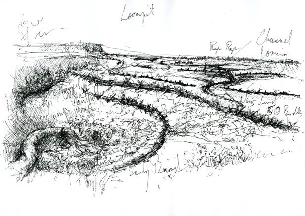
These sites are adjacent to the Yacht Harbour: to the West on the fringing saltmarsh at the head of Levington Creek and to the East on a high mudflat behind a historically breached defence beside Loompit Lake.
The Stour and Orwell Estuaries Management Group (S&OEMG) and Suffolk Yacht Harbour at Levington agreed to collaborate upon this project as a pilot to raise the profile of the strategy for the beneficial use of dredging spoil for saltmarsh restoration. This approach is consistent with the strategy identified in the South Suffolk and Essex Shoreline Management Plan 2011 (SMP) by the Environment Agency as a cost effective option that delivers wider environmental benefits.
The partners in this scheme are Suffolk Yacht Harbour (SYH) and the Stour and Orwell Estuaries Management Group. Suffolk Coast and Heaths Unit (SCHU) supported SYH at a consultative level towards securing the marine license to allow placement of dredged material in new intertidal areas and securing partnership funding elements for the project. The Environment Agency supported the project through providing aerial photographs and LIDAR data and by providing technical expertise and experience through on-site consultation. Suffolk Wildlife Trust have been actively engaged through cooperating over the laying of the pipework over their nature reserve and agreeing to carry out the monitoring programme. The estimated budget for the project including pipework, structures and manpower was £60,856.20, whilst the working fund was £61,199. This fund was made up of in-kind support from Suffolk Wildlife Trust, £4000, and Ipswich Borough Council, £3,000, Environment Agency, £12,000, Suffolk Yacht Harbour, £7,000, Suffolk County Council, £10,000, ABP Ipswich, £2,000, AONB Sustainable Development Fund, £3,000, VEOLIA, £14,199 and £5000 from Suffolk Coastal District Council.
This project was preceded by a thorough consultation exercise, starting in 2012, where all interested parties, stakeholders and local community members were invited to attend events set up by the Stour and Orwell Estuaries Management Group. Consents and licenses were gained from Natural England, Environment Agency and the Marine Management Organisation. The main guidance for this project is the consultation document: “Stour and Orwell Estuaries Management Group working in partnership with Suffolk Yacht Harbour Levington Saltmarsh Restoration & Beneficial Use of Dredgings Project 2013” produced by Trazar Astley Reid and updated in 2014.
The proposal is to extend the pipeline to each of the two sites and to pump from the western end of the marina via existing concrete drains in the wall of the nature reserve beside the saltmarsh at the head of Levington Creek and from the eastern end into the top corner of the Loompit Lake Site. Prior to the operation, each site would be prepared by placing systems of bunds to retain the silt. It is expected that this will be reviewed and monitored on an annual basis and any adjustment deemed necessary to ensure the continuing efficacy of the project should be put in place.
Trazar Astley-Reid of SCHU and Karen Thomas of Environment Agency conducted the initial scoping of the project with Jonathan Dyke of SYH. As a result of this a basic strategy was agreed to make low-key interventions in the channel systems of the two sites, using materials such as coir in innovative ways. SCHU worked up this approach with Kieran O’Mahony, Environmental Scientist and Simon Read, Visual Artist to establish a sustainable design for this intertidal landscape as a model for future initiatives.
An account of the works carried out on site: The aim of this project is to sequester sediment from the annual dredging operation of Suffolk Yacht Harbour and to use it as recharge on two degraded saltmarsh sites immediately to the West and to the East of the Marina. Upon completion, Suffolk Wildlife Trust has undertaken to manage the monitoring programme.
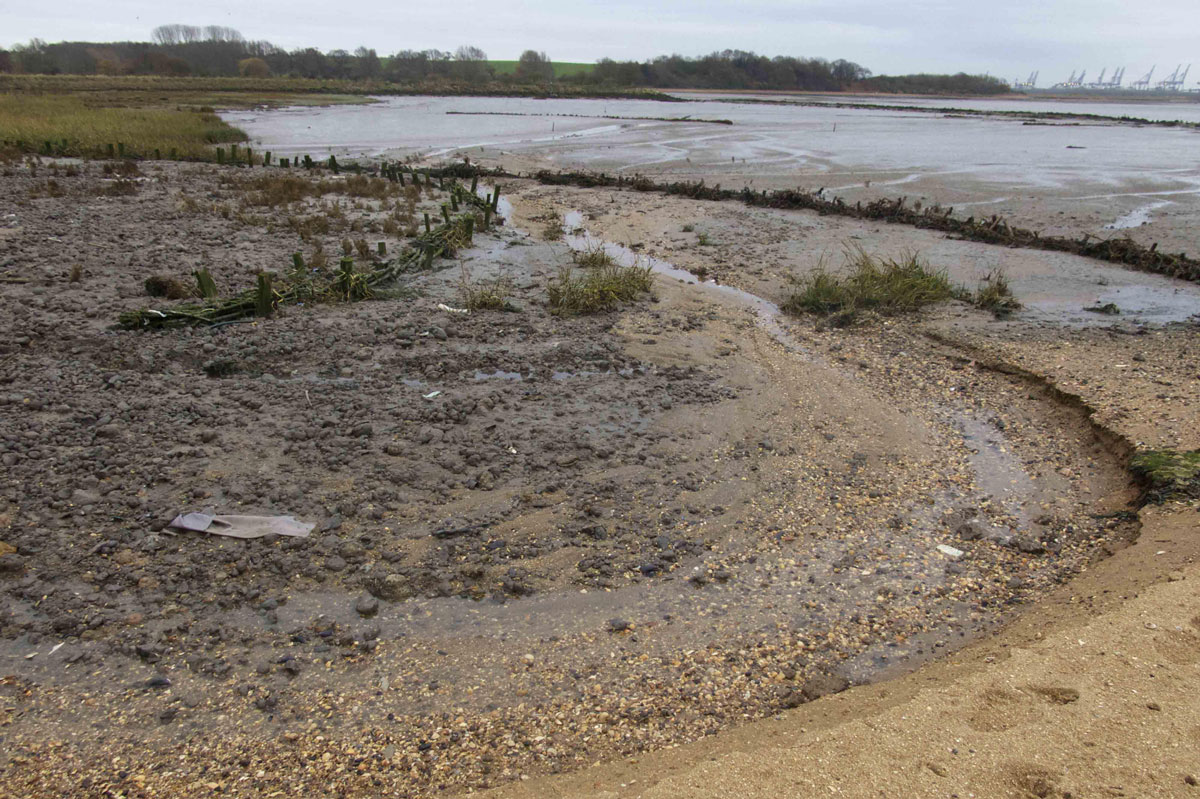
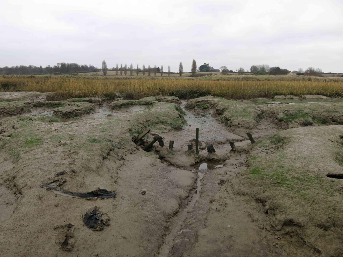
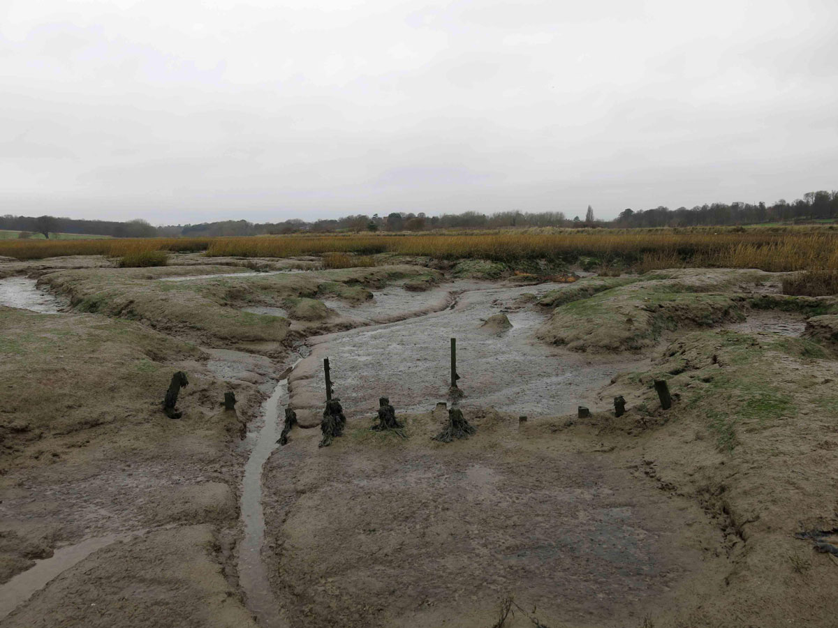
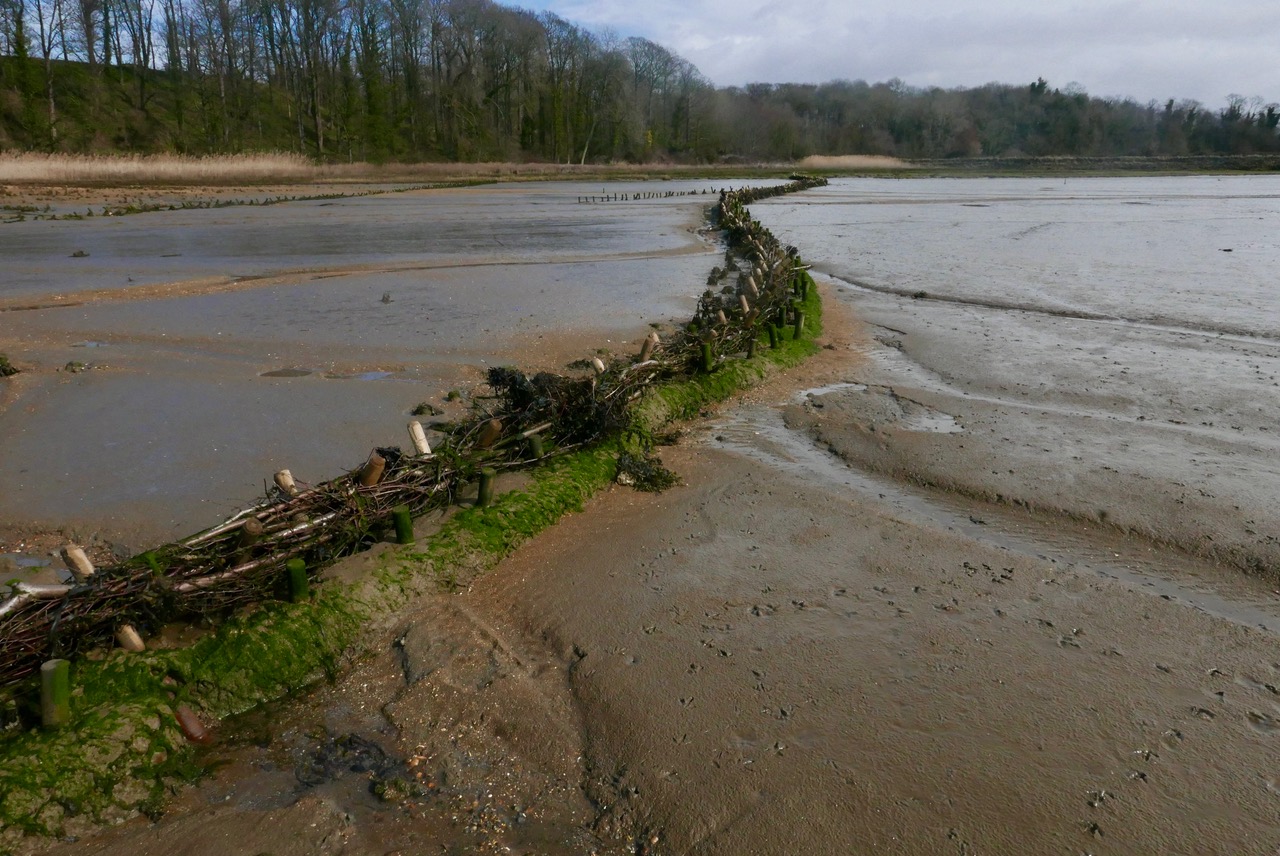
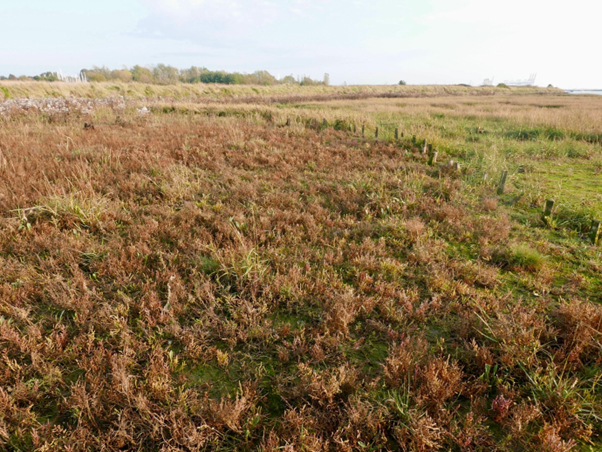
The West Marsh is a substantial area of degraded saltmarsh between the entrance to Levington Creek and Suffolk Yacht Harbour. Although seasonally there is a good crop of Samphire (Salicorna Europaea), Cordgrass (Spartina Anglica) and Sea Aster (Aster Tripolium), there is insufficient overall elevation for this to progress any further beyond pioneer growth apart from a margin of middle marsh close to the defence wall and in isolated patches in the body of the marsh that have been colonised by Sea Purslane (Halimione Portulacoides) and Sea Lavender (Limonium Vulgare).
The proposal is to install a complex of low barriers within the channel system in order to hold back sediment pumped into the site by the yacht harbor during its seasonal dredging operation.
This is a collaborative project between Suffolk Yacht Harbour, and the Stour and Orwell Estuary Management Group, designed and implemented by Kieran O’Mahony and Simon Read. For all parties there is an understanding that the advantages derived from this project are mutual: Suffolk Yacht Harbour could and would have continued to deposit dredging spoil on the foreshore locations in a way that prevents it from returning to the tideway. Transferring the operation to the two new sites will ensure the benefit of an influx of sediment that should eventually raise the levels of the marsh beyond pioneer stage and into a succession of healthy saltmarsh vegetation. This in turn will enhance the biodiversity of the foreshore and provide greater resilience against tidal and wave action.
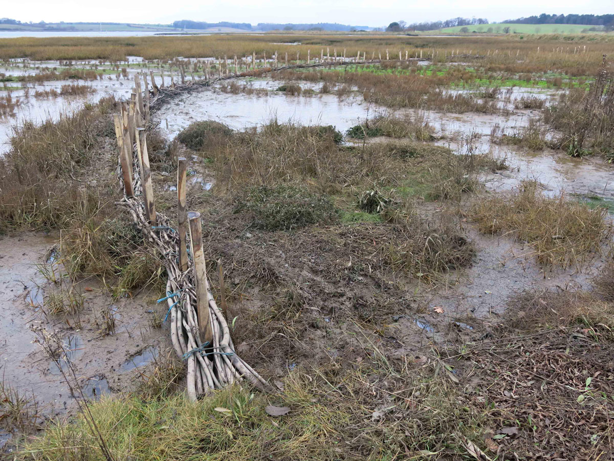
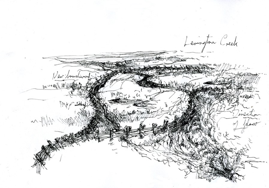
West Marsh, reversed to clarify the channel system
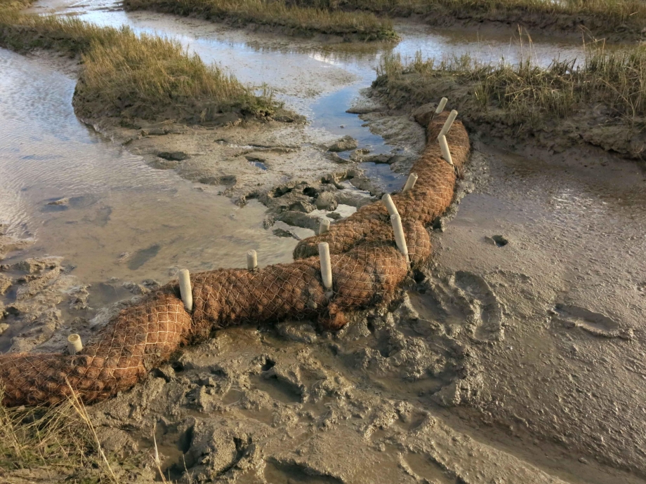
The relative levels of the drain channels and the crest of the saltmarsh are very slight, frequently less than 500mm. Since it does not make sense to install structures reaching beyond these dimensions, we decided to work exclusively with Coir Logs staked directly into the channel bed to impede flow and facilitate the deposition of sediment during the dredging operation. Our approach to this was:
- Map the site and discern the gradients and direction of flow within the marsh.
- Strategically place Coir Logs within the system to incrementally interrupt flow, but avoid the build up of bodies of standing water sufficient to increase hydraulic pressure to the extent that it will cause failure either through undermining or diversion.
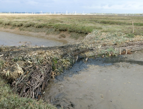
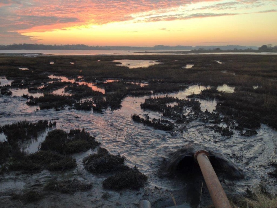
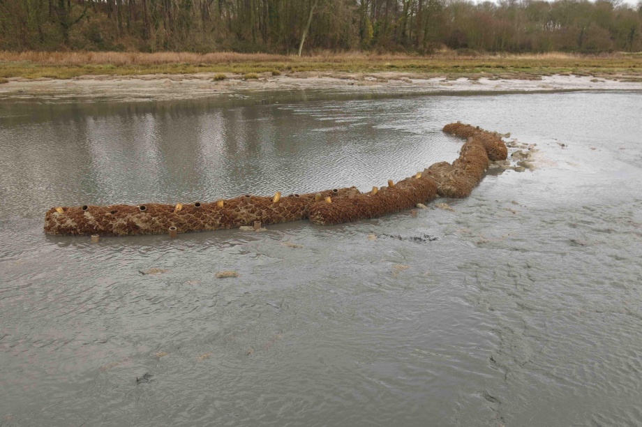
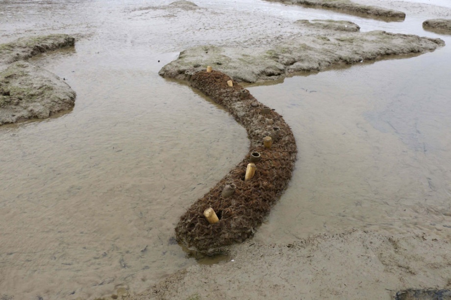
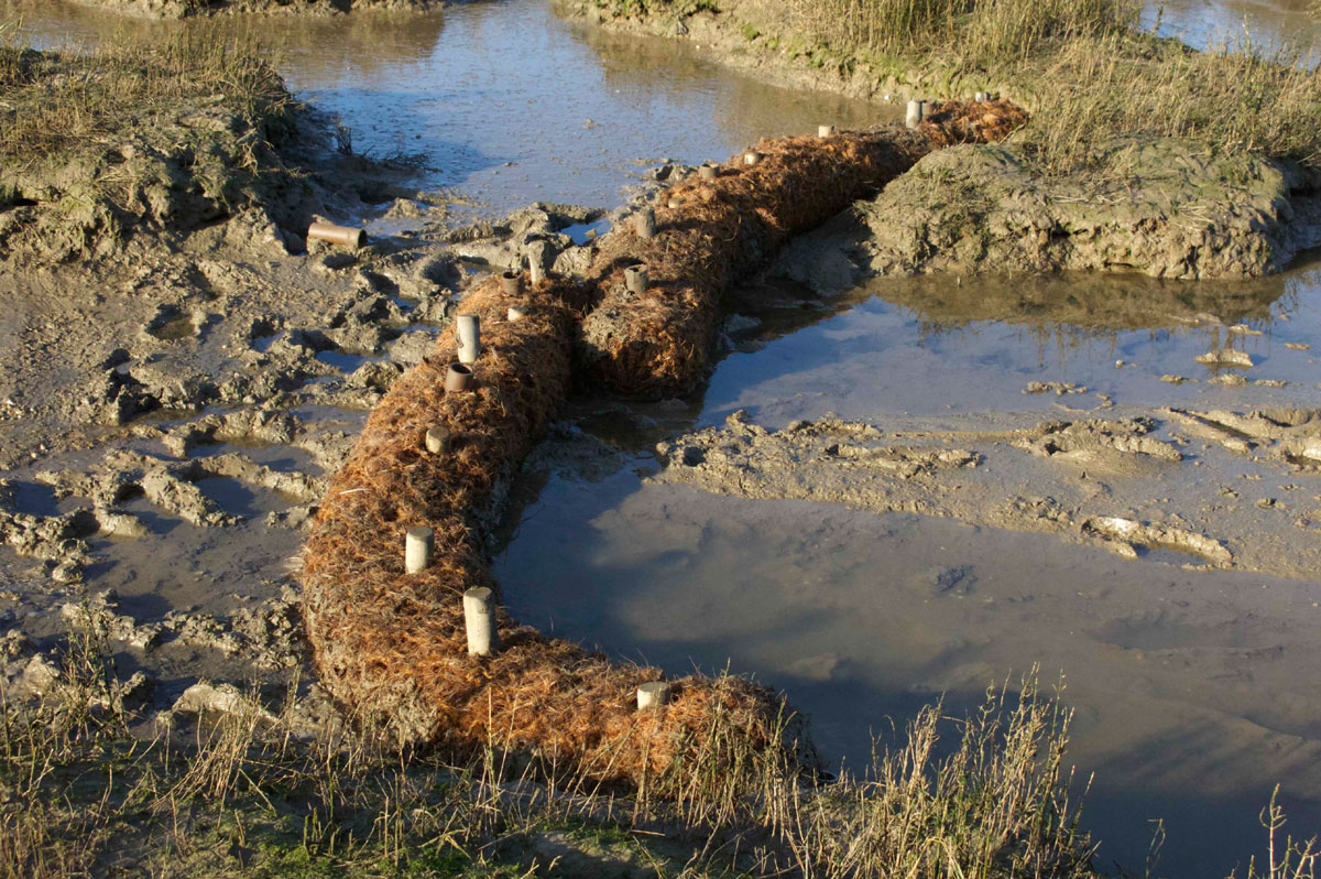
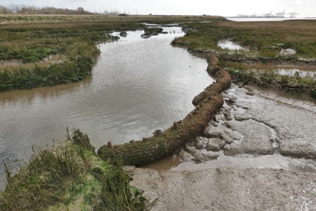
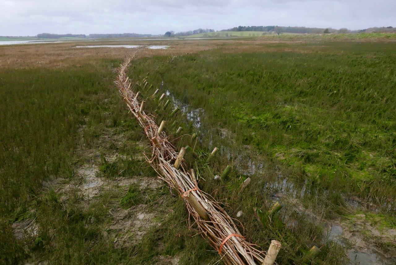
- In the first instance, 48 Coir Logs were staked into the channels radiating from the proposed discharge point. In an effort to mitigate the effects of higher velocities and levels of flow, these are positioned more tightly together near the point of discharge than at the outer limits of the channel system.
- The installation took 5 days from 18th to 23rd August 2014.
This is deliberately a very low-key intervention, with the expectation that it may need additional structural intervention during the course of the dredging campaign and year on year as levels rise.
Suffolk Wildlife Trust have set up a monitoring programme based on transects, fixed-point photography and horizon markers.
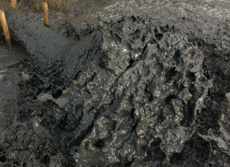
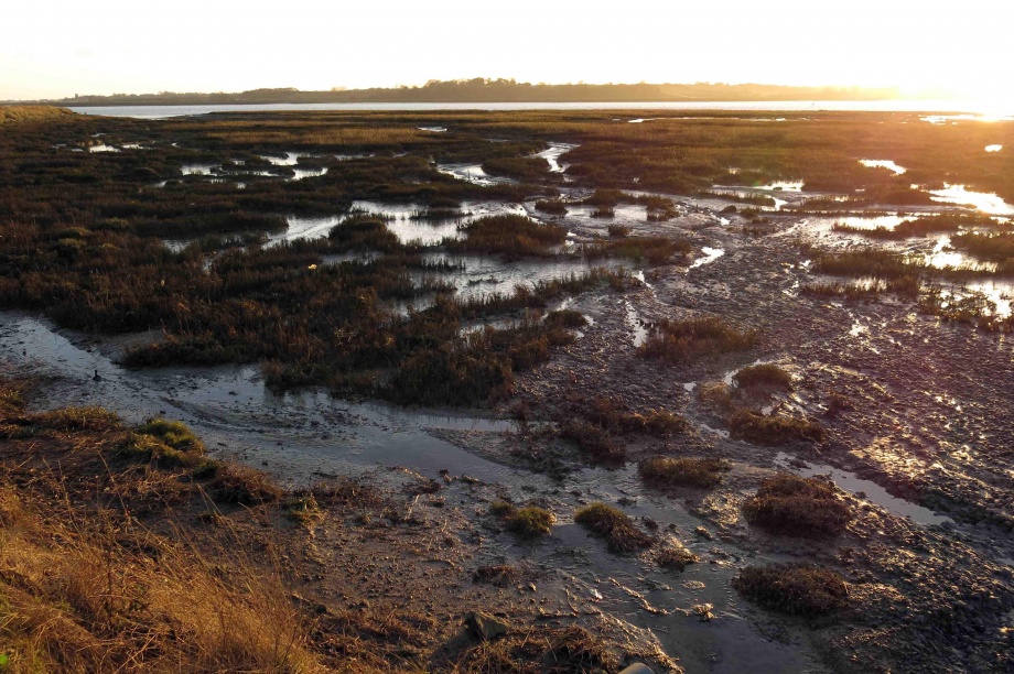
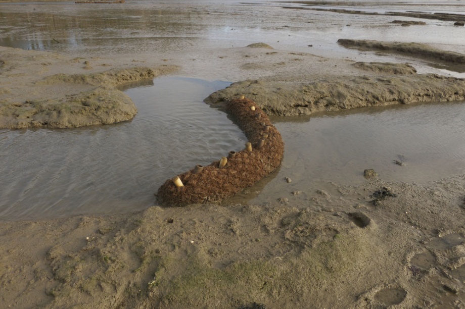
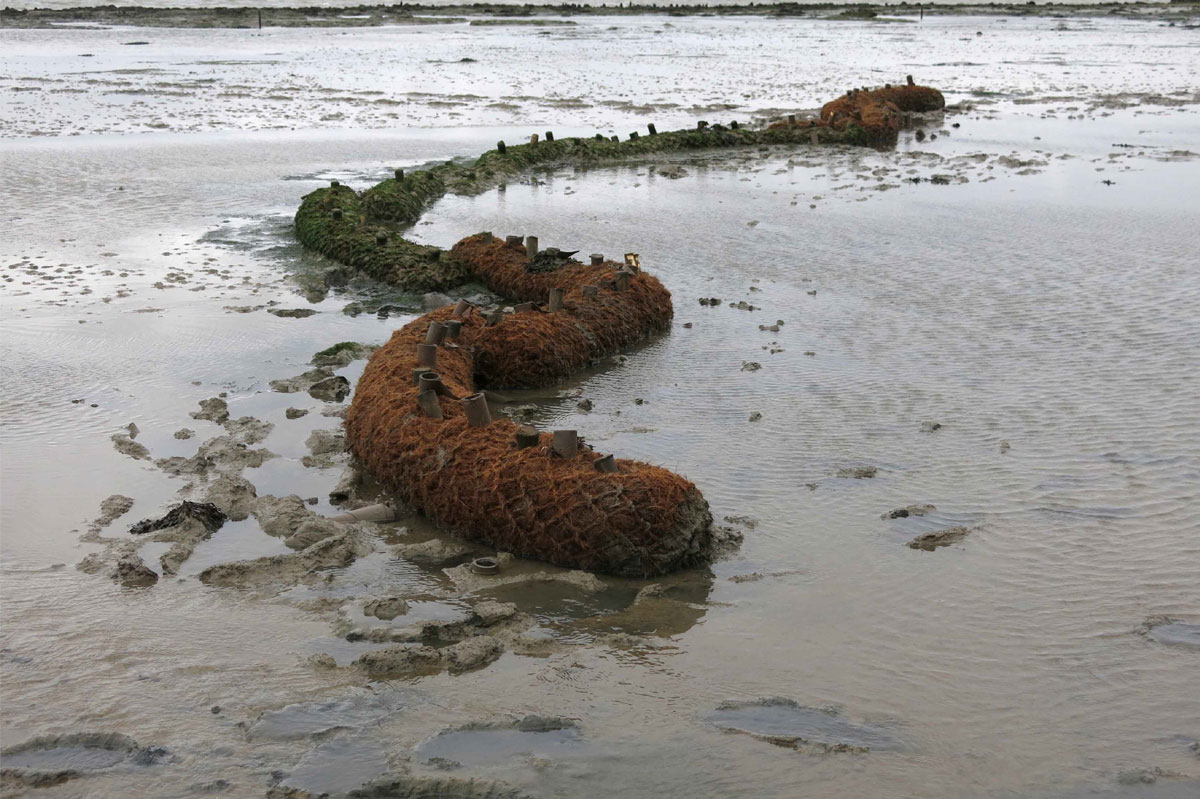
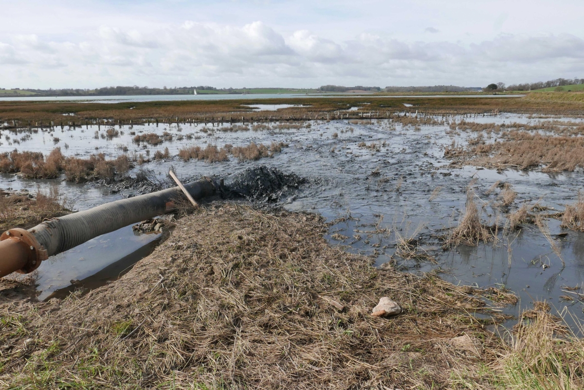
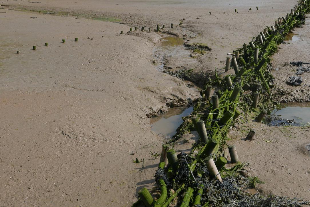
December 19th 2014: After six weeks dredging, the entire channel system within 50metres of the outfall has become smothered by spoil and the coir bunds further downstream are noticeably holding back sediment. After a period of settlement, there will be one further discharge at this site before attention is transferred to the south site beside Loompit Lake.
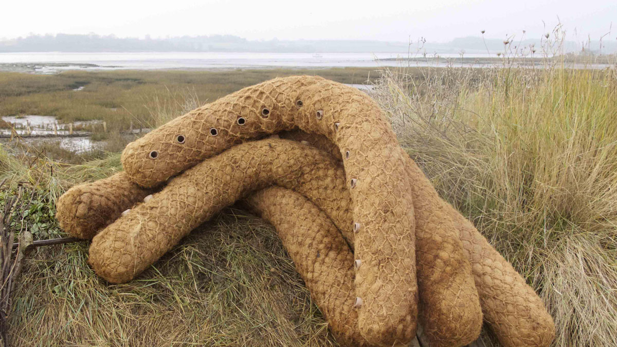
Coir Logs to be located on the western site. 18th August 2014. copyright: Simon Read
The East Site Beside Loompit Lake Is Predominantly Mud Flat With Very A Small Saltmarsh Fringe Of Mainly Sea Purslane And Cordgrass Towards The Landward Side. There Is A Substantial Plume Of Sand At The Western End That Has Progressively Built Up Over At Least Ten Years. This Is Possibly The Result Of Sediment Dropping Out From Dredging Spoil Discharged On The Adjacent Foreshore And Carried In On The Ebb. In The Shelter Of This Formation Examples Of Other Vegetation Types Such As Shrubby Sea Blight (Suaeda Vera), Golden Samphire (Limbarda Crithmoides) And Frosted Orache (Atriplex Laciniata) Have Been Recorded.
The site was a reclaimed field where historically the defences had failed upriver before the construction of Suffolk Yacht Harbour.
From then the process of returning to an intertidal landscape has followed a predictable cycle where, in the first instance, saltmarsh vegetation colonised the hard clay of drained pasture. As the original clay defence walls progressively disintegrated, tidal ingress became more dynamic, eroding the derelict pasture whilst depositing soft estuarine silts. towards the north of the site where it meets rising land, this process is slowing down although the saltmarsh vegetation continues to die away. As in many sites where reclaimed land has returned to the intertidal zone, it remains in a transitional state for a surprisingly long period of time. Eventually without intervention it must reach some kind of equilibrium; but through artificially lowering the tidal dynamic within the site and introducing dredging spoil as recharge, this process is likely to be more rapid and sustainable over a much wider area.
Locations of Coir Logs on North Site
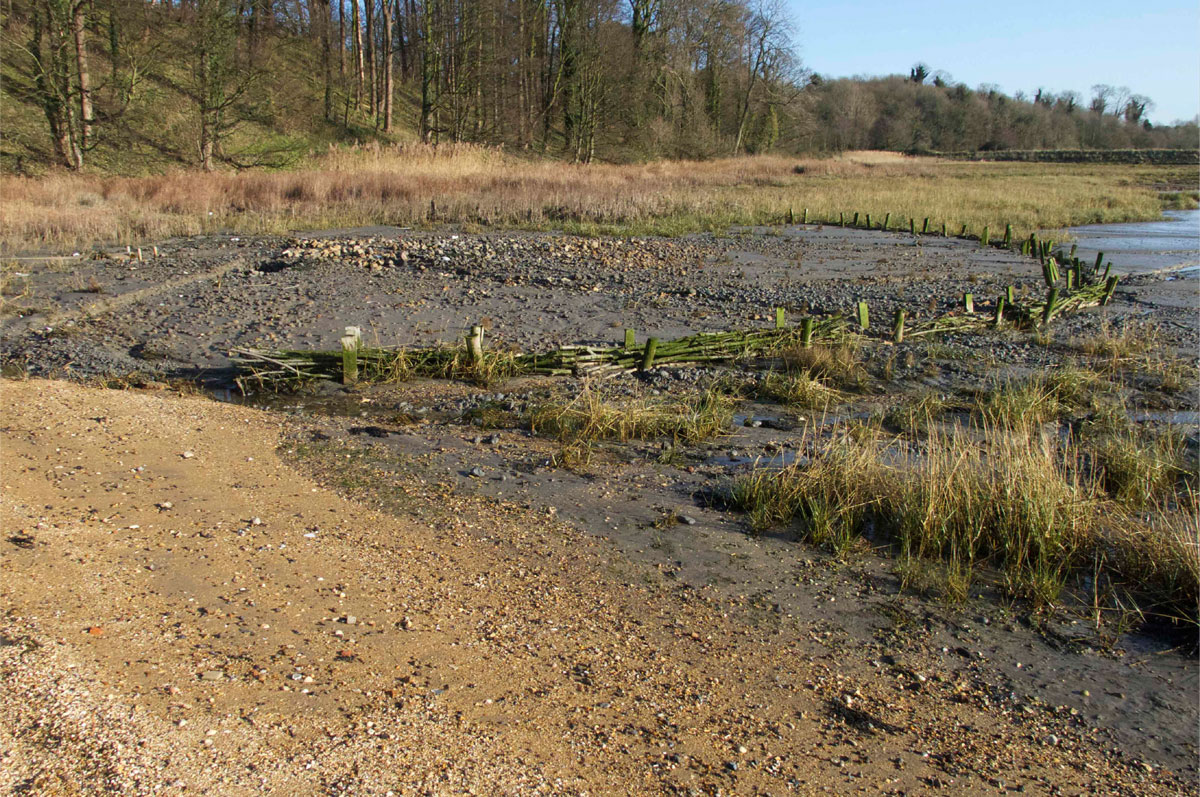
At present the state of the original sea defence wall is vestigial having eroded back to its riverstone core, no higher than high water neaps. The gradient of the site is oriented roughly northeast southwest; as a consequence it currently drains through two breaches, the main one at the southeast corner beside Loompit Lake and the other at the centre. The strategy for managing the discharge of dredging spoil within the site is threefold:
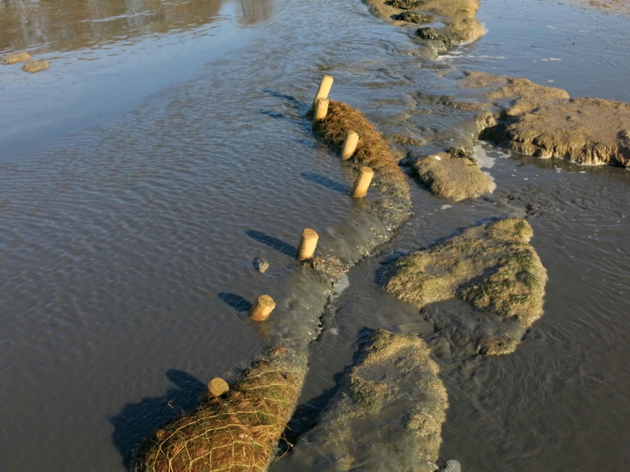
- Block the two main breaches in the original defence wall to ensure that the spoil will not be carried out directly into the tideway and that tidal exchange within the site will be controlled.
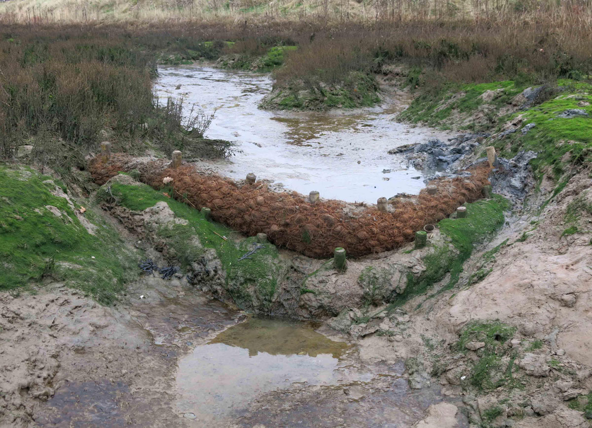
- Construct a pen of brushwood backed up with coir logs using coir blanket around the outfall to mitigate the immediate effects of scour at point of impact.
- Construct a series of low bunds within the site to manage increased flow, discourage the tendency to form substantial drain channels and to encourage deposition as evenly as possible across the site. This is a low-key intervention using coir logs similarly to how they were deployed on the north marsh.
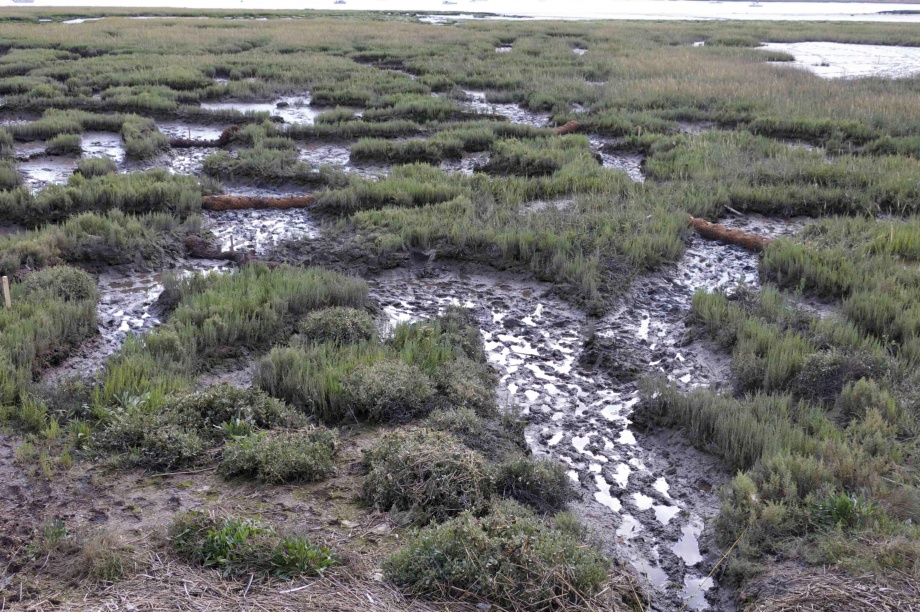
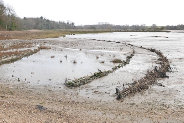
Loompit Lake site reversed to highlight mudflats and channel system
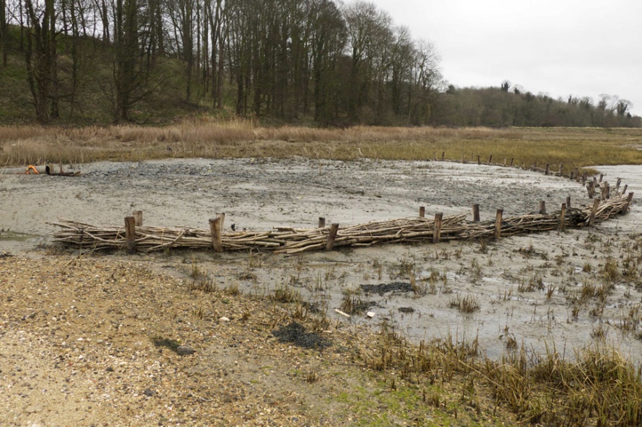

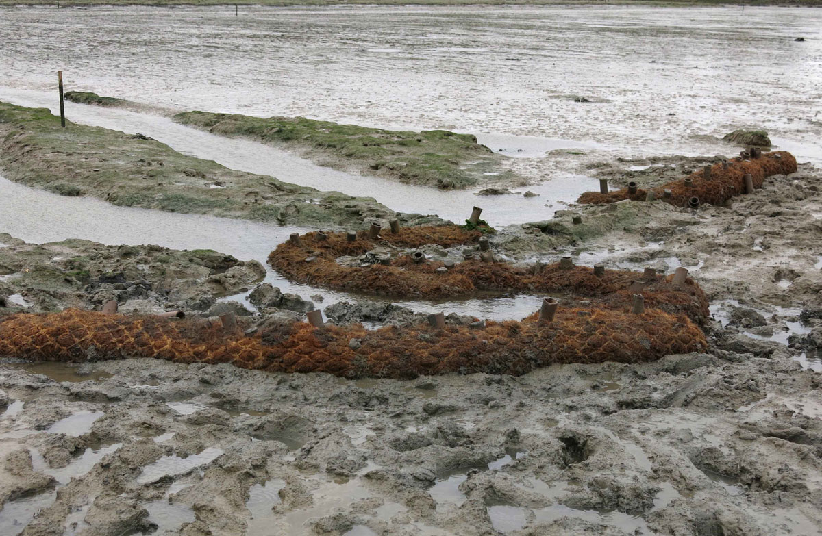
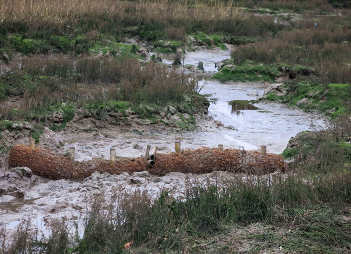
Location of Coir Logs and bunds on the Loompit Site
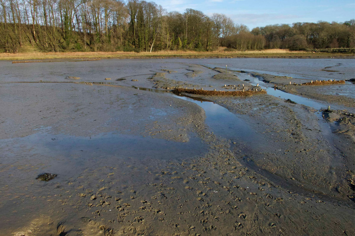
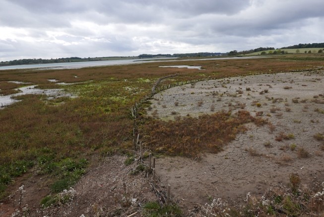
After the completion of the dredging operation at the Loompit Lake site, it became clear that the bunds that had been put in place had been effective in retaining sediment within the site and ensuring that the existing channel systems were not scoured deeper.
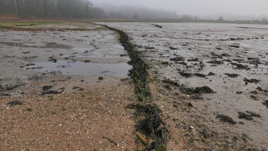
Once the sediment has settled, it will become clearer whether or not further work will be needed on the site before the next season.

Loompit Lake site after the completion of dredging operation. March 2015. Copyright: Simon Read
There may be a tendency for alternative channel systems to develop on the both East and West sites, however, it is agreed to wait until after the completion of the dredging operation for the current year before deciding upon whether it will be appropriate to install further adaptive measures.
Recommendations and Conclusions:
- Use of dredged material beneficially to enhance degraded marsh areas is a technique that can be used relatively cheaply by local marine businesses.
- Innovative materials like coir can be employed alongside traditional brushwood polders in the marine environment to provide structures to trap sediment and retain dredged material in situ.
- Partnership working is key to maximise design expertise and funding and gain permissions and consents.
Suffolk Wildlife Trust will be monitoring the project but initial findings (March 2015) are encouraging and the intertidal areas are trapping the dredged sediment successfully.
This project is a pilot and case study for the Essex and South Suffolk SMP and will be part of a strategic Beneficial Use of Dredgings Strategy being led by the Environment Agency.
Both Suffolk Yacht Harbour and the Beneficial Use of Dredgings Startegy project will report back to the Essex and Suffolk Coastal Forums to encourage buy-in from statutory and non-statutory organisations and highlight the benefits of this technique for marine businesses and the local environment.
Acknowledgements:
Thanks go to Trazar Astley Reid as the Suffolk Estuaries Officer working for the SCHU who advised Stour and Orwell Estuary Management Group, along with Jonathan Dyke as owner of Suffolk Yacht Harbour for hosting a pilot project at Marina. Thanks also to Karen Thomas (Environment Agency) who gave expertise to develop the design of the sites and Emma Hay (Natural England) for supporting the approach.
Thanks to Simon Read and Kieron O’Mahony for designing and installing the structures and to Dorothy Casey and Andrew Excell of Suffolk Wildlife Trust for agreeing to works on their land, undertaking the monitoring programme and giving enthusiastic support throughout the development of the project. Carol Reed for giving technical advice and support on the viability of the project and John Brien of Harwich Harbour Authority for giving support over the dredging license protocol.
Thanks also to the funders which in addition to Suffolk Yacht Harbour were; AONB Sustainable Development Fund, VEOLIA, Environment Agency, Suffolk Coastal District Council, Suffolk County Council, ABP Ipswich, Ipswich Borough Council, Suffolk Wildlife Trust.
References:
Stour and Orwell Estuaries Management Group. Management Scheme and management strategy: http://www.suffolkcoastandheaths.org/projects-and-partnerships/stour-and-orwell-estuaries-management-group/
Stour & Orwell Estuaries Management Group working in Partnership with Suffolk Yacht Harbour: Levington Saltmarsh Restoration & Beneficial Use of Dredgings Project 2013.
Produced and updated by Trazar Astley-Reid Suffolk Estuaries Officer for the Stour & Orwell Estuaries Management Group May 2014
“Maintenance Dredging Protocol Baseline Document”. Harwich Harbour Authority: http://apps.hha.co.uk/library/files/F03C8865-664E-409F-A6E8-4F4BEC761C66.PDF
South Suffolk and Essex Shoreline Management Plan: http://www.eacg.org.uk/docs/smp8/essex&southsuffolk%20smp%20final%202.4.pdf
Simon Read, Associate Professor, Middlesex University London.
Report February 2016
Saltmarsh management scheme, further maintenance work 2015/2016
Report prepared by Simon Read
The original project 2014/15:
Over the winter of 2014/2015 contracted works were carried out by Kieran O’Mahoney, Simon Read and Allden Owles to prepare two sites adjacent to Suffolk Yacht Harbour to receive and retain pumped dredging spoil. The sites are to the west of the marina on the fringing saltmarsh adjacent to Levington Creek and to the east on the high mudflat behind the historically breached defence wall beside Loompit Lake. The approach to this work was to locate a system of low coir bunds on each site to retain spoil but not interrupt the drainage.
Since initially neither site held any saltmarsh features higher than approximately 30-50cm above bed level, it was decided to keep the intervention to a minimal scale upon the understanding that over subsequent years, as levels increase there would be a need to revisit and introduce or extend the works already in place. It was agreed that following the success of the 2014/2015 further adaptive works would be justified.
At the Levington Creek site, a system of coir bunds was installed in the channels radiating from the discharge point and a shuttering ply pad staked in to mitigate scour immediately beneath the outfall. Upon the completion of the dredging work these channels had for the greater part filled with sediment and after a year there is evidence of pioneer vegetation in the form of Samphire (Salicorna Europaea).
The Loompit Lake site is fundamentally unrelieved mudflat where the strategy was to use lines of coir to encourage the spread of sediment across the surface as much as possible and to impede the tendency for substantial drain channels to form. For this reason a holding pen of brushwood and coir logs was constructed at approximately 30m radius from the discharge point and a coir mat inserted to mitigate the immediate effect of scour. After the dredging operation, it was clear that the coir barriers had all retained substantial amounts of silt and that the holding pen had filled up completely and within a year was becoming colonized by Cordgrass (Spartina Anglica).
Further adaptive work 2015/2016:
At the time of the original project 2014/2015 it was understood that it would probably require revisiting the next year to extend its efficacy by introducing further structural works. It was anticipated that again this would be low key and no more than a extension what has already taken place as an adaptive and responsive process.
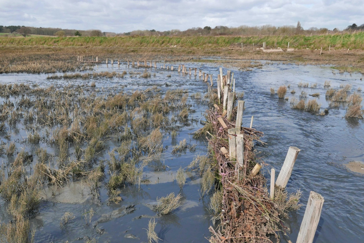
The East Marsh at Loompit Lake has a substantial accumulation of sediment prompting the approach to do no more than extend the effect of the previous works by continuing the coir logs already in place outwards to contain overspill and the tendency of new drain channels to form. Whilst it is understood that channels will form because of the north west-south east gradient, the aim is to encourage a terracing effect where possible, with the intention to raise the elevation of the site overall to encourage vegetation succession. 18 coir logs were installed on this site over a period of two days.
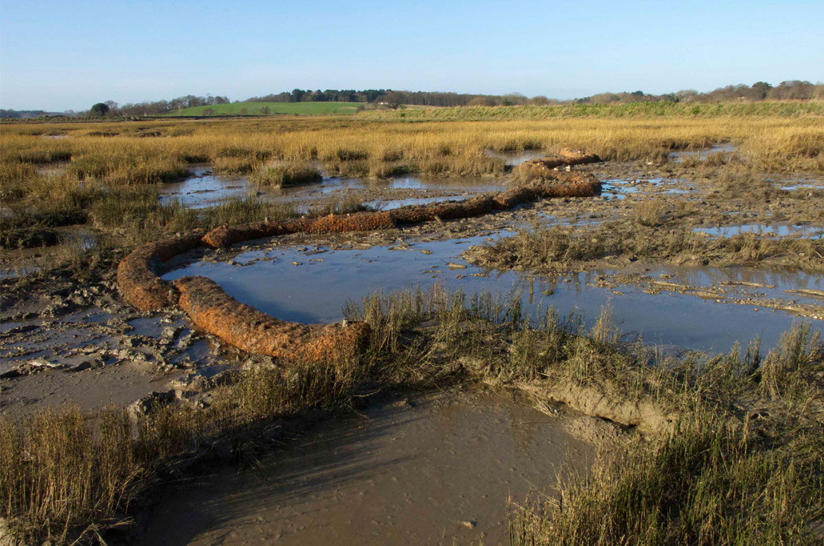
Further extension of coir barriers at Loompit, November 2016. Simon Read
For the West Marsh adjacent to Levington Creek the strategy was to manage the most substantial channels that have formed as runoff from the previous years dredging operation, extend the capacity of the marsh to retain sediment further out from the point of discharge, encourage the formation of a higher level of sediment to be captured by an undulating line of coir coir logs set at a radius from the discharge point of approximately 20-30 metres. 20 coir logs were set aside for this work and were installed over 15th-16th January 2016.
Further works to raise levels and to manage drainage channels where necessary
Recommendations and conclusions:
It has been established that it is possible, through low-key intervention upon two different degraded saltmarsh sites, to retain dredged spoil and effectively raise their level and resilience.
- On the Levington Creek site the accumulation of silt in the drain channel areas is up to 30cm, whilst closer to the discharge point the surface level has been raised by approx 10+cm.
- On the Loompit site the accumulation of silt at the discharge pen is up to the top of the brushwood. An estimated 10cm is laying on the surface overall but towards the river particularly at the two original drain points the depth of soft mud is considerable and up to 40cm at its most extreme and 20cm where it is held by the coir barriers.
- At the time of writing, it is clear that the Loompit site is gathering sediment well to the extent that some has washed behind the outfall into the marsh behind the sandbank. As a result of this some further drain channels have formed.
- On both sites there is localized evidence of pioneer vegetation.
- The muds that have been deposited are still soft and not sufficiently anchored not to be washed away, on this basis the use of low-key structural intervention may continue to be necessary before they stabilize. At the time of writing, the performance of the marsh at Levington Creek has not been observed since the dredging operation is still in progress.
Observations:
Although it may be feasible in the future to continue to push sediment around on the Loompit site it may more effective to move to a combination of brushwood and coir to further raise levels at the Levington Creek site in order to propogate vegetation and develop succession.
I suggest we review and assess both sites before the next round of dredging to whether further work should be carried out and if so, what form this would take. If taken on the basis of the work already undertaken any intervention should be minimal.
Holding Pen and coir logs towards the bottom of the site after dredging Jan 2016
Preparatory work for Suffolk Yacht Harbour dredging operation 2016-2017.
Locations:
The two locations to be worked upon were the mudflat immediately to the south east of the yacht harbor, adjacent to Loompit Lake and the fringing saltmarsh complex north west of the yacht harbor, adjacent to Levington Creek.
Building upon the works already carried out on both sites:
- It was agreed to make minimal intervention at the Loompit site beyond extending the baffle system already in place where appropriate and to put in place a further section of brushwood fence to extend the discharge pen. We also agreed to raise the level of the outfall with the intention that the distribution of sediment should reach beyond the immediate point of discharge.
- At the Levington Creek site, the strategy of placing coir logs within the channel system where it radiates outwards from the outfall has been so successful that the channels up to and beyond 30 metres have become so filled with dredged spoil that they are beginning to develop pioneer growth of Samphire (Salicornia) and Cord Grass (Spartina Anglica). As a consequence, we agreed to put in place a low brushwood pen in an arc, 30 metres from discharge point with the aim of raising levels overall, with the intention of encouraging the establishment of high marsh closer to the seawall and, from there, gradually work outwards into the body of the marsh.
- We also agreed to extend the use of coir logs in the channel system further into the body of the marsh where appropriate and where it would be beneficial to back up those already in place from previous years.
Work carried out:
The work at the Loompit site was carried out over Saturday 19th November laying out 8 coir logs to extend the current configuration and a low brushwood fence in an arc between the current holding pen and the existing sandbank to attenuate increased outflow and scour.
Our strategy for this site was to respond in a minimal way to the pattern of flow across the site that has altered since the dredging operation of the previous year.
Our strategy for this site was to respond in a minimal way to the pattern of flow across the site that has altered since the dredging operation of the previous year.
The further work at the Levington Creek site took place over three days 10th-12th December. The brushwood faggots were regrettably inferior quality, but were adequate to provide a low barrier contiguous to the surface of the mud deposited from the previous year. Provision was made to raise levels further in subsequent dredging operations.
21 coir logs were used to raise sediment levels in the drain channels and to extend the effect to the edge of the main drain for the system, improving the capability of the system to retain the dredged spoil.
Observations:
It is clear on both sites that levels of sediment are being held and that there is considerable evidence of new pioneer growth, consisting mainly of Samphire and cord grass.
At the Loompit Site we might need to reconsider the position of the outfall since it has built up so much spoil that it is beginning to flow back into the marsh behind the sandbank. This may not be a problem but it does mean that the outflow is becoming not so direct into the receptor site.
The barriers put in place at two locations in the original river wall have become dislodged by wave action this season and may need some attention before next year.
The Levington Creek site may need some reconsideration next season. Whilst the principle of working from the inside outwards is very successful and levels have been raised considerably, it may now be appropriate to place a brushwood structure in the main drain channel area.
We have also noted that where coir logs had been put in place in positions furthest from the outfall, these have been overtaken by erosion caused by wave action due to exposure to fetch from the river. This may benefit from an attenuation barrier, but will need careful consideration in order not to promote further scour or be overtaken itself.
Future Works:
The strategy for the Loompit Site is functioning very well and holding sediment well. My recommendation would be to continue to adapt to the shifting channel system on the site through low-key intervention using coir. However, as the holding pen and its present extension become overwhelmed with sediment, further brushwood may become more necessary to raise levels.
Any further intervention should be subject to reassessment in the summer of 2017.
Whilst the Levington Creek site is working well from the inside outwards into the body of the marsh and I am happy to continue with this basic approach, it has become clear that the marsh continues to degrade at its outer limit where it is more vulnerable to estuary systems, wave action and wash. Mitigation for this will need careful consideration.
This also will need consideration over the coming months and as already proposed, more substantial structures may be appropriate as the work extends further into the body of the marsh and the larger channel systems.
SUFFOLK YACHT HARBOUR: the beneficial use of dredging spoil
A Summary of the Project 2013-2018
The background against which this project was developed was the recognition of the landscape and habitat value of the Stour and Orwell Estuaries, combined with the need for Suffolk Yacht Harbour to conduct an annual dredging operation to keep its floating moorings free of silt.
Before giving an account of the operation, it may be helpful to reiterate the initial account of the features of the location when the project was planned in 2013:
The Stour and Orwell estuaries are recognised as being of national and international importance for their nature conservation value. The estuaries
include extensive mudflats, low cliffs, saltmarsh and small areas of vegetated shingle. The mudflats and areas of saltmarsh provide feeding grounds and roosting habitat for large numbers of wintering and passage waders and wildfowl and also support nationally scarce saltmarsh plants and invertebrate species. The hinterland comprises important areas of open farmland, parks and woodland, all of which provide a rich diversity of habitats and wildlife including a variety of Red Data Book species.The estuaries, although treated as one entity for the purposes of the Habitats Regulations, have very different characteristics in terms of bird populations and habitats. The average number of waterfowl found on the Orwell is around 17,000, whereas on the Stour there are typically around 48,000 birds in winter months (data from WeBS counts).
In the past, land claimed for agriculture and commercial development has led to the loss and change of intertidal habitats, with some parts of the estuaries accreting and others eroding. The Stour and Orwell estuaries are designated a Special Protection Area (SPA) under the EC Birds Directive because they support internationally important numbers of waders and wildfowl. The estuaries also qualify as a Ramsar site under the Ramsar Convention (1971), which aims to promote the conservation of wetlands.
The Stour Estuary, the Orwell Estuary and Landguard Common are Sites of Special Scientific Interest (SSSIs) designated under the Wildlife & Countryside Act (1981). Most of the estuaries (excluding the south side of the Stour) are part of the Suffolk Coast and Heaths Area of Outstanding Natural Beauty.
1.2 Interest features and conservation objectives of the Stour & Orwell estuaries
The interest features and conservation objectives of the Stour and Orwell SPA are detailed in the Natural England document: English Nature’s advice given under Regulation 33(2) of the Conservation (Natural Habitats) Regulations 1994 – Stour and Orwell Estuary: European Marine Site. Issued 23 January 2001. The Conservation Objectives for the site can be summarised as:
Subject to natural change, to maintain in favourable condition the habitats for both the internationally important populations of the regularly occurring Annex 1 bird species and the regularly occurring migratory bird species under the Birds Directive – in particular the inter-tidal mudflat and the saltmarsh.
In this context, ‘favourable condition’ means the maintenance of the geomorphological form and functioning of the estuaries, so that they are capable of sustaining the populations of internationally and nationally important birds for which the site qualifies.
Produced by: Trazar Astley-Reid Suffolk Estuaries Officer; for the Stour & Orwell Estuaries Management Group
December 2012
In 1997 and 2001 the qualification of the Stour and Orwell Estuaries SPA was as follows:Populations of internationally / nationally important over-wintering birds, based on:
- Notable numbers of golden plover (under Article 4.1);
- Important populations of dunlin; shelduck; dark-bellied geese; redshank; grey plover; black-tailed godwit; turnstone; ringed plover; wigeon; knot; curlew; pintail; mute swans; goldeneye and scaup (under Article 4.2).
However, in 2003 the boundaries of the constituent SSSIs were extended and in May 2005, the SPA boundary was extended to include an additional 360 hectares. Following the re-notification of SSSI’s in 2003 and the SPA in 2005, the site now qualifies under Article 4.1 of the Wild Birds Directive (79/409/EEC) by supporting 1% or more of the Great Britain population of avocet (Recurvirostra avosetta). Over the period 1996 to 2000 the SPA supported 21 breeding pairs. It also qualifies under Article 4.2 of the Directive as it is used regularly by 1% or more of the bio-geographical populations of a number of migratory species (other than those listed in Annex I to the Directive), as summarised in Table 9.1.
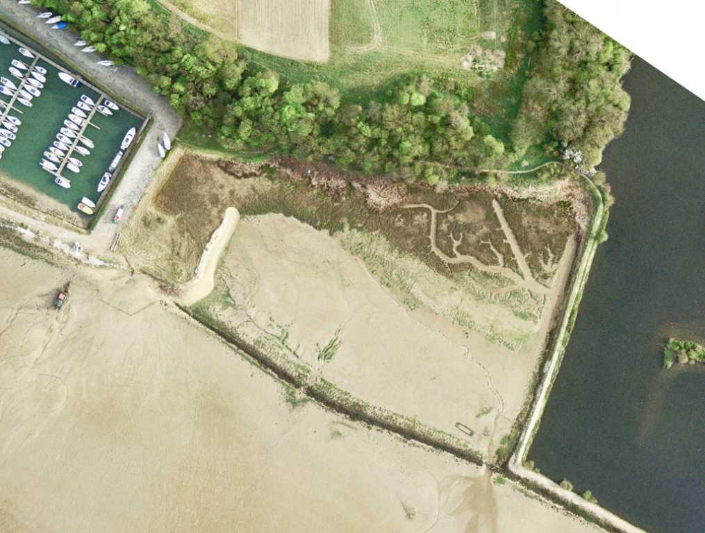
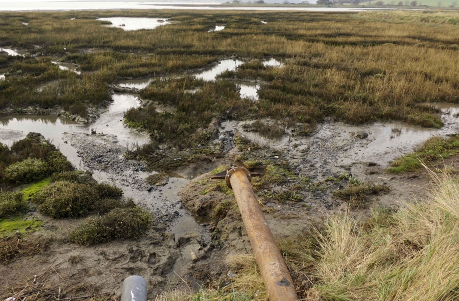
Every year, Suffolk Yacht Harbour needs to dispose of up to 20,000m3 of dredging spoil. In 2013, a licence was granted to use receptor sites additional to those already in use on the foreshore to the east end of the harbour and directly to the west of the harbour entrance. These two new sites are an area to the East of the Yacht Harbour adjacent to an artificial lake, Loompit Lake and a section of the saltmarsh to the West, between the Yacht Harbour and Levington Creek. Although the original foreshore sites remain perfectly viable, it was agreed to treat the new receptor sites as a specific project, structurally preparing them in advance to receive pumped spoil and to manage its flow in such a way as to ensure that it provides maximum recharge value for two areas of saltmarsh that had become severely depleted.
Since its initiation in 2014, this project has progressed well over four years and although over this period a substantial amount of dredged material has been successful retained on site and monitoring has shown that levels have risen consistently, it will take longer for pioneer vegetation to become thoroughly established and for succession to be secured.
The New Receptor Sites:
The two identified receptor sites for spoil are essentially dissimilar and although the materials have so far remained consistent across the whole project, each site imposes its own conditions upon the strategy for containing sediment.
1. Loompit Lake Site
Once reclaimed farmland, this is now an area of mudflat and vestigial saltmarsh of approximately 5 hectares bounded to the east by Loompit Lake, an artificial lake created behind the river defence wall, to the west by the yacht harbour and retained to the south by the derelict rock revetment of the failed defence wall. The site has a natural gradient, roughly on a northwest southeast axis; to the north it remains close to the level it was when it was farmed and rises to the wooded slope of the coastal plateau. To the west and adjacent to the marina there is an interesting sand bar formation that is evidently the fall out of material from the time that the spoil was discharged directly into a holding pen on the immediate foreshore and when heavier material was drawn down and deposited by the tide.
At the start of the project, the character of the mudflat was largely undifferentiated with channels forming to reflect the gradient of the site and exiting at two key locations: towards the centre of the redundant floodwall and at the furthest south east corner of the site where the fresh water overflow from Loompit Lake is located and where this combines with a freshwater spring from the north east corner of the site.
The principle vegetation on the site ranges from sea purslane halimione portulacoides and shrubby sea blight sueda fruticosa in the sheltered area between the sand bar and the marina to cord grass spartina anglica, sea aster aster tripolium and some purslane colonizing the higher levels of the old pasture beneath the woods. Where there is a mixture of salt and fresh drainage at the higher levels, there are stands of common reed phragmites australis.
1a. Response to the site:
This was based upon its perceived characteristics, which are the gradient and natural drainage of the site coupled with a need to prevent excessive loss of material via the two weak points in the derelict wall, towards its centre and to the southeast corner.
From the start it was realized that the project must remain sensitive to how the flow of the sediment responds to intervention, and to continue to act in an adaptive way over consecutive years. Since every year a considerable amount of material is deposited, it is predictable that some structures will become buried and new configurations of flow across the site will form. This in turn has prompted a conversation with the behaviour of the site on a year-by-year basis.
1b. Materials:
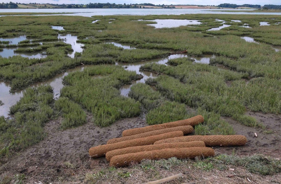
- Coir logs 300mm/3m
- Coir blanket
- Brushwood bundles 300mm/2m
- 1.2m softwood stakes
1c. Method:
Build up the lowest drainage points in the derelict perimeter wall to approximate the average wall height.
Position the discharge point at the highest point of the site at its northwest corner. Stake down a coir blanket to prevent excessive scour due to the impact of high velocity discharge of spoil.
Construct a low holding pen of brushwood to contain heavy spoil and attenuate flow of liquid slurry across the site.
Manage the existing drainage channels using coir logs to hold sediment, divert flow and promote an equal distribution of material across the site.
1d. Responding to change:
In parallel with the incremental accumulation of sediment through the duration of the project, it has become vital to keep an adaptive approach. The use of materials has remained consistent and the principle of exploiting gradient and interrupting flow through the use of coir logs has so far worked well to distribute material evenly.
When, within the first two years, the original brushwood holding pen structure became overwhelmed with sediment, we raised its level to retain more. Over the following years we have raised the discharge point and moved it further into the site as a response to the accumulation of solid material above the crest level of the adjacent salt marsh.
Correspondingly, we have created a new brushwood holding pen further out in the site and concentric to the original one that had since become buried. Since the relative heights of the existing marsh and the bed level of the mudflat was no more than 300mm, we agreed that there would be nothing to gain by putting higher structures in place and that we should concentrate upon incrementally raising levels across the whole site to the point where pioneer growth might establish.
1e. Observations:
When we embarked on this project, we agreed that it would be long term and that there may be little appreciable change within its early years. However this is its fourth year and it is clear that the Loompit site has successfully retained sediment and that the strategy of making minor adjustments each year to facilitate an even accumulation of material has been successful.
Since the beginning of the project there are some new stands of cord grass on the higher levels close to the sand bank and a more considerable accumulation close to the discharge point. There is also some colonization by samphire salicornia perennis in the area downstream from the holding pen. Although the bed level of the mudflat has become close to the older colonized area, this is insufficient to promote colonization so far.
This site is a feeding ground for brent geese and other wildfowl such as teal and wigeon. It is both feeding ground and high roost area for familiar wading birds such as redshank, curlew and black tailed godwit. It is also worthwhile noting that little ringed plover have nested on the sandy/gravelly areas above and around the sandbank at the western boundary of the site.
1f. Future action:
For this site, so long as the sediments continue to accumulate and a point is reached where colonization by saltmarsh vegetation becomes more comprehensive, we recommend continuing with the current strategy. It is clear that the build up of sediments in some parts of the site will dictate the need to shift attention to other areas and also to shift the position of the discharge. This is in the nature of the project and is evidence that we are not working with “once and for all” solutions and that to enjoy any success it needs to be an adaptive and iterative process.

2. Levington Creek site
This differs substantially from the Loompit site: it is an open area of fringing saltmarsh backed by a sea defence wall and exposed to the effects of tidal scour, fetch and wash. This is an old and established saltmarsh site that has become severely degraded, particularly around its outer perimeter where it is severely eroded and suffers from loss of vegetation. Where it is most exposed it has become deprived of any resilience to wave and tidal action.
The system of the marsh is fundamentally consistent with that of any fringing saltmarsh: it has a typically dendritic pattern of channels radiating from large drains running into the body of the marsh. However, these channels have become complex and multiple where they are constrained by the flood defence wall; this is possibly due to amount of water carried into the site by the tide and the corresponding evolution of complex capillary structures to contain and dissipate tidal energy. This has most likely contributed to the incremental breakdown of the saltmarsh from the inside.
At first sight this is a well-vegetated marsh, but it is predominantly a monoculture of cord grass on both the outer and inner marsh with occasional sea aster. Closer to the wall where drainage is good, there are stands of purslane and standard saltmarsh succession clings where the marsh rises to the sea wall. Where there is low tidal energy the creeks have become well colonized by Samphire.
2a. Response to the site:
Given that much of the stress upon the site is caused from the inside by the sheer volume of the tidal exchange and the expansion of the channel system to contain it, we decided to start work from the inside outwards. It was agreed that the delivery point for the discharge should be via an existing drain in the defence wall just before the lagoon areas managed by Suffolk Wildlife Trust. This does not quite sit at an intermediate point between two major creek systems with the effect that drainage is inclined to follow the gradient to the south.
As at the Loompit site we needed to ensure that pumped sediments should be captured within the channel system to not only raise the overall level of the site, but also to fill the extensive capillaries of the creek system.
In a similar strategy to that applied to the Loompit site, we agreed to operate at a responsive level, preparing the site in the first instance to train the entrapment and flow of sediments and by adapting to its evolution over the following years.
2b. Materials:
Consistent with the Loompit site, we used a combination of brushwood bundles 300mm/2m and coir logs 300mm/3m, all put in place using 1.2m stakes. The brushwood bundles were only put in place as a holding pen in 2016/2017.
To absorb the impact of the discharge we fixed an 8ft/4ft ply board beneath the outfall.
2c. Method:
Prepare the creek system with coir logs to entrap and train sediments before they reach the main drain channels.
Construct a holding pen of brushwood around the discharge point, to capture heavy sediments and to attenuate the flow of liquid slurry across the site for 2016/2017 and 2017/2018 seasons.
2d. Responding to change:
As with the Loompit site it is certain that some of the system will fill up with sediment whilst other channels may receive very little. This may be caused by nuances in gradient or simply that the flow develops a trend that favours one direction over the other. However the site has behaved as a result of each year’s dredge gives clues for how to prepare for the next year, whether it is favourable to install structures further out in the system or to manage those areas that the flow of sediment may have by-passed. In all events the aim is to work outwards from the holding pen to raise levels through the site as far as the main drain channels and eventually to lower the tidal exchange overall.
As the site has accumulated more sediment, it has become necessary to extend the holding pen and this year, 2017/2018, to raise it by a further layer of brushwood. During the campaign of 2016/2017, the level of sediment around the outfall rose by more than a metre. The result of this is that although the muds remained very soft most of original drain channels within about 40metres of the holding pen have become overwhelmed.
Although we prepared the same creek system to receive more sediment this year, we realize that now is the time to allow the site to settle and hopefully stabilize and next year to direct discharge towards the neighbouring creek system that trends more to the north. In order to do this, it will be necessary to extend the pipework northwest parallel to the floodwall by approximately 100metres. Ideally this will encourage more drainage towards the northern section of the site where the effects of erosion have become extreme.
There has been some discussion over whether there may be benefit in putting in place structures to attenuate wave action on the outward fringes of the marsh where they are exposed to fetch and tidal scour. Since they would be under constant stress, it is not appropriate that they should be of the same material as within the more sheltered body of the marsh. This will need further discussion but the inclination at present is to consider low timber structures to act as wave breaks or as training walls. Although this is a distinct departure from our philosophy so far to work from the inside outwards, it is driven by the worrying increase in erosion and loss of vegetation that reaches well into the body of the marsh and may need to be developed further for the coming season.
2e. Observations:
As at the Loompit site this is a long-term project. Although there have been some immediate changes and in terms of sediment retention the project has been dramatically successful, apart from where there are some residual patches of samphire, the rapid build up of material has not permitted the vegetation to catch up and recolonise. For this reason we suggest shifting attention further north for the time being to give the site a rest and a chance to recolonize.
Because this is an exposed site, there is a marked discrepancy between material gained within the sheltered core of the marsh and loss of material at its outer fringes. Evidence of this is in the monitoring carried out over 2016/2017 by Suffolk Wildlife Trust.
Although there is consistency between the two sites for bird life, there are some differences such as the presence of snipe and of teal feeding on the shoreward fringes.
2f. Future action:
As has been established the Levington Creek site is different and possibly more complex than the Loompit Lake site. Because of the breadth of the site and the range of drain channels, It does not easily respond to the delivery of spoil from one discharge point only, and since it is open to the estuary it is vulnerable to wave and tidal action that could possibly reverse the careful preparatory work undertaken within the body of the marsh.
As a long-term project mutual benefit may need to be explored between its vulnerability from estuary and the sea and the coastal squeeze effect upon succession of saltmarsh vegetation inside the marsh. However, since this site is in receipt of up to and frequently beyond 10,000m3 of spoil per annum, it has a greater chance of revival than other sites that rely upon the sediment in the tidal system alone.
As it stands the marsh delivers protection to the flood defence wall against wave and tidal action and is likely to do so for a long time yet. The use of pumped sediment will continue to underpin the resilience of the wall as a natural flood defence, but there will be a need to consider its seaward face and whether safeguards may be effectively put in place against wash and wave action.
3. Conclusions:
Although the underlying motive for this project is to restore and enhance saltmarsh habitat, it is important not to lose sight of its primary aim, which is to annually manage and sequester a large amount of dredging spoil. The receptor sites are already sensitive habitats where an appreciation of their vulnerability has made them suitable candidates for a recharge exercise. The decision that this should not be a once and for all solution is based upon the need to respond and adapt to the behaviour of each site on a year by year basis.
In this respect, low-key, biodegradable interventions are feasible, since once their purpose has been realized they are likely to have become buried in spoil and the flow diverted elsewhere on the site. This has become an iterative process where the placement of materials one year, sets up a reaction that prompts the decisions for the following year.
It is certain that projects such as this take a long time to show an appreciable difference and may not even work in a predictable way. However, whatever happens, they make a difference and are examples for how a symbiotic approach to sediment management and habitat creation can work.
Coir Logs installed, Levington Creek site 2018
Coir Logs during dredging, Loompit Lake site 2018
Preparations for dredging operations 2018-2019
As agreed we have undertaken the management of two receptor sites at Suffolk Yacht Harbour in preparation for the annual dredging operation. This is the 5th annual intervention carried out at the Loompit Lake site to the east of the yacht harbour and on the saltings immediately to the west and east of Levington Creek.
The materials routinely deployed are brushwood bundles to construct initial holding areas for fluid sediment in combination with coir logs staked into the channel system to encourage sediment to settle and to prevent it returning directly to the tidal system.
The strategy each year is to respond adaptively to the behaviour of the pumped spoil driven by the attenuating structures set out the previous year. Given that the annual dredge is circa 15000-20,000 cubic metres distributed between two sites, it is predictable that the level of retained material may reach the capacity of the structures put in place each year, prompting the need for a responsive approach to laying out new structures or extending those already in place over subsequent years.
Although the material used for both sites is consistent, their disposition is determined by the particular characteristics of each site: the Loompit Lake site is a historically failed reclamation site that has reverted to mudflat, whilst the site to the west is an existing but depleting fringing saltmarsh which retains its original but fragmenting drain channel system.
Loompit Lake Site:
Spoil has been pumped into this site from a location at its north west corner for which a D shaped holding area has been put in place using brushwood. Over the years this holding area has been incrementally expanded as the level of material has increased sufficiently to promote pioneer vegetation. Over previous years this was predominantly spartina anglica, but through 2017/18 there was an abundance of salicornia.
The flow of fluid sediment across the site is fundamentally in a north westerly to south easterly direction corresponding to the slight gradient. In order that sediment becomes distributed across the site as evenly as possible, this is entrained by lines of coir logs staked in to inhibit the formation of distinct drainage channels and a corresponding loss of material back to the estuary.
Year on year we have taken an adaptive strategy to the placement of attenuating structures to hold sediment. This year we can see that there may be justification to change the strategy slightly to allow the attenuation structures to join up to create a terrace form at the higher elevation but continue to act in a responsive fashion to arbitrary shifts of flow in the lower areas towards the south east. In this way I suggest breaking the site down to two distinct zones.
Levington Creek Site:
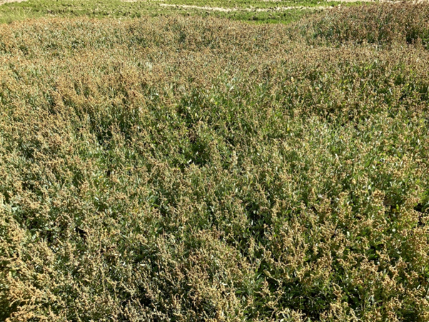
Since this project began, the accumulation of spoil towards the landward side of the site has been considerable, increasing by 1.5m locally close to the outfall and held by a brushwood pen approximately 20m into the site. The endeavor to hold sediment in the drain channels using coir logs has been very successful and there is strong evidence of an increase in saltmarsh vegetation although this predominantly remains spartina anglica with some sea purslane at well drained higher elevations and in particular close to the sea wall.
Since the gradient of the site has encouraged flow of material towards the south east of the site, we have observed that the area west towards Levington Creek has continued to deplete. For this reason we arranged for the outfall to be moved further to the west and the brushwood pen extended in a westerly direction parallel with the sea wall in order to encourage flows to fill those areas that have been starved of sediment since the beginning of the project.
I am pleased to confirm that this experiment has been successful and should probably be built upon over the coming years.
We are also starting to set up attenuation structures within the main drain channel eastwards from the site.
It is of some concern however that the areas closer to the direct influence of the tidal river continue to lose vegetation cover and are subject to stress from wave action due to south westerly fetch and the effects of wash from passing shipping. We have in the past discussed putting in place wave deflection structures of boards and brushwood. Whilst this may be worthwhile experimenting with it is debatable how effective this is likely to be in such a dynamic location.
My suggestion is that the more the inside of this site can be consolidated, the more likely its beneficial influence may be felt at its periphery and that perhaps it will need to be accepted that there must be a degree of give and take along the outer edge of the marsh.
Future works:
Since over the past five years we have witnessed incremental accretion of dredged sediment on both receptor sites, it seems well to continue to follow an adaptive and responsive strategy for the foreseeable future. However, at the Levington Creek site there may be justification at some point to change the outfall location in order to give saltmarsh plants a better opportunity to colonise, since year on year any potential growth has been smothered by a new load of sediment.
For the Loompit site: aside from any adjustment to the organization of materials as discussed earlier, there seems little benefit in changing the location of the outfall other than bringing it further into the body of the site as it gradually backfills. Its current position works well with the north west/south east gradient of the site ensuring the potential to continue to regulate flow across the entire marsh.
I will visit both sites during the summer of 2019, when perhaps we can take the opportunity to discuss how we build on what we have so far accomplished.

Suffolk Yacht Harbour 2019-2020 saltmarsh management works
Over the last two dredging seasons we have continued to extend the structures that we have already put in place both at the Levington Creek site and at Loompit Lake. However, since these locations are quite different in character, we have accordingly continued adopt a dedicated approach to each site:
Loompit Lake
Since the beginning of our intervention at this site in 2014, we have adopted a strategy of a brushwood D shaped holding area close to the point of discharge to force the heavier sediments to drop out and form a raised area that should become stabilised by pioneer vegetation such as spartina anglica (cordgrass) and salicornia (samphire). For the remainder of the of the site, we have deployed coir logs to hold run off and encourage further deposition of sediment before allowing it to drain back into the estuary. Year on year we have added to the configuration of the coir logs where new drain channels have formed, which would otherwise cause the direct loss of spoil into the estuary.
Through the life of the project we have progressively moved the point of discharge further into the body of the site and gradually expanded the holding area, whilst continuing to interrupt sediment flow through the rest of the site through the distribution of coir logs.
For the season 2019/2020, we decided that the holding area in the north west corner of the site had served its purpose and that there would be little benefit in further extending it.
Instead, we proposed dividing the site diagonally with a brushwood structure running NE/SW to further consolidate the higher region of the marsh. For the remainder of the site we added more coir logs to attenuate flow and mitigate the loss of material to the estuary.
For the season 2020/2021, it was clear that the measures put in place for the previous year were operating well and the upper areas were accumulating well whilst the area behind the discharge had become heavily vegetated with large stands of spartina anglica, a scattering of suaeda vera (shrubby seablite), aster tripolium (sea aster), salicornia and halimione portulacoides (sea purslane).
Due to limitations imposed by Covid 19 we were unable to carry out additional work on-site this season but on the understanding that the amount of spoil to be deposited would be minimal and although unsatisfactory, the measures put in place for the previous season would continue to serve adequately well for this year.
Levington Creek site
Over the duration of the project and to accommodate increased levels of deposited material we have gradually extended the boundary of the holding area outwards from the point of discharge. As at the Loompit site, the holding area is bounded by a low brushwood fence, which usually becomes entirely covered by one season’s spoil. As a rule, the amounts deposited at each site vary annually with the larger share going to one site or the other on alternate years, which means levels may increase more some years than others. In the immediate vicinity of the Levington Creek outfall the level of sediment has increased by 1.5m overall, and the original complex of drain channels has filled completely with spoil.
For the 2019/2020 season the brushwood fence was extended westwards as a training wall to encourage sediment feed towards depleted areas in the direction of Levington Creek
As at the Loompit site coir logs have been placed in the substantial drain channels to prevent the loss of material directly to the estuary. This has operated so successfully that for the 2019/2020 season the placing of coir was carried out with severe difficulty and even though it was possible to extend their impact further into the body of the marsh, their weight combined with the softness of the accumulated spoil made it very difficult to operate. It was decided that in future it would be impractical to continue using coir on this site and that more would be accomplished using brushwood to extend the holding area and create training walls to direct flow.
For the 2020/2021 season we continued extending the brushwood structure further into the body of the marsh and westwards towards Levington Creek. Whilst acknowledging that there is little that can be done structurally to stabilise the outward fringes of the marsh and to combat wave action, wash and tidal scour, we consider our best strategy is to work from the inside to create the bulk to grow the site so that eventually it will establish its own edge. Although there is an ongoing proposal to boost the marsh using dredged spoil from Felixstowe/Harwich, for now it appears that the best way to use the amount of sediment available annually is to incrementally restore and build the body of the marsh.
It appears that the project is succeeding in retaining spoil and whilst the entire area is becoming colonised by vigorous stands of cordgrass, pioneer samphire has become established on much of the newly deposited muds and around the coir bunds and raised channel areas. Sea purslane is abundant on the higher levels close to the sea wall. In the future, it may be beneficial to extend the outfall further west to direct more recharge towards Levington Creek. Coincidentally this will allow the newly sedimented areas to settle, recover and to establish a more comprehensive range of vegetation.
It should be noted that there is evidence of wave damage at the toe of the defence wall close to the discharge area for which a structure to attenuate wave action might be advisable.
Corroborating evidence
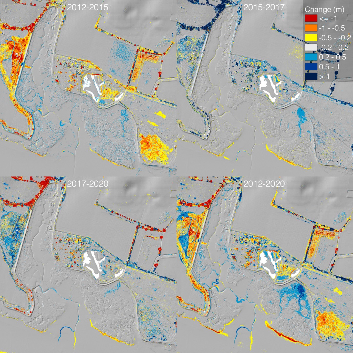
In a survey of 10th November 2020, Andrew Excell of Suffolk Wildlife Trust has confirmed that both the west and east sites are accreting. However, he has recorded evidence of erosion and loss of material due to tidal scour and wave action at the edge of the west marsh (Levington Creek).
Below is the LIDAR analysis of the Levington Creek site for the period between 2012-2020, kindly supplied by Helene Burningham UCL. The accumulation of material radiating out from the source of discharge can clearly be seen as can the loss of peripheral material from the edge of the marsh most exposed to tidal and wave action.
Taken together this data confirms that the project is having a positive influence upon the site, but that there remain areas that are still under stress. It provides some useful clues over the direction we should take the structural intervention and in combination with our experience on the ground gives us a lead on a strategy for the coming years.
Simon Read, 25th April 2021
Suffolk Yacht Harbour: preparations for dredging 2021-2022
Loompit site:
This year SYH made the decision to concentrate mainly upon dredging the eastern section of the yacht harbour, with the effect that meaning that most of the spoil would be pumped into the Loompit site. With this in mind, we agreed to extend the holding area further out into the site with a continuous brushwood barrier mixed with the coir logs left over from the 2019 operation.
So far, we have adopted a strategy of placing coir barriers within the site responding to fluctuation of sediment flows from year to year and have gradually extended the brushwood holding pen closest to the discharge point outwards as deposition levels rise and the area starts to vegetate. Our suggestion this year was to put in place a single low barrier with the aim to consolidate the relationship between the evolving saltmarsh and mudflat. We will monitor how this has worked at the end of the season once the site has settled down, before deciding whether to build upon it or return to a more adaptive response by managing flow. I suspect that it will be a mixture of both.
Our decision over materials used this year has been heavily influenced by the constraints over supply of goods due to global and national transport limitations and by reflecting upon the need to seek more sustainable solutions that do not depend upon supplies of coir from Sri Lanka or even brushwood from other parts of the UK. With this in mind, we agreed to experiment with a small hazel coppice onsite, to see whether it could deliver enough material to make up around 50 x 3m brushwood bundles, which, combined with the remaining 21 x 3m coir logs would be sufficient to put in place a continuous 160metre barrier. Since the intention each year is to respond to and work with the distribution of sediment, the barrier is of just sufficient height to impede and influence material flow within the site. The standard diameter of the brushwood bundles and coir logs are approximately 300mm, which is ample to be augmented or extended over consecutive years as necessary.
Although the process of cutting out the hazel and bundling it, plus staking it out on site was very labour intensive, it is reassuring that, so long as coppice material continues to be locally available, the whole operation can be self-sufficient and as an exercising in sequestering carbon, is essentially carbon neutral.
Levington Creek site:
The 2020-21 dredging operation was concentrated upon the receptor site to the west of the marina close to Levington Creek. This has continued to accumulate spoil and our efforts have been focused upon training the flow of material further out into the body of the marsh and westwards towards Levington Creek. Whilst there is only minimal intention to pump into this site in early 2022, quite a substantial drain channel has opened – up where the brushwood put in place the previous year ends. We propose placing some further brushwood to extend the existing structure to dissipate the tidal flow to save having to give it more serious attention in the next season.
Since we started work on site in 2014, the levels closest to the discharge point have raised by 1.5metres and have increased substantially over the rest of the site. Until it has consolidated and become bound by saltmarsh vegetation it is very soft to walk upon, which means that although it is possible to venture out, it is not possible to do so carrying a heavy coir log. This has prompted the decision to work only with brushwood on this site for the time-being.
Carbon Capture:
When we started this work in 2014, it was in the context of growing critical concern over the loss of saltmarsh on coastal locations due to a range of factors, including incremental sea level rise, increased storm and wave damage, human intervention and water quality issues from increased agricultural run-off and sewerage introducing levels of nutrient into the system that it cannot cope with. Combined with increased UV and hot summers, these can promote algal blooms that can poison or smother the marsh. Although it has been known for a very long time, marshlands not only draw down carbon from the atmosphere, but they also sequester and store it; conversely a degrading marshland releases carbon back into the system.
Recently there has been a great deal of attention given to the beneficial functions of saltmarsh and therefore the immense value of creating new and restoring old marsh. Suffolk Yacht Harbour has been actively promoting this function since 2014 and as such It is a perfect model for a collaborative partnership with a commercial organisation towards ecological benefit. In truth, through the beneficial re-use of dredging spoil, SYH has been promoting the creation and retention of new wetland since it was founded in 1967 and has worked with Suffolk Wildlife Trust to generate and manage a mosaic of distinctive habitats,for which the current work is the most recent iteration of a scheme that has run for over 50 years.
The only difference now is the increased level of sensitivity to the responsibility to take a more proactive approach to environmental stewardship. It is significant that Suffolk Yacht Harbour was actively promoting the recycling of its dredging spoil to create new biodiverse wildlife habitat long before saltmarsh became enshrined in the European Habitats Directive in 1997. In respect of the creation, promotion, and protection of saltmarsh habitat, It may be worthwhile exploring, the potential for accreditation through membership of the Carbon Charter scheme.
Simon Read, 17th December 2021
Suffolk Yacht Harbour: Saltmarsh Management Scheme 2022-2023
Report and Recommendations:
For this year’s dredging operation, having decided against further use of coir rolls due to their weight and difficulty of carrying them over soft mud we used 90 x 300mm/3m brushwood bundles gathered over early autumn 2022 and new year 2023 from hazel coppice harvested in Ufford.
East marsh at Loompit Lake:
Since the intention for the 2021-2022 season was to deposit a minimal amount of spoil on the Loompit site, we decided to delay adding brushwood until this season when the focus of the dredging operation was transferred to the east end of the yacht harbour.
Having agreed with Suffolk Wildlife Trust to consider the site strategically as a range of intertidal habitat from high marsh to mudflat, our approach this year was to consolidate the existing NE-SW division by adding a further 300mm of brushwood to the structure put in place over 2020-2021.
Although the system continued to accumulate heavier sediments above the brushwood fence and the level of deposition is increasing, it may be advisable for another year to extend the pipework further into the site or redirect it to shoot material across the upper level to make better use of the gradient. This season spoil has flowed back into the higher marsh behind the sandy berm formed by earlier dredging activity. This is not a problem and will cause the levels to raise locally and continues to spread across the site at ebb tide but may signify the need to move the pipework further into the site to take greater advantage of the gradient and to promote more even distribution of the spoil.
Sediment continues to gather inside the brushwood barrier and increase in pioneer vegetation, both Salicornia and Spartina Anglica testify to the difference in levels.
West marsh adjacent to Levington Creek
Although we understood that there would be comparatively little new discharge at this location this season, we have put brushwood in place to retain spoil, to continue to raise levels, and direct sediment flow to areas that have not benefited from new material or become depleted, particularly towards the west end of the site. Having accepted that the outward face of the marsh, where it is exposed to tidal scour and fetch, is too dynamic to manage with a soft engineering solution, we have persisted with our strategy of working from the inside out into the body of the marsh. Each year we have worked on the principle of extending the reach of the sediment flow outwards into the marsh and can see that this has established new areas of pioneer vegetation: predominantly salicornia closer to the outfall and spartina further into the body of the marsh. Closer to the defence wall there is now a preponderance of sea purslane with some stands of sea club rush.
Since this project began in 2014, the level of deposited material has increased by 1.5m at the delivery end and it would now be beneficial to allow this area to recover and revegetate by moving the discharge point further into the site and to the west.
This year we have been in discussion with Harwich Haven Authority over the potential to deposit heavy dredged sediment across the frontage of this site to attenuate the effects of tidal scour, wave action and wash across the leading edge of the marsh. This would coincide with the next round of dredging at Harwich and will be subject to all the normal MMO licensing requirements. This solution has already been used to good effect to mitigate wave action along the estuary frontage of Trimley Marsh.
Observations
Whilst both east and west sites continue to build sediment, it is increasingly a challenge to extend the effects of project beyond the limits of immediate discharge area: in both instances we have used the gradient and the disposition of brushwood and coir baffles to promote even flow of sediment across the sites, but to continue to do so effectively we will need to give consideration in future to the location of the discharge points. I realise that any heavy work on either site, particularly at Loompit, can only be carried out during the summer season once the muds have consolidated.
Both sites have an increased amount and variety of saltmarsh plants and are beginning to show signs of establishing succession and therefore a degree of resilience. It is interesting that each site is very different in its behaviour according to its history and therefore demands quite a different approach:
Loompit was reclaimed farmland that has historically failed, since when it has been gradually transitioning back into a salt environment. At present it is mainly mudflat with an upperfringe of saltmarsh established on the relic of the original farmland. It is questionable whether this is continuing to change, in which case it is debatable that the site would have evolved as saltmarsh anyway. The site has the advantage of the ruins of a defence wall across its frontage with a substantial amount of rip rap that behaves as a wave break. Our approach has been to progressively raise sediment levels across a site that already is in a sheltered location and lends itself to a relatively simple approach.
The west site is a fringing saltmarsh with a well-established channel and drain system that has lost equilibrium due to increased tidal flow and therefore had enlarged with the effect that more sediment was carried out by the tide than was gained by deposition. Here our priority was to reverse this trend by limiting tidal exchange through inserting a series of bunds into the channel system reducing tidal velocity and encouraging sediment to settle. Taken in combination with the demands of the project to retain discharged spoil on site by creating a holding area for discharged spoil, our intention is to continue to build upon what is already established to re-establish a resilient saltmarsh system.
Simon Read, 28th March 2023
Suffolk Yacht Harbour Dredging Programme 2023/4
Preparing the site:
This season’s dredging programme only used the east site at Loom Pit Lake for spoil deposit. The brushwood bund already in place from previous years was repaired, raised and extended to continue the strategy of encouraging the distinction as between revegetating upper marsh and mudflat agreed with Suffolk Wildlife Trust. Using fifty 3m/30cm brushwood bundles prepared from hazel coppice from Ufford, we consolidated the existing groyne works over a period of three days in the week of 6th November 2023.
As recorded in our report for 2023, prior to installation, the discharge pipe work was extended by approximately 6metres into the body of the marsh and realigned to direct spoil across the upper levels to avoid the scouring effect of the outflow of spoil directly into the accumulated sediments from the previous season.

Works in progress

Dredging programme Loompit Lake 23/24
Observations:
- the levels of mud within the brushwood structure have comprehensively risen by up to 150mm.
- Apart from where the expansion of the existing sandy deposit at the lower western section of the site has covered the new brushwood work, none of the structures installed this year have been covered by spoil.
- We take this to indicate that there is no need to alter the configuration of the structure for the next round, but just make good what we already have in place.
- Pronounced drain channels that have formed may need mitigation in future to avoid excessive release of spoil from the site.
- We remain reluctant to use coir rolls in the future due to increasing difficulty moving them in deep mud conditions. We are therefore inclined to remain with the use of brushwood for the time-being.
- There is continuing evidence of colonisation by saltmarsh vegetation, particularly by salicornia below the discharge area and shrubby seablight above it.
- Purslane is developing on the more free-draining areas including the sandy berm and the higher levels behind. Isolated pioneer pockets of spartina anglica are in evidence between the point of discharge and the brushwood bund.
- There is strong evidence of wader feeding activity in the mudflat area and ringed plover still seem to have a presence on site.
Capital Dredge Recharge.
After positive discussion, we would welcome the use of spoil from the Harwich Harbour capital dredge as beneficial recharge to attenuate wave and tidal action across the frontage of the (west) Levington Creek site, but we understand that although there is tacit agreement over its feasibility, it depends upon the future dredging programme and as yet, there is no indication of when this can happen.
Simon Read, 31st May 2024
Suffolk Yacht Harbour: preparation for dredging operations 2024/2025
Current condition of the east and west receptor sites:
Although only the Loompit site received dredging spoil for the 2023 and 2024 season and again for 2024-2025, both sites are accreting and holding sediment and are showing signs of a complete succession of saltmarsh vegetation. Below are separate accounts of the two receptor sites and although we give examples of their colonisation by saltmarsh vegetation, these are by no means complete but serve as indicators of the progress of the project to date.
West Site (between SYH and Levington Creek)
This 7.75ha site has not received any new spoil for two years, which has provided opportunity for pioneer vegetation cover to consolidate and to establish on some of the remaining bare mudflat. Much of the new cover is a mixture of Samphire (salicornia europaea agg) and Cord Grass (spartina anglica) whilst the higher marsh is becoming well established with Sea Purslane (halimione portulacoides), Common Sea Lavender (limonium vulgare) with, at the upper levels large stands of Sea Club Rush (scirpus maritimus).
The intention for the future will be to continue using brushwood as both containment and training wall for the management of sediment across the site and to encourage further colonisation by saltmarsh vegetation.
Harwich Harbour Authority have recently expressed an interest in contributing a Beneficial Use of Dredging Spoil (BUDS) scheme to protect the outer edge of the site from wave and tidal action which, if implemented, will further work towards the future stabilisation of the site. This is currently under consideration and an ecological survey of the site has been undertaken by a team from Essex University under leadership of Professor Graham Underwood and is yet to be agreed.
Samphire, west site
East (Loompit) Site, current condition and preparatory works for the 2025-2025 season.
For this 2.4ha site, we have agreed with Suffolk Wildlife Trust to focus upon the creation of a relationship of a distinct vegetated saltmarsh zone grading to tidal mudflat. Whilst we have retained the location for the discharge of sediment at the top north-west corner of the site to take advantage of its natural gradient, we have incrementally moved the point of discharge further out into the site to promote an even distribution of sediment.
Pioneer Samphire (salicornia euriopaea agg) has spread as far as the brushwood bund that currently divides the site and clumps of Cordgrass (spartina anglica) have become well established. On the higher marsh and behind the sandy berm that further separates high and low marsh there is abundant Sea Purslane (halimione portulacoides), Common Sea Lavender (limonia vulgare), Annual Sea Blight (suaeda maritima), and Sea Aster (aster tripolium). The higher levels have a good range upper marsh plants including Grass-leaved Orache (atriplex littoralis), Sea Club Rush (scirpus maritima) and Shrubby Sea Blight (suaeda vera).
The sand that has settled out closest to the discharge point along the southwest edge of the site has expanded the berm that resulted from earlier dredging operations and has developed its own habitat to the extent that it has encouraged visits from ringed plover.
Samphire, west site
The 2024-2025 dredging season
- Since there is no intention to discharge spoil on the west site this season, we have limited our preparatory work to the east (Loompit) site:
This year, as a preliminary measure we have adjusted the point of delivery of sediment by extending the pipework by 6+ metres and rotating it through approx. 20 degrees to shoot sediment across the top of the site to allow more spread across the site and give those areas subject to increased loads of sediment over the previous two years an opportunity to recover. - Since the inner zone bound by the existing brushwood structures remains in sound condition and has not yet become covered by sediment, we decided to hold the line at this stage and to make good and raise the structure where necessary.
- Where there has been considerable deposition of sand along the southwest edge of the site, we have extended the brushwood structure for a further 9 metres to contain it.
The total amount of brushwood used this season was 21x3metre bundles, which we supplied using coppice material kindly donated by a local landowner.
Looking beyond the current season we understand that the plan for the next two dredging seasons will be to concentrate more upon the west site, which will give respite for the vegetation to become more firmly established on the Loompit site. Our strategy for the coming years will be influenced by the outcome of the discussion over a potential BUDS scheme in collaboration with Harwich Harbour Authority.
Simon Read, 28th November 2024
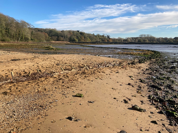
Overview of preparatory works, Loompit site

Pioneer growth west site