The geomorphology of the River Taf Estuary as a context for the evolution of the community of Laugharne
Simon Read, Thomas van Veelen
- identify and define the key health and wellbeing values associated with salt marshes including how these have changed over time.
- identify realistic future intervention options for salt marshes, and using the guided outputs of artistic, natural and social science research (including national scale maps), provide evidence-based advice, to a broad range of stakeholders, regarding the management and utilisation of salt marshes to minimise impacts of future coastal flooding events and maximise health and wellbeing
- understand how salt marsh ecosystem components and processes provide health and wellbeing values and to model how different interventions and wider global environmental change, will alter them and, in turn, their value.
- develop and apply novel social science approaches to improve understanding of the health and wellbeing values associated with changes in salt marsh habitats.
Introduction
Any study of the symbiotic relationship between a community and its landscape must be based on an understanding of how each affects the evolution of the other. When research is devoted to a particularly chimerical feature of that landscape such as saltmarsh, it must also require insight into its history and the degree to which it has been a consistently active ingredient in local cultural memory. Landscapes impinge, enable or determine livelihoods to varying degrees: sometimes they dominate, sometimes they are overcome and sometimes they are just accommodated and ignored.
Over the last century, since continuity between the local and global has become increasingly commonplace via information systems and popular media, small local communities need no longer be imprisoned by their own landscape. Due to the development of road and rail communications, coastal communities are increasingly well connected and reliance upon a seaward location for their livelihood has become as much a matter of choice as necessity. Together these ensure that living in a small community is no longer an obligation, an effect of which is a higher level of social mobility. This can be a cause of rupture in the continuity of memory for how communities live with their landscapes, but can promote the development of more generic expectations of the benefits they provide as leisure amenity.
Through this study, I will refer to the writing of Dylan Thomas as a champion for the eccentricity of small isolated communities. In his 1934 BBC radio script “Quite Early One Morning” he developed his idea, “The Town was Mad”, for a town as an asylum, isolated from influences of the outside world. This became the basis for “Under Milk Wood” for which Daniel Jones, in his preface of 1954 comments:
Thomas thought he had found the theme he wanted in the contrast between the mythical town and the surrounding world, the conflict between the eccentrics, strong in their individuality and freedom and the sane ones who sacrifice everything to some notion of conformity
The key focus of this essay is the role that saltmarsh of the Lower Taf Estuary has played in the lives of the community and the extent that it is valued to the present day according to cultural narratives evinced from a range of sources including surviving literary and visual evidence. Although there is an inevitable but not unwelcome risk of straying into other disciplinary territories, an open-ended deductive approach working inwards from a broad overview can lead to surprising congruencies with other methodological approaches and add a dimension to a study that may otherwise not be so readily accessible. For this particular study, we have used available evidence of the topological and cultural conditions that have influenced a societal sense of attachment to or dissociation from the immediate landscape and in particular how this may be applied to such an ephemeral feature as saltmarsh.
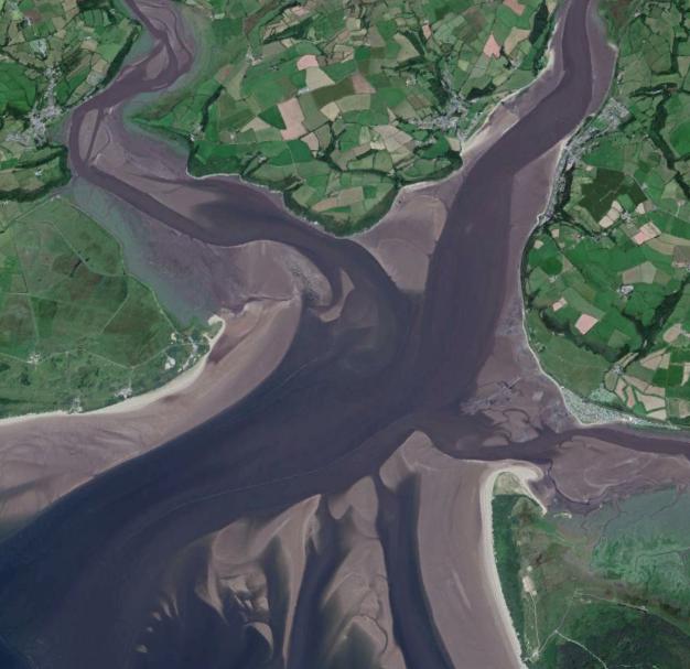
Given the complexity of any dynamic coastal system, speculation upon the society that lives with it must start with a grasp of the evolution of the system itself. What follows is an exploration of the relationship between the community of Laugharne, a small settlement just inside the Taf estuary on the West Coast of Wales and the forcing effect that long-term landscape change has had upon it.
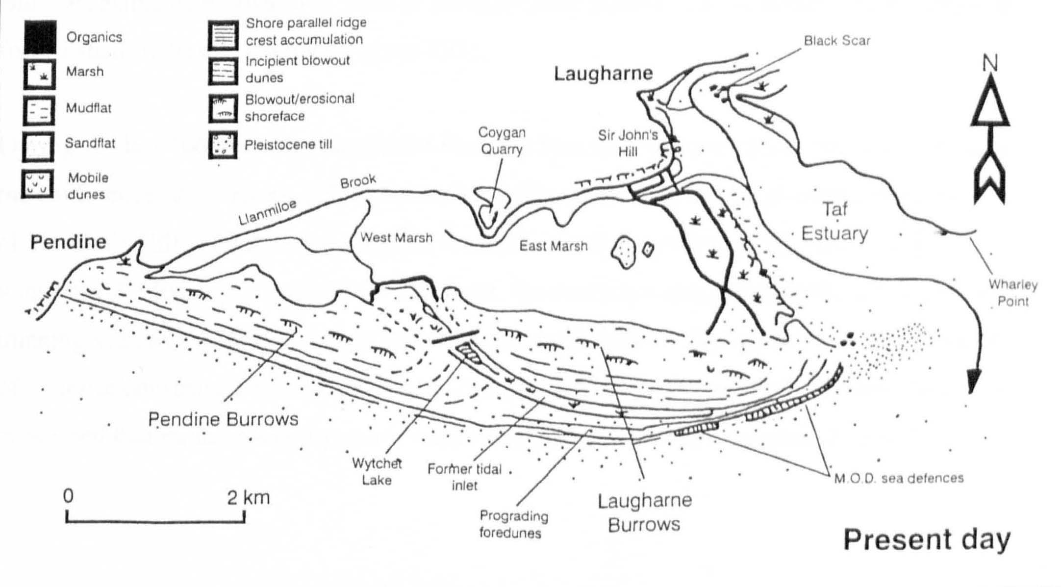
Due to its immediate coastal and estuarine morphology and by dint of its tidal prism, Laugharne became a significant settlement for a certain period of time. But this was not to be forever and, as the Pendine/Laugharne Dune Barrier at the entrance of the estuary pushed ever eastwards, it progressively silted up and the capability to support navigation gradually diminished. Where in previous centuries Laugharne enjoyed strategic prominence as a port with a grand castle to protect it, by 1575 under the stewardship of Sir John Perrot, its role as a stronghold against hostile approach from the sea had become redundant and its status little more than symbolic. In 1664, it finally met its nemesis in the form of Cromwell’s troops, when, this time from a landward direction, it was outflanked, bombarded and breached.

Since my study of Laugharne started as a speculative and eclectic information- gathering exercise, I became increasingly aware that, to ensure credibility, this must to be underpinned by a clear understanding of the geophysical context. The Coastal Scientist, and co-author of this text, Thomas van Veelen kindly introduced me to the work of Stuart Walley on coastal dune barriers and Abdul Kadir bin Ishak upon the sedimentation of the Taf Estuary. Taken in combination, these texts address the dynamic changes the estuary has historically undergone, which the community took advantage of and promoted through reclamation works, until such a time that the continuing process of sedimentation made navigational access to the estuary unreliable and the harbour at Laugharne unviable.
With reference to these two key texts: “The Holocene evolution of a coastal barrier complex, Pendine Sands: Stuart Walley 1996” and “Suspended Sediment Dynamics and Flux in the Macrotidal Taf Estuary, South Wales: Abdul Kadir bin Ishak, 1997”, I have endeavoured to contextualise my enquiry into the morphological transformation of the Taf Estuary driven by the incremental growth and extension of the Pendine/Laugharne Dune Barrier.
Between medieval times and the mid 19th century the Pendine/Laugharne Dune Barrier provided suitable conditions for the development of a viable community, but due to increased siltation and the constraints this has imposed upon easy access to the estuary and the sea beyond, those same sheltered conditions that promoted agriculture, fishery and a thriving township at Laugharne, have eventually led to its separation from an estuary based economy.
In the face of this apparent reversal in fortune, Laugharne remains remarkably resilient and has achieved a renaissance, partly due to the cohesiveness of its community and not the least exemplified by the legacy of Dylan Thomas, whose work, incidentally, is a paean to all that is indefinable in human society. There is a point in its evolution when, any community may have acquired sufficient traction to respond to adversity through adaptation beyond the original conditions of its settlement. As in Dylan Thomas’s Llaregyb there is a strong tendency for a community to develop idiosyncratically in spite of its landscape as much as because of it. Small towns evolve their own genius loci through the individuality of their inhabitants; bloodlines, personal relationship, friendship, neighbourliness and even antipathy forge the peculiar identity of a place that may as much be influenced by its own DNA as by external influences such as loss of livelihood or the injection of a new gentility.
“This is Llaregyb Hill, old as the hills, high, cool, and green, and from this small circle of stones, made not by druids but by Mrs Beynon’s Billy, you can see all the town below you sleeping in the first of the dawn. Less than five hundred souls inhabit the three quaint streets and the few narrow by-lanes and scattered farmsteads that constitutes this small, decaying watering place which may, indeed be called a ‘backwater of life’ without disrespect to its natives who possess, to this day, a salty individuality of their own.”
The Holocene evolution of a coastal barrier complex, Pendine Sands: Stuart Walley 1996
This study by Stuart Walley is a comprehensive data gathering exercise for which the point of departure is the underlying geology of the area. The research provides substance for insight into the evolution of the Pendine Barrier and the impact this has had upon morphological change in the Taf Estuary.
Although the conclusions reached by Walley are vital to this study, how he got there and the multidisciplinary processes used to evince data, would be too digressive for our purposes. Indeed, it would not be doing his research justice to attempt a summary, since it deploys methodologies as diverse as the use of seismic refraction to determine the nature of the bedrock, the extraction of core samples from which mineral deposits might be traced, radiocarbon dating carried out upon foramifera samples and the analysis of pollen samples. All of this and much more besides renders a comprehensive picture of the evolution of the Pendine and Laugharne Barrier system and the influence this has had upon the sedimentation of the Taf Estuary and the development of its saltmarsh sites. What follows, with reference to Walley’s text and support from Thomas van Veelen is my understanding of the key stages of the development of the barrier complex, the history of human intervention and the effect this has had upon its continuing evolution.
The formation of the barrier relies upon two key geological features:
- A ridge of glacial till deposited during the Pleistocene period anchors the western portion of the barrier.
- A fossil cliffline runs from Gilman Point barrier approximately northeast to the hard outcrop of Coygan and Sir John’s Hill; this feature also marks the southernmost limit of the glacial ice sheet and shows no evidence of wave erosion. The reason for this is the underlying ridge, which fixed the onshore surf line. However the cliffs of Sir Johns Hill remained exposed to weather and wave action until the time that the barrier extended sufficiently eastward to create a shadow area.
The early development of the barrier:
- Although the development of the barrier was inconsistent it underwent two key periods of stability between 6,200 – 5,700 and 4,500 -3,500 years BP. These were times of progradation and spit development from sediment deposits in Carmarthen Bay.
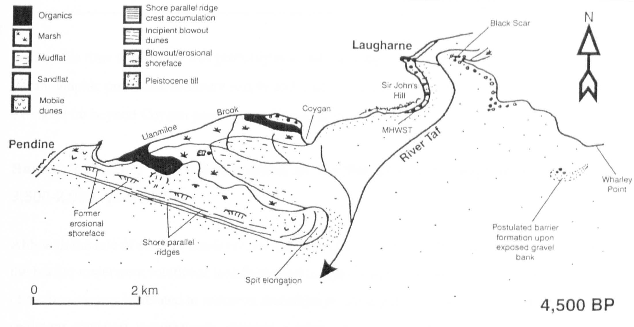
- Those periods of instability and breakdown were most likely caused by periods of storm, but the ridge beneath the western portion of the barrier prevented total breakdown of the system.
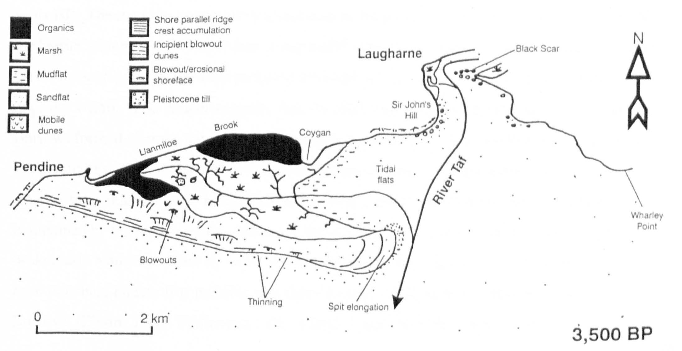
The subsequent evolution of Pendine and Laugharne Burrows:
- As the Pendine Barrier developed eastwards it forced the meltwater channel Wytchett Brook further east to drain into the tidal flats sheltered by the distal end of the barrier.
- In the period around 2,000 BP a period of instability caused the barrier to breach and a tidal inlet to form connecting with Wytchett Brook.
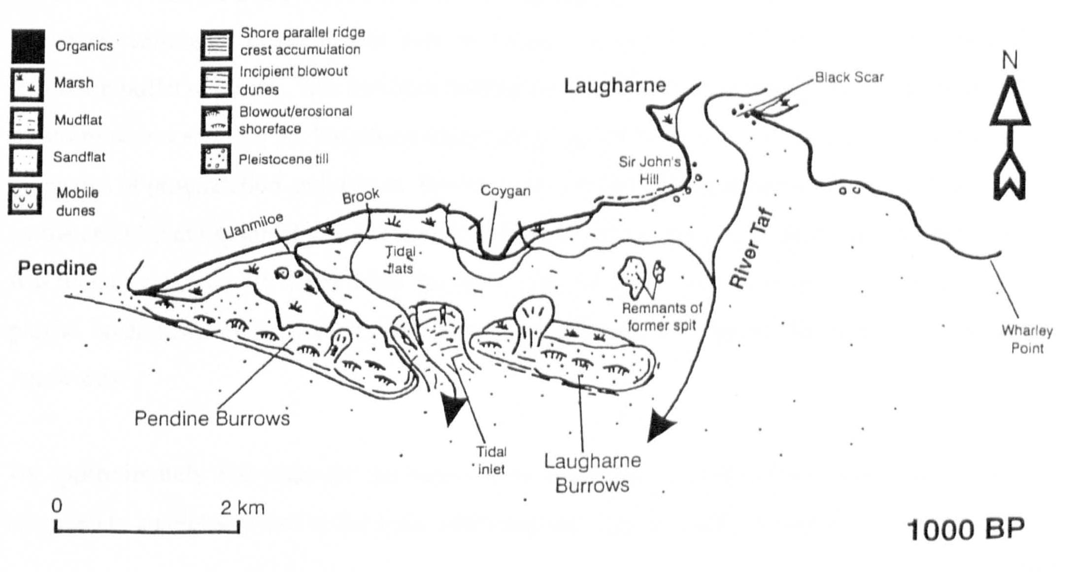
- Wytchett Inlet remained active as a tidal exchange until the 17th century. The section of the barrier to the east of the inlet, nominally Laugharne Burrows, continued to prograde eastwards with periodic breaching and breakdown.
Although there is abundant evidence of prehistoric human activity on the lower Taf, which includes the human settlement at Coygan uncovered and destroyed by the quarrying activity, a substantial shellfishery at Laugharne Burrows dating from the stone age, and a history of the use of the back barrier marshes for pasture, it was not until the medieval period and after, that communities actively took advantage of the shelter afforded by the dune barrier. At this time Laugharne was also growing in importance as a sheltered trading port, equally connected to the sea as to its hinterland, and located strategically to command its seaward approaches (Tyler 1925).
However, it was not until the 17th century that major human intervention to manage the barrier and the back-barrier marshes accelerated the process of change in the reciprocal dynamics of the geomorphology of the site and the rate of sedimentation within the River Taf Estuary (James 1991).
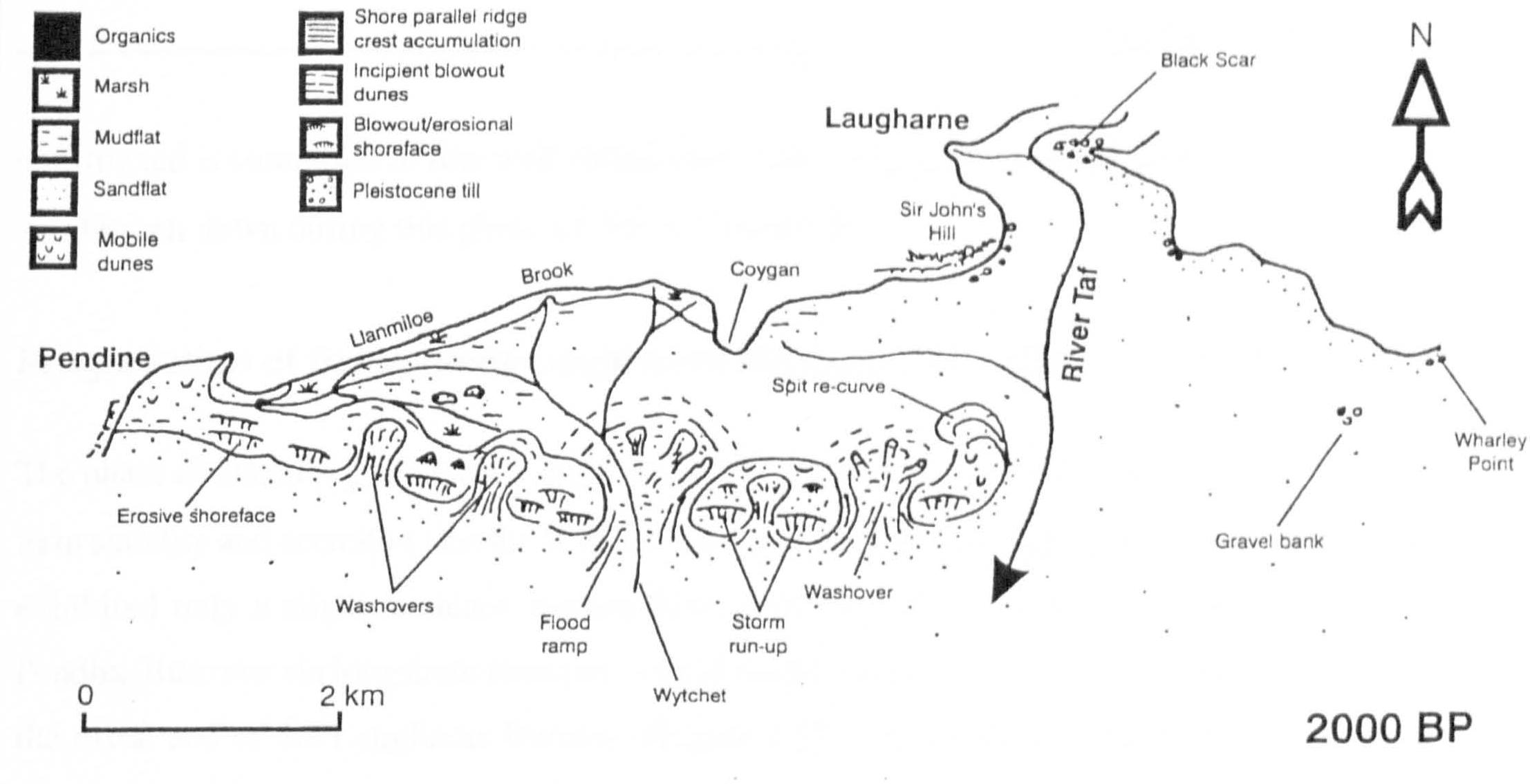
The barrier after human intervention:
- The continuing progradation of Pendine and Laugharne Burrows eastward created an extensive fresh and salt water marshland in the back barrier area that was already being used as pasture at the higher end of the West Marsh. Evidently, by the 17th century, when there was sufficient interest in its potential for financial return as a grazing marsh, it was considered stable enough to be a candidate for reclamation.
- In 1660 Sir Sackville Crowe had a seawall built across Wytchett Inlet and the back barrier, and an embankment connecting the foot of Sir John’s Hill and the distal end of Laugharne Burrows. Together these transformed the brackish back barrier marsh into a fresh water grazing marsh. In the first instance the accumulation of fresh water in the back barrier marsh was drained into Witchett Brook and via a sluice out over Pendine Sands.
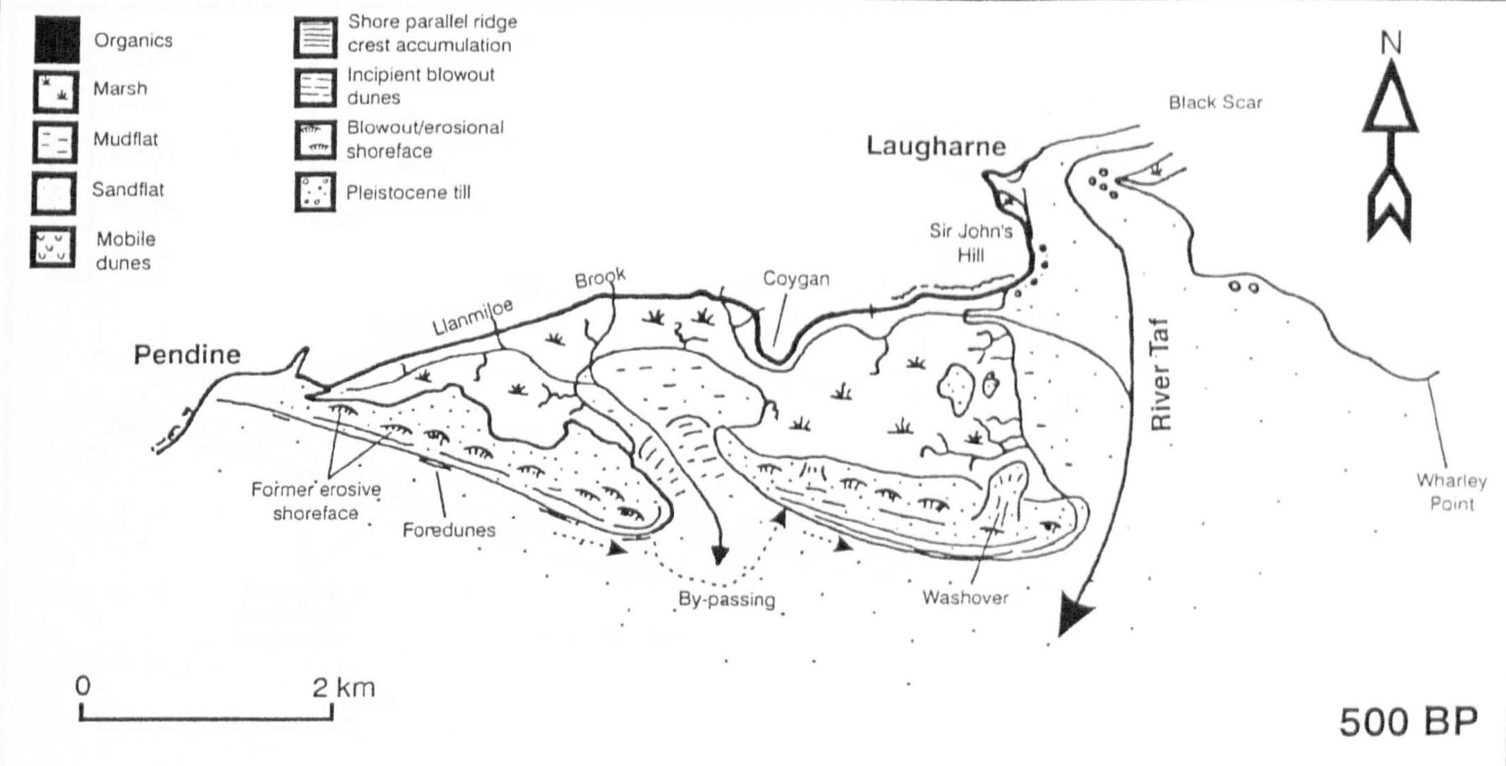
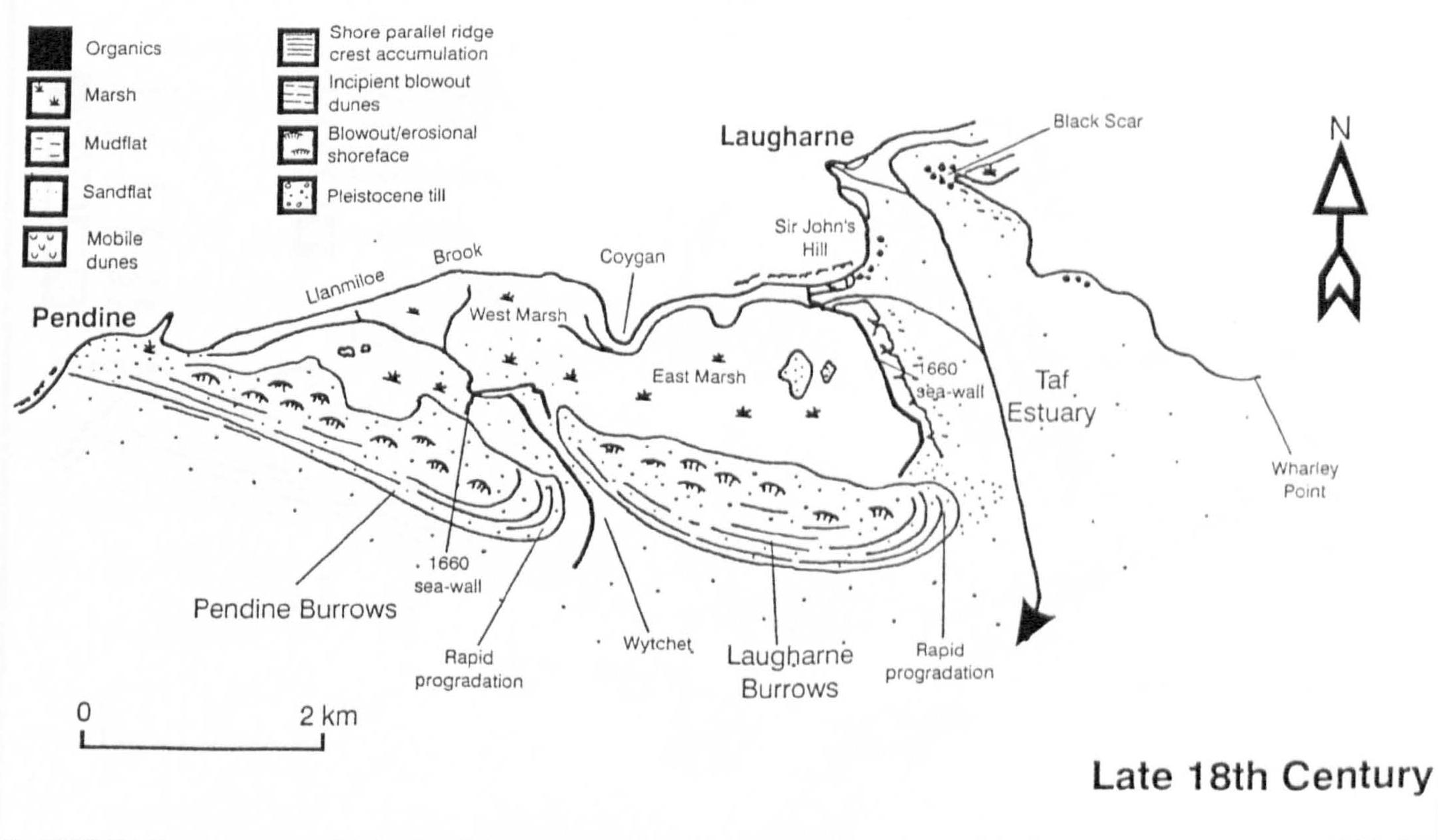
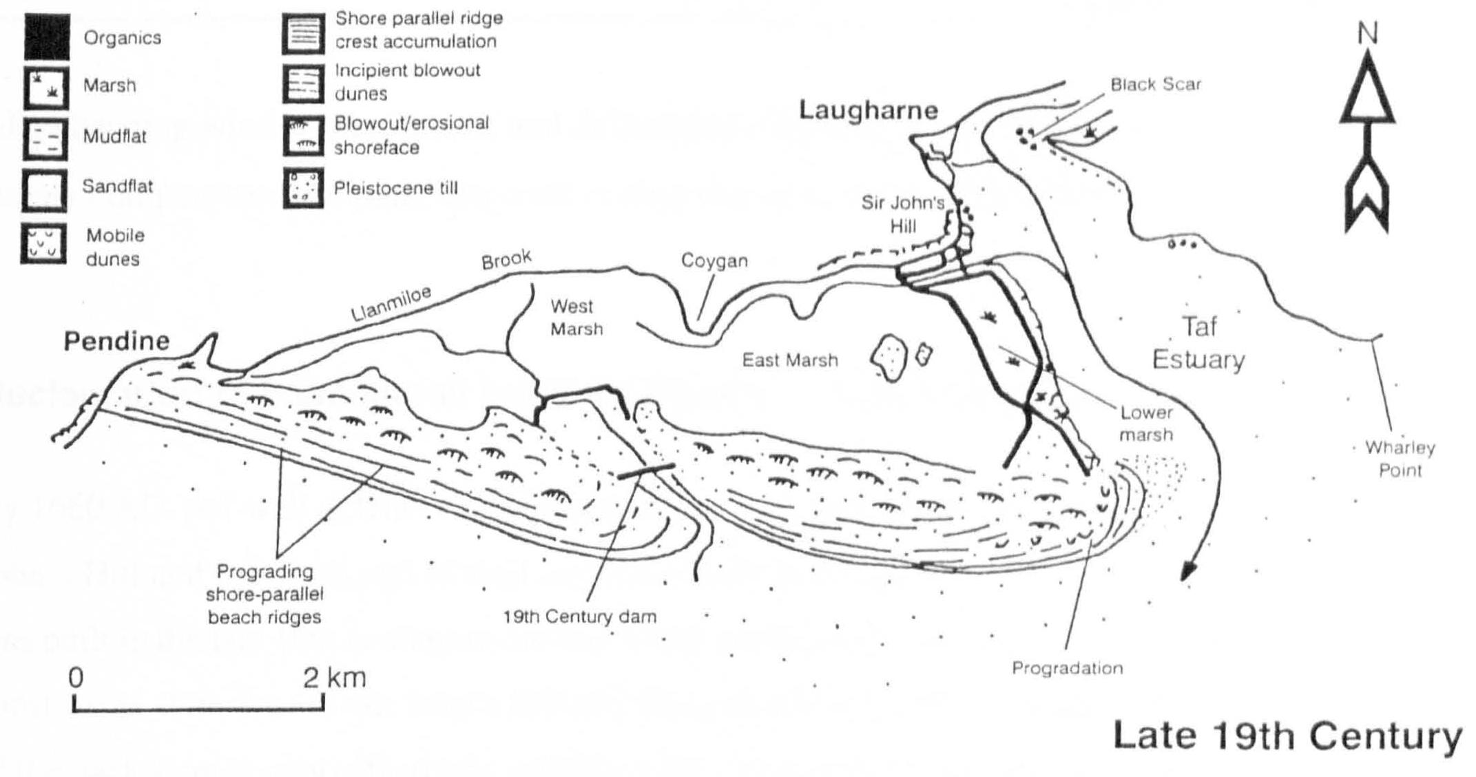
- Between 1800-1810 George Watkins of Broadway caused a further embankment to be put in place to enclose the Lower Marsh and link it to Ginst Point at its location at that time. As a result of this and since then the barrier has continued to prograde further east and within the past century a further area of saltmarsh has been generated within its shelter.
- By 1840, two dams were constructed: one across Railsgate Pill at the foot of Sir John’s Hill and the other across Wytchett Inlet. These acted to further consolidate the reclaimed marshland and at Wytchett Inlet, enabled Pendine Burrows to join up with Laugharne Burrows, effectively impounding the relic of Wytchett Brook as a freshwater lake.
The contemporary configuration:
By the second half of the 20th century Pendine and Laugharne Burrows had become a single feature, which continues to prograde. There was concern in the 1970’s over the potential for the system at the distal end of the barrier to break down and breach. As a consequence the MOD installed sea defences, which had the effect of promoting further sedimentation and progradation. Apart from the need to protect infrastructure located within the dunes, it is unlikely that this measure was necessary to safeguard the integrity of the barrier. There is strong evidence that the reclaimed and still accreting marshes and the barrier spit behave according to their reciprocal advantage. The marshes have acted to stabilise the spit by greatly reducing hydrodynamic energy behind it.
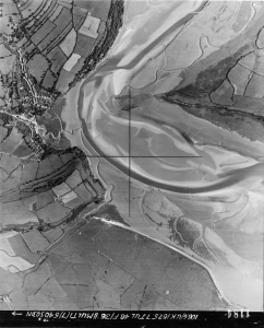
There is at present little sign of the flow of sediment into the estuary slowing down, as a consequence the sandflats at the entrance continue to delay tidal ingress, holding it back on the flood and retaining it on the ebb, imposing an identifiably asymmetric tidal cycle.
The research conducted by Walley provides insight into the physical processes against which the growth of the saltmarsh complexes within the Taf Estuary provided suitable conditions for a burgeoning community, but which, as they continued to accrete rendered the harbour inaccessible to all but small draft vessels, smothered those cockle beds immediately accessible on the Laugharne foreshore and forced the decision to construct a wharf for trading vessels closer to the tideway just beyond Dylan Thomas’s Boathouse.
This research has enabled me to understand the hydrodynamic conditions against which the strategic importance of Laugharne developed, flourished and gradually declined, but for insight into the geomorphology of the saltmarshes themselves I have turned to another study:
Suspended Sediment Dynamics and Flux in the Macrotidal Taf Estuary, South Wales. Abdul Kadir bin Ishak 1997
As with the research by Walley, I hesitate to go so deep as to risk becoming lost. What follows is my digest of the essence of Ishak’s thesis as applicable to our particular enquiry into the benefit the community receives from the saltmarshes in the Taf Estuary.
The hydrodynamics of the River Taf:
- The River Taf is a macrotidal estuary, with a mean spring tidal range of 7.5m.
- Due the accumulation of sediment at the entrance of the estuary, the tide must rise 2metres before it can enter it. This means that when it does it enters at a high velocity and rises rapidly. Correspondingly, it is held back upon the ebb and therefore has a slower fall. This is the principle of an asymmetric tide where flood rise is shorter than the ebb (previously referenced in the discussion of the study by Stuart Walley).
- Peaks in flow correspond to the point at which the tide overflows the sand flats at the entrance and when it overflows the saltings.
Ishak makes a case for the “Coriolis Effect” for tidal incursion and fresh water flow, which is that the rising tide will be drawn to the left side of the estuary whilst the downflow of fresh water will be drawn to the right. This will induce an anti clockwise horizontal mixing of salt and fresh water. Arguably, local features such as the dune barrier, equally well influence the circulation of tidal flow. - An effect of an asymmetric tide is that more sediment is brought into the estuary on the flood than is taken out on the ebb.
Sedimentation:
- Although this is not consistent, annual sedimentation rates can be as much as 6.2cm/yr. However, this can be very dynamic and therefore should not be considered indicative. A more realistic average for the accretion of fine particles within the estuary is 1.8cm/yr.
- Saltmarsh accretion: two historic horizon indicators for saltmarsh accretion are the fallout from atmospheric nuclear tests in the 1950’s-1960’s which put radio nuclide into the atmosphere, and which became measurable within saltmarsh sediments from 1963-1964. The other event is the fallout from Chernobyl in 1983, although the effects of this event are much more localized and therefore of varying intensity.
- The average accretion rate for the saltmarshes on the Taf, measured at station points on Delacorse Marsh (Boathouse Marsh) Malt House Marsh and Black Scar Marsh is 1.01cm/yr. It is regrettable but understandable that Laugharne Town Marsh was not measured since it is here that the most tangible threat of overtopping would be felt, but also where there is the greatest amount of human intervention and therefore the most unreliable source for data.
- According to Ishak, the estimate for sea level rise is 1.5-2.00mm/year, which is well within the the limits of what current levels of accretion will cope with.
Taken together, these studies by Walley and Ishak encapsulate both the coastal dynamics of Carmarthen Bay and the sedimentary system Taf Estuary and how they link directly to a cycle of human response, from exploiting change to eventually adapting to it.
Thomas van Veelen, technical commentary:
With particular emphasis upon Laugharne, the question of landscape change in the Taf Estuary is fundamental to this research. Given the rapid development of new salt marsh at Laugharne South1 through the 20th century, it is crucial to this historical analysis to identify the period over which the Laugharne Shore changed from beach to salt marsh, whether for example the conditions during the catastrophic flood event of 1607 were at all comparable to today, how flood risk has changed over time and to what degree changes in the fortunes of the town mirror the evolution of the estuary?
A salt marsh needs (at least) three conditions to establish: sediment supply, seed supply and non-erosive calm hydrodynamic conditions when seeds settle (Poppema et al., 2019). When these conditions are satisfied, a marsh may develop as a mutual relationship between flow and vegetation. Salt-resistant plants opportunistically colonise in small outcrops that focus flow, which in turn promotes scour as a precondition for creek expansion (Temmerman et al 2005). This creates slack conditions in areas peripheral to the creek network, which promote further propagation and create a dynamic for vegetation and the creek network to respond reciprocally to each other
Sediment and seed supply have always been plentiful. We know from bin Ishak that the Taf is essentially a flood dominant estuary importing sediment on the flood tide and carrying seed stock down on the ebb from salt marsh species upstream (bin Ishak 1997). Concerning a calm hydrodynamic environment: early photographic evidence shows a sandy gravelly, shelly shore, which normally would be associated with relatively high wave and tidal energy conditions, however the configuration of the current marsh suggests calm conditions typically consistent with the slack water zone of an embayment. Given the context of an easterly propagating barrier spit, the further it extends, the more shelter it provides to the lower estuary as a whole. This in turn provides suitable conditions for the transformation of the foreshore from gravelly beach to mudflat to pioneer marsh and eventually to generate the evolved salt marsh as we see it now.
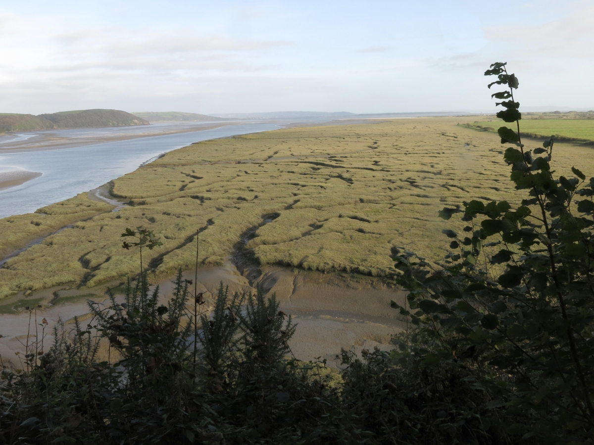
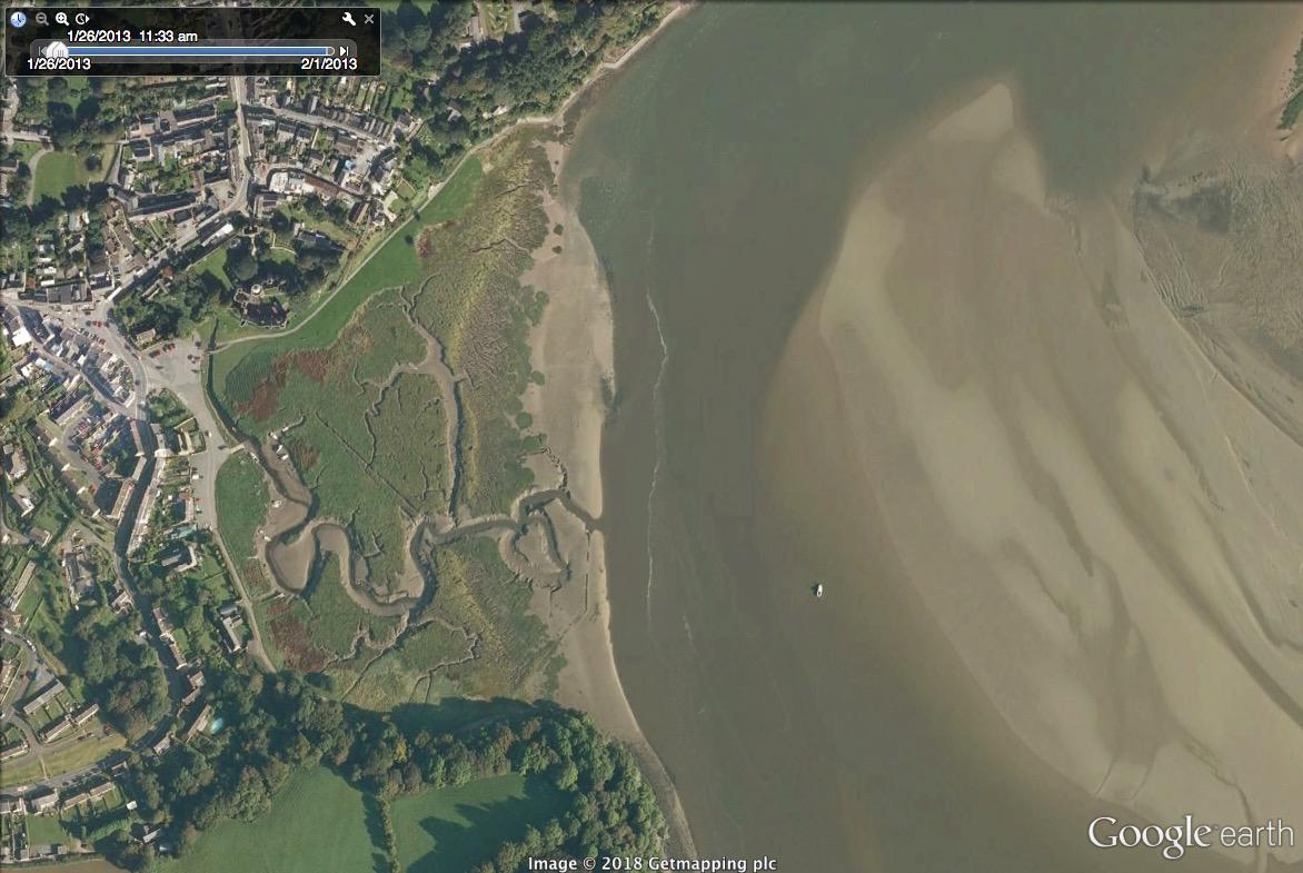
As saltmarsh matures, so it reflects the fluvial characteristics of any other floodplain watercourse. Recently, at a point where the bends in the channel system of the Town Marsh have become increasingly tortuous, a pronounced meander has broken through. This might be due to a strong flow event that could not be contained, such as when the river Corran is running in spate. Whatever the cause, sediment transport patterns are affected, the bed gradient locally increased, leading to higher velocities in the new channel and increased scour, whilst the relic of the old channel, may slowly fill. Sediment transported out on the ebb will stabilise pioneer marsh downstream, potentially promoting further expansion of the system. However, since this is the only major event that has happened in the marsh since 1946, it is safe to assume that it is the result of normal fluvial behaviour and consistent with a dynamic system.
Having discussed the past and current changes within the estuary with reference to Walley and bin Ishak, it is worth while reflecting upon those implications, which are most applicable to coastal planning in the future. From their respective studies, the key elements for estuarine evolution are the spit extension and the stability of the salt marshes.
Although the barrier spit continues to propagate eastwards and there is, at present, little evidence of this slowing down, it may not continue: as the spit extends eastwards, the mouth of the Taf narrows causing an increase in tidal velocities, which would erode the cross section of the mouth, thus hampering further propagation to the extent that there may be a point when an equilibrium is reached (Roos et al., 2013). Yet as long as the spit extends northward, it provides increasing shelter against rough conditions within Carmarthen Bay (Pye & Blott, 2009, from SMP2, Appendix C), which benefit marsh accretion. The continuous propagation is further evidenced by its extension beyond the stabilisation works by MOD as referenced by Walley.
Where sea level rise is widely acknowledged to be the dominant threat for UK salt marshes – all marshes in the UK have at least 80% likelihood of retreat by 2100 due to sea level rise –, scour would become a specific threat for the marshes in the Taf estuary. At present the rate of accretion of the marsh is more than keeping pace with current estimates of sea level rise; However, the main estuarine channel is very mobile (Bristow & Pile, 2003) and currently scours marshes both at Laugharne South and along the frontage of the Town Marsh, as was shown in a field campaign by Dr. Tom Fairchild in August 2017. However, in the absence of sufficient supporting evidence and a specific study of channel movement, there is not enough information against which the future correlation between the tidal channel and the loss of saltmarsh due to scour may be predicted.
Apart from their obvious ecological value plus the contribution to landscape experience they provide for the local community, stable salt marshes perform a vital in coastal protection. Salt marsh vegetation is increasingly appreciated for its ability to attenuate wave energy (Temmerman, 2013). Furthermore, the canopy contributes to accretion by capturing sediment, (Bouma et al., 2014), which is subsequently stabilized within the root structure (Fagherazzi et al., 2012; Möller et al, 2014). This generates a shallow habitat, which provides sufficient friction to dampen and decelerate tidal and wave energy.
We have traced a gradual transition from an open coast to a sheltered estuary filled with marshland. At present, the spit provides shelter against the most extreme waves whilst the marshes provide a buffer zone between extreme wave action within the estuary and the settlement. Arguably, a storm similar to that of 1607 is less likely to threaten the village today. However, a combination of climate change, with the effect of sea level rise and increased frequency and intensity of storm events (IPCC, 2018), taken in the context of contemporary flood risk management standards, is likely to press our existing saltmarsh complexes beyond their ability to cope. For Laugharne, the most recent Shoreline Management Plan (SMP2, 2012) recommended the construction of a flood wall in front of the village. However, this proposal was rejected by the villagers, who, for the time being, prefer to mitigate risk through the use of demountable flood boards by individual householders.
The Shoreline Management Plan and Managed Realignment
It is salutary that, for aesthetic reasons, the community of Laugharne rejected the proposal to place a flood wall along the Strand across the back of the marsh, preferring instead to make its own local arrangements. The unwillingness to accept solutions dropped from above and to manage risk on the ground, as a matter of continuing adaptation is becoming a positive sign of community resilience, particularly when there is no immediate need for major infrastructure intervention.
Although the SMP2 recommendation for the medium term for the Malt House Marsh between Laugharne and Ginst Point is to set back the defences through managed realignment and create compensatory habitat against loss in other coastal locations, this would be at the expense of the current freshwater marsh habitat, and would disadvantage some of the existing commercial interests on the marshes. Given that the reclamation of the marshes between the 17th and 19th centuries took advantage of an area that was already accreting and therefore lent itself to “improvement”, and that the region continues to absorb more sediment than is either lost to tidal action or is necessary to balance sea level rise, it is debatable whether a managed realignment exercise would do more than what is effectively already happening through estuary processes, other than consolidate the levels already there. However, given future need for flood protection this could still become a consideration as a flood holding area.
Thomas van Veelen, technical commentary:
The question of the effectiveness of managed realignment due to the progressive tendency of Laugharne Burrows to migrate eastwards and the continuing stability of those marshes already reclaimed, is a fair and interesting point. But first we should re-explore the goals of managed realignment from a flood protection perspective. These boil down to two key reasons, which are:
- The creation of a buffer zone by which the distance between land and sea is increased, thereby mitigating threat by the water body to the land (see technical commentary on Walley and bin Ishak). However, since the back barrier marshes are fundamentally farmland, this is strictly not applicable since they are inconsistent with a cost-benefit analysis.
- Where flood water storage is put in place to alleviate flood levels elsewhere, the additional available area increases the volume of water required to fill the estuary, potentially reducing the water levels upstream. However, when the water level rises faster outside than inside the estuary, velocities and discharge into the estuary may increase. This side effect may reduce the efficacy of the intervention. This is in contrast to fluvial flooding, where the supply of water is restricted to whatever amount happens to be within the system.
In a study of the macro-tidal Parrett estuary in Somerset, Prof. Nigel Pontee (2015) showed that managed realignment close to the mouth drew additional water into the estuary. A proportion of this was found to bypass the breach, raising water levels upstream. This dynamic is more pronounced for larger realignment sites, which significantly alter the tidal prism, and sites that flood quickly. Furthermore, a fully natural system would respond by widening the entrance thereby decreasing the effective extra storage. For the Taf Estuary, it would be feasible to mitigate this by stabilizing the spit, as carried out in the 1970’s by the MOD, but such an intervention would be counterproductive and not in the spirit of managed realignment.
The long-term benefits of managed realignment may be more subtle and linked to the stability of the marsh. A stable realigned Laugharne South Marsh would be more resistant to changes in the channel pattern, would reduce flow velocity and consequently benefit accretion of other marshes, particularly Laugharne Town Marsh, which in turn may further reduce storm impact.
Two further reasons why saltmarsh stability would benefit from managed realignment are:
- According to evidence derived from aerial photographs and from google earth, it appears that the 19th century reclamations advanced the line beyond the saltwater boundary of the marsh. It can be seen that creek networks have either become truncated by the floodwall or bend parallel to it. Since the elevations of the marshland ~3.60 m ODN are well below high spring tides ~5.20 m (Pye, from SMP2, Appendix C), under current conditions, the land behind the floodwall would be intertidal. In times, such as now, of foreshore retreat, the chances of survival increase when it can migrate backwards to retain a healthy sediment and seed supply (Fagherazzi et al. 2012). Effectively, the existing floodwall prevents this from happening.
- Since the closure of the Wytchett Brook, Railsgate Pill next to St. John’s Hill has become the main drain. After managed realignment, this would discharge directly onto the marsh, which would benefit from the increased sediment supply.
Managed realignment won’t stop scour and we still find it hard to quantify these processes, however the outcome is more likely to be positive than negative. According to Iris Moeller’s paper on the Freiston Marsh, the benefits to marsh stability after breaching exceeded expectations. It might be worth consulting other locations such as Alkborough Flats on the Humber or Steart Point on the Severn Estuary, which are also examples of ambitious managed realignment projects.
The parallel evolution of the community of Laugharn
Gaining insight into a community through the lens of its landscape is fraught with pitfalls. To the outsider, it may seem counter-intuitive that the presence of a ballistic weapons research station at Pendine Burrows should be considered benign; yet locally it has become accepted as both an accustomed neighbour and a valued employer that supplements the economy of the district. Under other circumstances the prospect of unimpeded access to a continuous estuary landscape could be a driver for a sense of community ownership and responsibility for its wellbeing. But the lesson of living with locations as found can be much more persuasive than speculation upon what they might otherwise be. As it is for any other community, there is so much unforeseeable circumstance and unpredictable consequence that cause the story of Laugharne to slip in and out of focus in parallel to, rather than driven by, the conditioning effect of geomorphological change.
Rhetorical questions over the transformation of a community in the context of a changing landscape and how they reciprocally influence each other can never be resolved. A point of view set within a given landscape provides the “mise-en-scene” against which human stories are told. Being as applicable to any other small coastal town as to the community of Laugharne, the popularity of “Under Milk Wood” is in its universality, which testifies to the capability of a community to develop its own dynamic through the give and take of interpersonal behaviour, from which a collective and idiosyncratic identity evolves. This may be as loosely or closely connected to place just as are the characters in Steinbeck’s “Cannery Row” to their rundown waterfront neighbourhood in Monterey California.
Llaregyb: a limpid early morning. The fishermen adopt a characteristic indolence at the prospect going out to sea:
“But with blue lazy eyes the fishermen gaze at that milkmaid glistening water with no ruck or ripple as though it blew great guns and serpents and typhooned the town.
Too rough for fishing today.
And they thank God, and gob at a gull for good luck, and moss-slow and silent make their way uphill from the still still sea, towards the Sailors Arms.”
Men and women, wives, daughters and hopeful youths, melancholics and dreamers share for a night and a day and a night their fantasies and regrets, frustrations and hopes all organically bound as a collective unit within the cleft in the hills called Llaregyb, which could easily be Laugharne.
It is spring, moonless night in the small town, starless and bible-black, the cobblestreets silent and hunched, courters-and-rabbits wood limping down to the sloeblack, slow black, crow black, fishingboat-bobbing sea.
Hush, the babies are sleeping, the farmers, the fishers, the tradesmen and pensioners, cobbler, schoolteacher, postman and publican, the undertaker and the fancy woman, drunkard, dressmaker, preacher, policeman, the webfoot cocklewomen and the tidy wives.
This is anywhere and somewhere, it is a dislocated fiction born of a specific place which itself must be vivid enough to foster the myth. From this study it is clear that the conditions that encouraged human settlement were not to be forever and that the busy and strategic medieval port would, by the 20th century have fallen into genteel somnolence to re-awaken in the 1940’s as host and inspiration to the wider cultural world represented by Dylan Thomas and his friend Richard Hughes.
The lesson I have learned from Dylan Thomas is that although experience must be located in time, place and culture, it can never be so readily determined. A particular landscape may afford a context, but life carries on within it, answering to it but never prescribed by it.
The castle and the marsh:
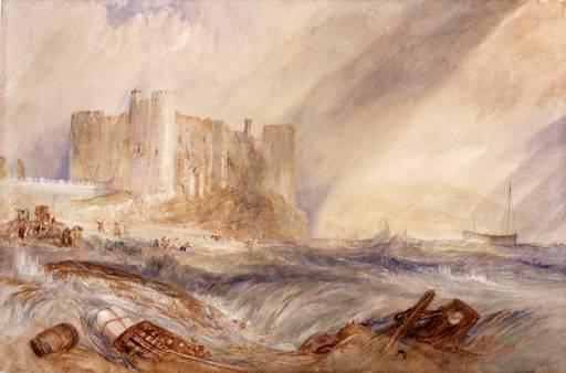
Although in Turners time a high spring tide could still wash the footings of the castle, it is debatable whether this is a generic work or if it deliberately evokes the subliminal memory of other calamitous storm events, such as the great flood of 1607 that affected the Severn Estuary and the Welsh Coast as far west as the Three Rivers Estuary or even the Great Storm of 1703, which was of such severity as to cause the loss by 20% of the Naval Force at that time. Attractive though this might be as speculation, whether or not these events had an impact upon either the landscape or the psyche of the populace has proved unverifiable and my search within the archives of the corporation has so far not borne fruit. As a consequence all that remains is hearsay.
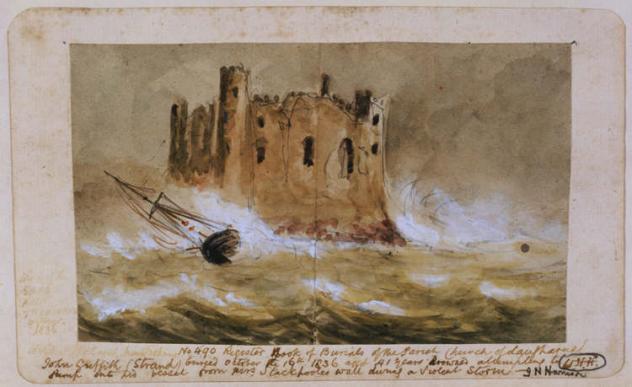
Harrison also wrote an epic poem “The Night on the Mast” in 1868, commemorating of the wreck of the schooner “Gem” of Hull on Laugharne Burrows in 1867.
Considering the question of veracity for both the Turner painting of Laugharne Castle and the record of the wreck of the Sarah Anne Trehearne, it is worth reminding ourselves that these come from a time before the development of photography and therefore express as much the embodied experience of a storm as its documented appearance. My assumption is that the sketch of the wreck is a surrogate for the event and the extreme weather conditions at that time rather a faithful record of it. For Turner, his famous painting “Snow Storm-Steamboat off a Harbour’s Mouth” of the 1840’s reflects the sensation of an elemental and immersive experience that also serves to evoke rather than record the event.
It is worthwhile noting that David Cox the landscape painter and much less flamboyant contemporary to Turner, concurred with him over the appearance of
the foreshore at Laugharne in the 19th century. I have located two images by Cox of gatherings on the beach, both of 1849: “Laugharne Castle at low tide, full moon rising” appears to represent a familiar activity such as cockle gathering, but the other has an urgency also driven by a storm event; a boat is being launched, perhaps to go to the aid of a ship in distress immediately offshore, whilst the bustle on the beach could be around a prone washed-up figure. As opposed to the scene described by Turner of wreckage being salvaged from the surf, this could reflect a more humanitarian response to emergency.
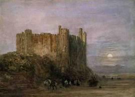
David Cox, Laugharne Castle Low Water 1849
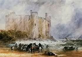
David Cox, Laugharne Castle 1849
Although, according to our research, the bay has been steadily silting up since before Laugharne Castle was established in 1116, the visual evidence that I have gathered dating from 1740 onwards indicates a gradual transition. Originally an open port that allowed vessels to enter on the tide, lay alongside and dry out at low water, it is now an established saltmarsh with a creek system and a serpentine drain channel formed by the River Corran. Whilst this limits access it affords a greater degree of shelter for shallow dreft vessels. By the late medieval age the Pendine Burrows were accreting enough to create suitably sheltered conditions to exploit the transformation of the back barrier marsh into productive agricultural land, which was just when Laugharne was gaining strategic importance as a sheltered port with equal access to both its hinterland and to the sea.
By the 17th century, as landowners seized the opportunity to undertake reclamation works, the increased sediment load in the estuary was beginning to impact upon the capacity of the harbour at Laugharne. This period could be considered a transition point in the fortunes of the town, when the still active port of the 1740 view by Samuel and Nathaniel Buck, would become subject to rapid accretion and the growth of pioneer saltmarsh as apparent in a watercolour painting in the National Collection of Wales by an unknown 19th century artist. By 1887 it had become sufficiently well-established to be identified as a feature in the current ordnance survey map.
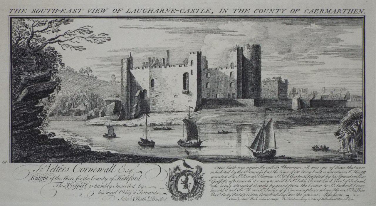
View of Laugharne Castle 1740. Nathaniel and Samuel Buck
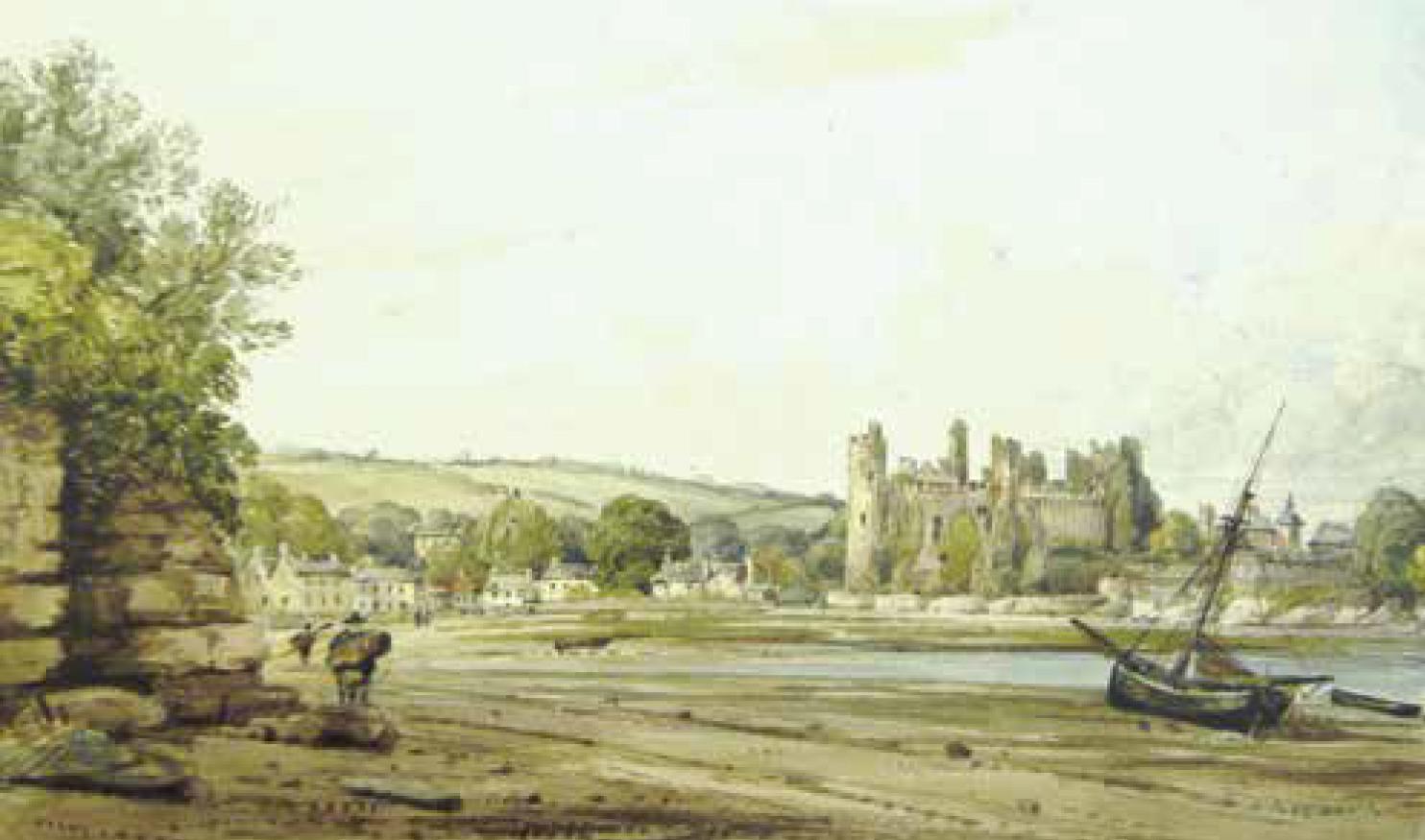
19th century view of Laugharne Castle, artist unknown. National Collection Wales
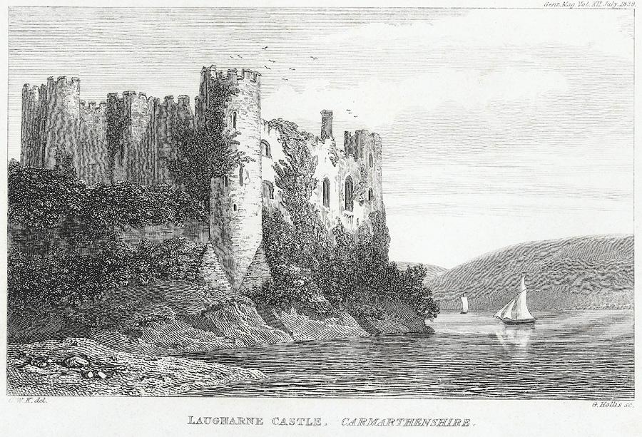
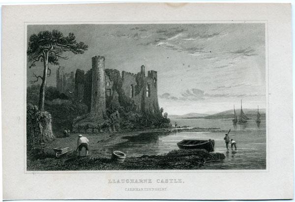
An engraving of Laugharne Castle at low water in 1835 by Henry Gastinau and one at high water by George Hollis of 1839 lend credibility to the paintings by Turner and Cox. Together they testify to a rough and stony foreshore regularly covered at high tide tide up to the footings of the castle. Further examination of the Gastineau image reveals a strand line from which a man is filling a wheelbarrow using a pointed spade: whether this is bait digging, collecting cockles or seaweed is not clear but it is evidently a familiar enough sight to also appear as a component in the low tide painting by David Cox.
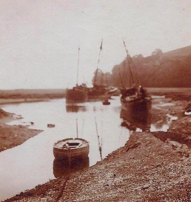
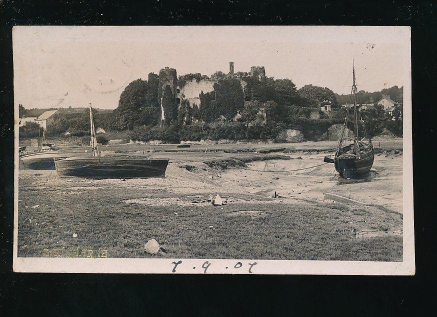
This is a matter-of-fact image, the vessels are unromantic the shore is a hard, shelly, shingly constituency, not yet sheathed in estuarine mud as it is today. In an image of 1907, another typical coastal trading smack lies moored up in the creek, by which time the saltmarsh sward has become established but the difference between the height of the marsh and the bed of the creek remains modest. . By the late 1920’s and 30’s the relics of this fleet may still be seen particularly in the photographs of Francis Frith, against a castle now festooned with ivy and a well established saltmarsh before it.
“this all could have been due to legislation e.g. urban waste water treatment directive requiring sewage treatment plants for all populations above a certain size. This was 1991 but there must have been some requirements before that”.
I have discussed the likelihood that the increase in the size of the settlement in the 19th and 20th centuries necessitated a more orthodox approach to wastewater management by discharging directly into the tideway, which may have created a more salubrious foreshore but may not have made much difference to the nutrient load received by the marsh. I queried whether there may be evidence of this in the type of saltmarsh vegetation and its distribution within the marsh and whether a nutrient rich environment may have served to promote its propagation or not. It would be a neat proposal that the settlement itself might inadvertently have aided the conditions for the generation of a healthy marsh, however upon reflection this is more than outweighed by the sheer amount of sediment in the system and a plentiful supply of estuarine muds to overlay it.
This is confirmed by Tom Fairchild, who is a marine ecologist, undertaking extensive analysis of the saltmarshes on the Taf for this project: he assures me that it is unlikely that input of nutrients into the system will have had any appreciable impact upon the composition of the marsh:
Although it may be doubtful that increased nutrient loading of the system may have impacted upon the composition of the saltmarsh, the awareness of the outfall in this location could well have a bearing upon the community perception of the saltmarsh as asset or liability. Whether it is an issue or not, the idea of an area that may be bathed in sewage twice a day just outside of your front door is perhaps enough of a disincentive to become engaged with it. Certainly the untutored and popular understanding of saltmarsh can be that it is both dirty and hazardous and therefore to be avoided.
Fisheries:
Fishing has been a major occupation in various guises at Laugharne since medieval times, but has been in decline over the past century. The practice near the entrance to the Gwendreath and Towy Rivers was to exploit stony ground close inshore to set up permanent fish weirs taking advantage of the high tidal range and easy accessibility from the shore. These grounds were known as “Scars” and include Salmon Scar, Pastoun Scar, St Ismael’s Scar and Ebb Scar.
In contrast to Black Scar on the Pentowyn shore directly opposite Laugharne town, the ground on the Laugharne side of the estuary is both too soft and too mobile to keep a fixed configuration for a fish weir and therefore did not lend
itself to permanent structures. However quite similar passive strategies to fish weirs were adopted through deploying nets manually over a single tide. This gave rise to the use of a range of techniques adapted to particular conditions, locations and species: these ranged from Back Nets, long low nets staked along the shore to trap fish left behind by the ebbing tide, Stream Nets, set directly in the tidal stream, Heave/Haft Nets managed by hand in the tidal stream to catch salmon, Wade Nets hauled along parallel to the shore by two men and Seine Nets which are long nets fixed to a point ashore, stretched out by boat in a curve before returning ashore at another point to be pulled in.
All of these techniques relied upon access to firm hard sand on the immediate shoreline. When this became covered in soft muds due to increasing sedimentation of the estuary and fish stocks depleted due to overfishing, the fishery diminished. Very much the same happened with the cockle industry. As the inshore cockle beds became smothered in silt, it was no longer possible to take a donkey cart on to the sand to load cockles and so boats had to be used to access the beds further out in the estuary towards Ginst Point as the tide permitted. Eventually over recent years, due to overfishing and a disease that severely affected the stocks, cockle gathering has ceased for the time being.
It is debatable how much the silting up of the estuary and proliferation of saltmarsh, particularly at Laugharne contributed to the decline of the fishery, but suffice it to say that it was coincidental. I have taken much of the information upon the fisheries from “Laugharne, Local History and Folklore” by Robert Henry Tyler, 1925, when, apparently commercial cockle picking was still thriving albeit driven away from the foreshore to the outlying sandbanks. There is an image in the Francis Frith collection dated 1955 of fishing boats drawn up on the quay still rigged to sail, they are locally registered, one of which is easily legible as LA54. Other fishing activity in the estuary tends to be predominantly leisure fishing for sewin (sea trout) and salmon by rod and line from a boat.
Although it can be surmised that the incremental growth of the saltmarsh deprived the town of both beach and harbor and landlocked its castle, this process will have coincided with the development of road and rail communication as an alternative to reliance upon a port facility and access to the sea. By way of compensation, the increased extent of the saltmarsh provides the ecosystem service benefit of protection from wave action and fetch from the southeast and therefore to an extent, mitigates the effects of storm driven wave action upon the houses facing the saltmarsh.
Access and Amenity:
- For Laugharne, the term Green Banks coined for the municipally managed upper saltmarsh area, betokens a demure and benign landscape, more befitting a leisured well-to-do neighbourhood than a bustling port. But this establishes a territorial limit beyond which, whilst benefitting from the view, the wildlife and the buffer zone that it represents in a storm event, it may be deemed unwise to venture further out into the saltmarsh.
- For both Laugharne Town Marsh and Malt House Marsh we have established that, given their sensitivity to shifting estuarine behaviour and that, covered by the tide twice daily, they are essentially inconsistent, there may be a disinclination to venture out unless well prepared. In reality it is those denizens of the marsh such as the fishermen, wildfowlers and foragers (and of course the odd marine ecologist) who have intimate knowledge of these sites. For the rest of us, it has become predominantly a detached visual experience from a safe vantage point.
- The presence of the weapons research site is possibly sufficient disincentive to venture out upon Malt House Marsh. According to the ordnance survey map there is a footpath from Salt House Farm to East House at the edge of Laugharne Burrows and from there, following the edge of the exclusion zone via New House to Malt House Marsh, but the final section along the top of the 1660 wall built by Sir Sackville Crowe is so overgrown as to prove impassable. According to the map this is where the path stops, although it is perfectly possible to either take a track back to Salthouse Farm where it follows the remainder of the 1660 wall or to take the seaward edge of the Freething Wall back to Railsgate Pill and Sir Johns Hill. However, the impassability of the section along the 1660 wall is indication enough that this particular section of the footpath has been neither valued nor used by the public over a long period of time. However, when the ballistics site is not in use in the evening and at weekends, it is also well frequented by the local community who can also gain access via the Freething Wall to Ginst Point. In other respects, the far west end of the burrows complex at Pendine remains a major visitor attraction (but not for its saltmarsh).
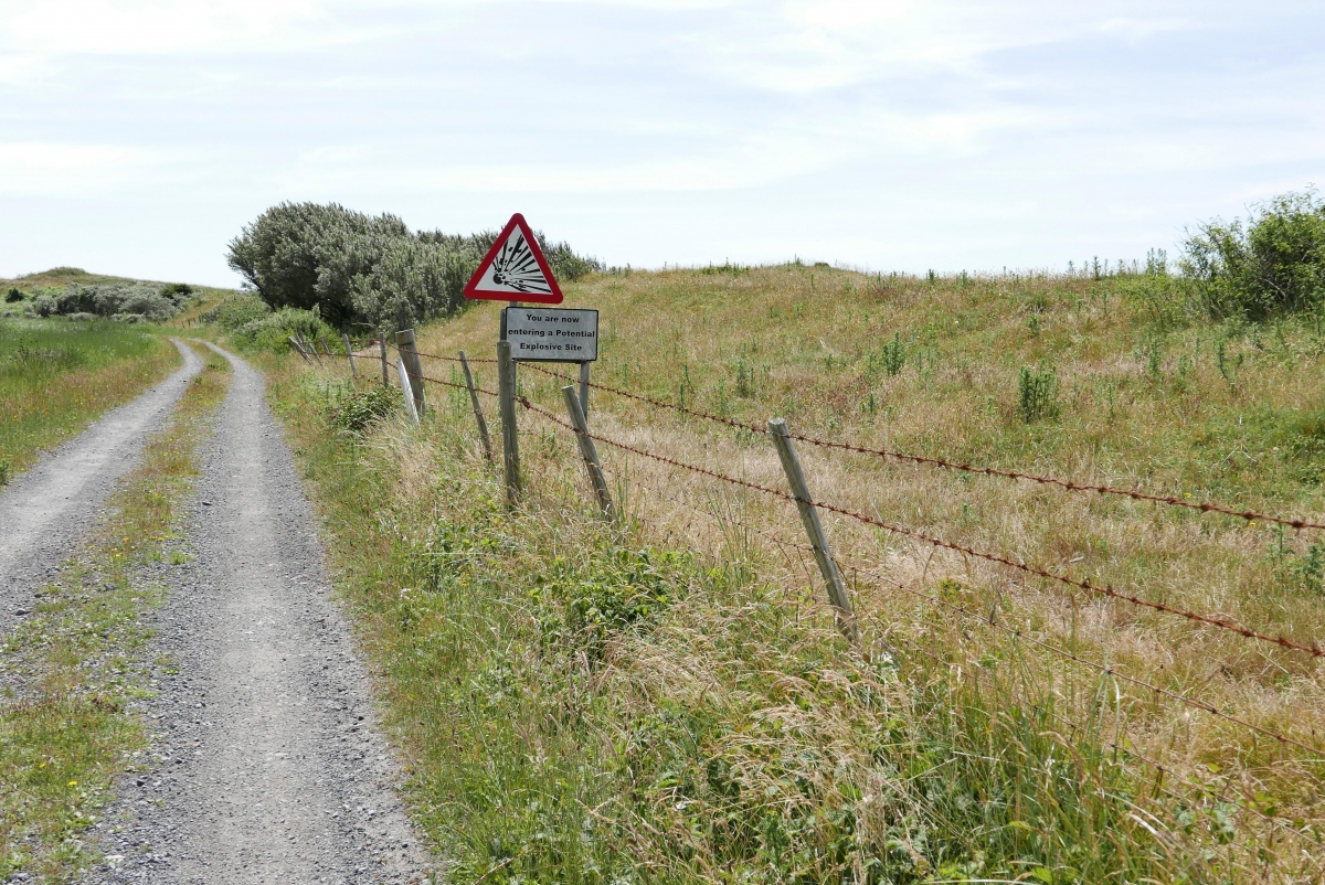
- The argument that the use of marginal land by the MOD and the exclusion of public access are normally beneficial to biodiversity is well rehearsed. Although collaboration with local and national organisations to conserve and maintain habitat is a positive gesture, this still imposes limitations upon access to the broader landscape. It is neither the intention, nor within the scope of this paper to discuss the limitations imposed upon access by a weapons testing area, but also for the sake of the study it is appropriate to acknowledge that this is an influence upon the overall perception by the community of its immediate landscape. There are of course other constraints, including potential unexploded ordinance hazard inherent to the landscape, that affect whether or not it welcomes access:
- Both the Pendine and Burry Port ranges impose restrictions to navigation in Carmarthen Bay and in particular at the entrance of the Three Rivers Estuary. As a consequence sailors have to notify both sites by VHF of their intentions to request access. MOD vessels constantly patrol the area. Taken together with an already hazardous entry these represent a disincentive to both commercial and recreational navigation.
- It is understandable that the less a community is focused upon the foreshore for its livelihood the more disinclined it is to engage in it (unless of course it also happens to be a recreational beach). However, in an interesting gesture of self-determination, the community of Laugharne decided not to accept the NRW (Environment Agency Wales) proposal to install a permanent floodwall across its frontage for the reason that it would compromise the experience of the landscape. In a move that may need reconsideration in future the decision by the community to live with threat and adapt to it rather than expect a benign authority to manage it upon its behalf, is encouraging.
- Given that access to the fresh and salt marshes towards the Burrows is either compromised or not attractive and the town marsh very limited, the key footpath is the Welsh Coast Path, which follows the Taf and therefore overlooks its fringing saltmarshes, taking the road across the landward edge of the Town Marsh and via Sir John’s Hill (Dylan Thomas’s Birthday Walk), it gives a stupendous view of the estuary and the extensive Malt House Marsh. But, apart from evening and weekend access to Laugharne Burrows, this is about as far as the designated provision of access goes, imposing a detached and disengaged experience of landscape and laying emphasis upon the experience of the panoramic views.
Myth, Conjecture and Obfuscation:
In a place so full of history and especially on the West Coast of Wales where oral traditions are strong, it is small wonder that writers such as Dylan Thomas put down roots. Without specifically addressing place it is significant that Laugharne debatably became his muse in the creation of Under Milk Wood and that in turn the community adopted him as a son. It is no small coincidence that when I asked two wildfowlers who I met on the town marsh about the cockle industry, I was told that I needed to talk to Barry Cockle.
In a letter to the novelist Richard Hughes in 1939, Thomas tells him that “what Laugharne really needs is a play about well-known Laugharne characters – and get them all to play themselves”; but strictly speaking, Under Milkwood is a lesson in the capability of communities to transcend time and space and, as discussed, should not be taken as intrinsically bound to place. Just so, in his novel, “In Hazard” written whilst living at Castle House in Laugharne, Richard Hughes based an examination of the behaviour of the crew of a ship, the Archimedes, beset by a Caribbean Hurricane upon the true story of SS Phemius caught up in the 1932 Cuban Hurricane. The common ground shared with Dylan Thomas is in the use of a circumscribed community as a device to suspend a study of human interaction. But, as can be seen in a letter from Thomas to Marguerite Caetani in 1951, this is where their respective intentions diverged:
“the idea (is) that I write a piece, a play, an impression for voices, an entertainment out of the town I live in, and to write it simply and warmly and comically, with lots of movement and varieties of moods, so that, at many levels, through sight and speech, description and dialogue, evocation and parody, you come to know the town as an inhabitant of it.”
Against this Hughes narrative is much more driven by the question of how a highly regulated and structured community copes with the extraordinary experience of complete loss of control and is therefore a more taut, urgent and unsparing work.
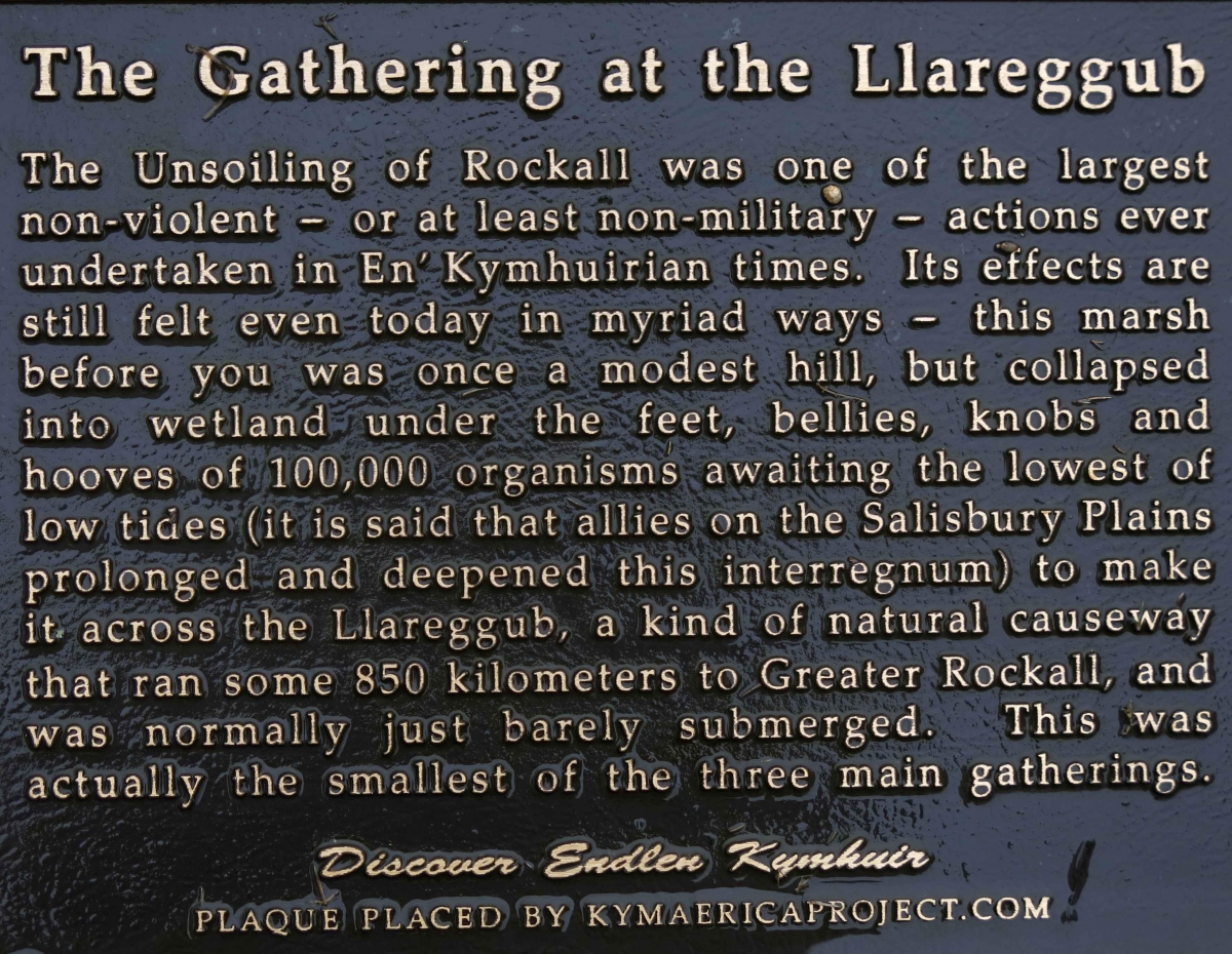
To further digress: on the same walk there is a mysterious plaque that for the unwary, purports to explain the formation of the marshes below. Nowhere is the sense of willing obfuscation more apparent. Although the title: “The Gathering at the Llareggub” nods towards Dylan Thomas, thereon, it departs into a realm of barely plausible fantasy. “The Unsoiling of the Rockall” is the product of an elaborate global exercise, by the artist, Dimitrios Eames to create a parallel universe called Kcmaerxthaere. The partner to this plaque is fixed to the seabed 45 feet down in the Garvellach Islands of Scotland. The fortuitous rescue of the plaque from a skip and its location on Dylan Thomas’s birthday walk is another initiative by Bob Stevens.
In spite of the small size of the community of Laugharne, it appears to have been moulded by a surprisingly broad amalgam of influences. Apart from the silting up of the harbour, these are as various as the effect of Sir John Perrot one-time incumbent of the lordship of Laugharne and who is remembered in Sir John’s Hill as an ironic reference to his propensity for claiming any common land that he could lay his hands on, or the subsequent ruin that his elegant tudor mansion became in 1644 as a result of the civil war. Like any other ancient landscape, Laugharne is the result of all that has happened in and beyond its boundaries, not all of which is even traceable: the possibility that there may be residual memory of extreme events such as the Great Flood of 1607 is intriguing, and although not at present verifiable, it has been cited on the Dylan Thomas Boathouse website as a possible tipping point for the incremental silting up of Laugharne harbour, linking it to the construction of a quay closer to the main tideway in front of the boathouse:
The tsunami theory may be an attractive proposal, but with reference to the description earlier in this document of the influence upon Laugharne of the progradation of Pendine and Laugharne Burrows, there is no concrete evidence to give an alternative interpretation of the build up of sediment in Laugharne Harbour to that of a centuries-long incremental process.
Irrespective of its verifiability, the implication that Laugharne might be struck by a cataclysmic event as depicted by Turner could be embedded in the psyche of the community. It is certainly conceivable that under certain fluke circumstances, when conditions combine, huge surge tides can occur and could sweep unimpeded into the town. Just as in the Turner painting, an exceptional event may overwhelm the capacity of the saltmarsh to attenuate storm driven waves.
Small communities cherish the narratives that contribute to their identity and Laugharne is no exception. Apart from London, it has the distinction of being the only surviving medieval corporation, dating back to 1291. Unsurprisingly it has some particular rituals that support the sense of its uniqueness, such as the Common Walk, essentially a version of beating the bounds, it takes place every three years on Whit Monday, and is a notoriously bibulous and boisterous affair. By all accounts this event is worthy of Dylan Thomas whose story has been considered synonymous with that of Laugharne for over half a century. Although I have proposed Under Milk Wood as a useful model for how communities define their own trajectories, either within or without their landscape; it is only through a heightened sense of ownership and belonging acquired through the stories that inhabit it can they become initiates to their own mysteries.
The Living Memory of the Dead
Through this text I have sought to explore the mutual affect of the evolution of a landscape and the transformation its community has undergone. Although it is certain that there is a degree of anthropogenic causation in the formation of the saltmarsh complex within the Taf Estuary, this is not so much in the process itself but more in the rate at which it has happened. It is demonstrable that the sedimentation of the estuary has been driven by the progradation of the Pendine/Laugharne dune barrier, but the consolidation of this through engineering and reclamation works since the 17th century and the further constriction of the mouth of the Three Rivers Estuary may have accelerated the process and the consequent formation of the saltmarsh in front of Laugharne.
With reference to the studies of the Pendine Barrier by Stuart Walley in 1996 and of the sedimentation of the Taf Estuary by Abdul Kadir bin Ishak in 1997, together with visual and anecdotal evidence gathered by myself, I have acquired greater familiarity with the symbiotic relationship between the geomorphology of the Taf Estuary and the degree that this has coincided with the human history of the area. Although in the first instance, the estuary system provided appropriate conditions to enable settlement and to establish a thriving community, as this continued to evolve it started to foreclose the capacity of the harbour to be operable and for the village to remain strategically a hub for the region. However, it must be understood that this has been such an incremental process that although in epochal terms the development of saltmarsh both at Malt House Marsh and across the frontage of Laugharne has been rapid, in terms of individual human memory, it is slow enough to have barely registered.
On this basis I would suggest that the question of benefit or disbenefit that saltmarsh might bring to this particular community is moderated by the sense that it is perceived as a part of the condition of the landscape and is therefore lived with. Living in the continuing present, in spite of the prognosis of the SMP2, severe change is not considered imminent and any threat such as sea level rise, so gradual as to be accommodated for the time being by home grown solutions. This disparity of view is implicit in the use by government agencies of epochs as a determinant of perceived levels of risk set against the cycle of a community’s experience of located time and the remoteness of a sense of long-term change.
For Laugharne as a community with a livelihood that was once tied closely to its estuary, there is now very little evidence of commercial benefit derived from its location other than from tourism. Admittedly the landscape makes it a wonderful place to live in and it is very popular, particularly for visitors and for retirement, but apart from a limited number of jobs available with Qinetiq at Pendine, seasonal holiday work, and commuting to Carmarthen, there is little other occupation within the town itself. Since very few people have the purpose or the inclination to venture out upon them any more, I question whether for the community, there is much engaged interest in the two main local saltmarsh sites beyond how they enrich the view. For the farmers who graze stock on them, the wildfowlers who shoot upon them and the boat owners who have sheltered moorings in the town saltmarsh, there is a more profound understanding of the marsh, its condition, the tidal cycle, changes induced by weather conditions and the fluctuation of the main ebb channel of the Taf across the estuary.
Inevitably in an interdisciplinary investigation such as CoastWEB, there is so much that is a matter of surmise since, although the scientific data has been exhaustively gathered and the history of the community well documented, definitive links between the two remain confined to the living memory of the dead. Given a theme so nebulous as the perceived value of saltmarsh from a community point of view and the elusiveness of specific historical data, the range of disciplinary expertise applied to the study may serve to illuminate the lacuna between data, knowledge and the degree to which they affect day to day living, but can only make sense when drawn together in an integrated and holistic study. It is axiomatic that whatever research tool is applied to a subject will reveal yet another level of data, by its nature, mine must be a serendipitous process that continually feeds from and intersects with other investigative modes; whatever I discover can only be applicable if it is grounded in and reflects the broader scientific characteristics of the study, which inevitably means that there must be a strong symbiosis between our respective methodological frameworks that act to support, extend, corroborate or confound my own interpretation of statistical, documentary and cultural evidence.
Albeit informed by hard won data, the community’s perception of its immediate environment is the crucible in which this study must be tried. In turn this perception relies upon the condition and identity of the community itself, and is essentially poetic. However rigorous our method may be, it can never be any more than a map of the broader context, which, subject to circumstance, is circumscribed by the caprice of human nature.
“Less than five hundred souls inhabit the three quaint streets and the few narrow by-lanes and scattered farmsteads that constitute this small, decaying watering-place which may, indeed be called a ‘backwater of life’ without disrespect to its natives who possess, to this day, a salty individuality of their own.”
Summary
For me this has been an exercise in linking what is believed to what is known and how public perception is an affect of cultural circumstance as much as physical condition. What follows is a list of understood conditions from which certain conclusions might be drawn.
What we have established:
- The Taf is a macrotidal estuary (high tidal range)
- The Pendine/Laugharne Dune Barrier continues to prograde and Ginst Point to migrate eastwards.
- The constrained entrance to the estuary has a throttle affect upon tidal exchange.
- Consequently, due to deposition of sediment at the entrance of the estuary, the tidal cycle is asymmetric. The result of is that the flood rise when it enters the estuary is faster than the ebb.
- As a result the estuary is flood dominant, exacerbating the tendency for sediment not to leave the estuary on the ebb
- The incremental sedimentation of the Three Rivers Estuary and in particular the Taf, has been taking place for at least a millennium, albeit the cycles of erosion and deposition will have not remained consistent over this time.
- Initially this was experienced as an advantage, permitting the establishment of a sheltered haven and strategic strongpoint at Laugharne and providing suitable conditions for reclamation of salt marsh land behind in the shelter of the dune barrier.
- Subsequently this has caused the continuing formation of saltmarsh on the seaward side of the last reclamation in 1810 at Malt House Marsh and within the embayment across the frontage of Laugharne causing the incremental sedimentation of the access into the town marsh from the estuary.
- Although the growth of saltmarsh has been rapid in geological time, it has also been experienced across generations and noticed over individual lifetimes.
What else we know:
- There was a surge tide event in 1607 that had a major impact upon the South Wales Coast and Bristol Channel ports, which may have had an impact upon sedimentation in the Taf Estuary.
- There exist photographs from the 19th century of substantial vessels drawing up to and over 1.5m, moored up in the tidal basin formed in the River Corran beside the Strand, which is a relic of the previous harbour. According to photographic evidence, this practice continued well into the 1930’s although, by the unrigged condition of the vessels, it appears that the site may have been either used for laying-up or for sheltered winter storage. These images also testify to the depth of the estuary and the navigability of the shoals at its entrance during those times.
- Due to the tidal range it is unlikely that vessels ever laid afloat at Laugharne through an entire tidal cycle and as a consequence took the ground at low water.
- Although the use of the saltmarsh channel complex at Laugharne continues to be exploited as a sheltered mooring for shallow draught boats, this remains limited by the tide and is becoming increasingly difficult.
- By the early 1900’s the use of the quay had become increasingly constrained for landing cargoes of coal and in 1913, a quay was constructed in front of Dylan Thomas’s Boathouse to facilitate access for vessels of deeper draught.
- According to the OS map, ordinary high tides reach the edge of the Strand
- There is continuing evidence of high storm tides reaching beyond the Strand at Laugharne well into the 19th century to the present day. The vulnerability to tidal flooding of the properties along the frontage of Laugharne remains of sufficient concern to have been included in SMP2.
- Although access to Ginst Point and Laugharne Burrows is permitted, this is only when the Cinetiq site is not in operation during evenings and weekends.
- The footpath between complex across the East and West Marshes is disjointed or fallen sufficiently out of use to discourage access.
Conjecture:
- Although the proposal that the 1607 storm surge was a tipping point in the silting up of Laugharne harbour appears as a claim in www.dylanthomasboathouse.com, I have been unable to identify any supporting evidence for this.
- There may be a point in the future when the tidal and fluvial system of the Taf will stabilize, when the scouring and re-suspension of sediment through the effects of scour on the ebb, may balance the amount of deposition on the flood.
- Alternatively the increased constriction of the estuary mouth and increased sedimentation may increase tidal velocities at the entrance and lower tidal range further within the estuary.
What this means for the community:
- Although there is a history in the area of living with saltmarsh, a key occupation linked with the intertidal zone was cockle picking which happened on the foreshore and on tidal flats at low water. At present, this does not take place close to the town and even at sites such as Ginst Point it is banned due to disease and stock level issues.
- Further historical activities include the import of coal until road transport took over, fisheries, foraging for marsh vegetation, and the unusual creation of burning fuel through a mixture of coal dust bound in mud.
- The marsh at Laugharne still provides shelter for recreational vessels, particularly those used for angling. As above, this is becoming increasingly constrained by the tides and depth of water in the channels.
- A local farmer grazes stock upon the Malt House Marsh. This is mainly sheep but also cattle. These tend not to venture beyond the high marsh grassland. This area becomes heavily trampled, which makes walking along the seaward side of the Freething Wall difficult.
- Unlike other locations such as the East Anglian Coast, the saltmarsh is not extensive enough to become an independent landscape with its own distinct culture and society. Although on the Taf it has a material influence upon the way of life by cutting the community off from direct access to the estuary and historically by providing land of a suitable elevation for reclamation, the link it has with local culture depends upon the degree of habituation to it, individual livelihood, family memory and association.
- In other locations, saltmarsh is frequently considered alien and unclean. This may be exacerbated by the suspicion that the muds could harbour human and agricultural waste passing through and into the estuary. It represents a transitional zone between what can be controlled and what cannot. It remains a matter of conjecture whether this view can be applied to Laugharne.
- Conversely saltmarsh is an accepted part of a place, something to be habituated to, disliked by some but cherished by others.
- Although it may be appreciated that saltmarsh is an asset and a resource, it is debatable how much it is valued as such by the local community. It is appreciated however that the presence of saltmarsh will act to attenuate storm driven wave and tidal action and their impact upon the low lying properties at the Grist and along the Strand.
- It is however valued as a safe mooring for boats. Laugharne Corporation manages the moorings and grants the licenses for them
Transferability of findings to the Mawddach case study site:
- Although it is intended to reflect upon a broad range of Welsh coastal landscapes through the use of the Taf and the Mawddach Estuaries as case study sites, it is in their nature that some material will be transferable and some will not. From the start of this summary, it is clear that whilst some generic lessons may be drawn, many of the characteristics of both Laugharne and its situation upon the Taf are utterly unique. In this respect, caution must be exercised when applying principles of saltmarsh generation as experienced on the Taf to other estuarine locations.
- The tidal range at max 5m on the Mawddach is not so extreme as on the Taf at 8m.
- Although both the saltmarshes on the Taf and the Mawddach are grazed, this tends to be restricted to the upper marsh on the Taf, possibly due to its higher tidal range.
- There will be some merit in the comparing and contrasting the two case study sites since the dynamic of the Mawddach Estuary is also distinctive. Although both estuaries respond to a constrained entrance and correspondingly a high degree of sedimentation, the similarities do not go much further than that. How this is manifested is unique to both systems.
- The drivers for socio-economic development on both the Taf and Mawddach are also particular and will benefit from further study. These include characteristics such as the location of the salt marsh sites in relation to the development of harbour facility, the shelter afforded by coastal features such as the dune barrier at Pendine and the Ro Wen Spit at Fairbourne, the degree of exposure to storm action and the relative vulnerability to fluvial discharge.
- In order that compatibility may be established between The Taf and Mawddach Estuaries and to allow applicability to other coastal sites, I intend to establish a consistent methodology, which for me must be anchored in an understanding of the estuary system and work in tandem with a reflection upon the history of the community and the degree to which this has evolved reciprocally with changes in the intertidal zone with a particular reference to saltmarsh.
Bibliography
Walley, S.S. 1996. Holocene Evolution of a Coastal Barrier Complex, Pendine Sands. School of Ocean Sciences, University of Wales, Bangor
Bin Ishak, A.K. 1997. Suspended Sediment Dynamics and Flux in the Macrotidal Taf Estuary, South Wales. School of Ocean Sciences, University of Wales. Bangor
Haslett, S. 2011 Earthquakes, Tsunami and Nuclear Power, Relevance of the 1607 flood in the Bristol Channel. Blackbarn Books. ISBN: 978-1466489875
Horsburgh, K. Horrit, M. 2007. The Bristol Channel Floods of 1607, reconstruction and analysis. Pp272-277. Weather. Royal Meteorological Society. https://doi.org/10.1256/wea.133.05
James, T. 1991. Where the Sea Meets the Land: The changing Carmarthenshire coastline. In H. James (ed) Sir Gar; Studies in Carmarthenshire History: Essays in memory of W.H Morris and M.C.S Evans, Carmarthenshire Antiquarian Society, monograph series No 4
Dylan Thomas. 1954. Under Milk Wood
Hughes, R. 1938. In Hazard
Steinbeck, J. 1945. Cannery Row
Thomas, D.N. 2004. Dylan Remembered: Volume Two 1935-1953: 2
Ferris, P. 1985. Dylan Thomas: The Collected Letters
Halcrow Group Ltd. (2012), Lavernock Point to St. Ann’s Head Shoreline Management Plan SMP2, Tech. rep., Swindon.
Thomas, M.J. 2013. Public and Expert Perceptions of Sea-level Change on the Severn Estuary. Cardiff University
Alldred, M. Liberti, A. Baines, S.B. 2017. Impact of Salinity and Nutrients on Saltmarsh Stability. ESA. Open Access Journal
Defoe, Daniel. 1704. The Storm
Moeller, I. Friess, D.A. Spencer, T. Hill, R. 2014. Coastal saltmarsh managed realignment drives rapid breach inlet and external creek evolution, Freiston Shore (UK)
www.cefas.defra.gov.uk. 2014. Classification of Bivalve Mollusc Production Areas in England and Wales. Sanitary Survey Report. Three Rivers Estuary
Tyler, R.H. 1925. Laugharne Local History and Folklore