[custom_frame_right]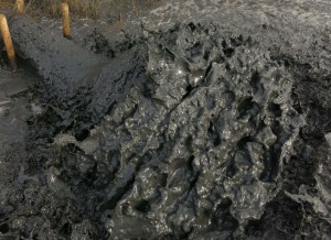 [/custom_frame_right]Saltmarsh management scheme 2014/5
 [/custom_frame_right]
Report prepared by Simon Read with support from Karen Thomas and Trazar Astley-Reid
Project Proposal: Each year Suffolk Yacht Harbour at Levington on the Orwell Estuary in Suffolk must undertake a dredging campaign in the winter months to ensure sufficient depths at all states of the tide for its pontoon berths. Since 1993, it has been licensed to deposit dredging spoil at managed sites on the foreshore approved by Defra and Natural England. The amount discharged annually is between 15,000- 20,000 cubic metres.
The proposal for 2014/15 was to transfer the operation to two degraded SSSI habitats within the SPA (European Marine Site). It has been estimated that the area of saltmarsh has decreased by 59% on the Stour and 46% on the Orwell between 1973 and 1997. The Stour and Orwell SPA supports in excess of 20,000 waterfowl.
These sites are adjacent to the Yacht Harbour: to the West on the fringing saltmarsh at the head of Levington Creek and to the East on a high mudflat behind a historically breached defence beside Loompit Lake.
The Stour and Orwell Estuaries Management Group (S&OEMG) and Suffolk Yacht Harbour at Levington agreed to collaborate upon this project as a pilot to raise the profile of the strategy for the beneficial use of dredging spoil for saltmarsh restoration. This approach is consistent with the strategy identified in the South Suffolk and Essex Shoreline Management Plan 2011 (SMP) by the Environment Agency as a cost effective option that delivers wider environmental benefits.
The partners in this scheme are Suffolk Yacht Harbour (SYH) and the Stour and Orwell Estuaries Management Group. Suffolk Coast and Heaths Unit (SCHU) supported SYH at a consultative level towards securing the marine license to allow placement of dredged material in new intertidal areas and securing partnership funding elements for the project. The Environment Agency supported the project through providing aerial photographs and LIDAR data and by providing technical expertise and experience through on-site consultation. Suffolk Wildlife Trust have been actively engaged through cooperating over the laying of the pipework over their nature reserve and agreeing to carry out the monitoring programme. The estimated budget for the project including pipework, structures and manpower was £60,856.20, whilst the working fund was £61,199. This fund was made up of in-kind support from Suffolk Wildlife Trust, £4000, and Ipswich Borough Council, £3,000, Environment Agency, £12,000, Suffolk Yacht Harbour, £7,000, Suffolk County Council, £10,000, ABP Ipswich, £2,000, AONB Sustainable Development Fund, £3,000, VEOLIA, £14,199 and £5000 from Suffolk Coastal District Council.
This project was preceded by a thorough consultation exercise, starting in 2012, where all interested parties, stakeholders and local community members were invited to attend events set up by the Stour and Orwell Estuaries Management Group. Consents and licenses were gained from Natural England, Environment Agency and the Marine Management Organisation. The main guidance for this project is the consultation document: “Stour and Orwell Estuaries Management Group working in partnership with Suffolk Yacht Harbour Levington Saltmarsh Restoration & Beneficial Use of Dredgings Project 2013” produced by Trazar Astley Reid and updated in 2014.
The proposal is to extend the pipeline to each of the two sites and to pump from the western end of the marina via existing concrete drains in the wall of the nature reserve beside the saltmarsh at the head of Levington Creek and from the eastern end into the top corner of the Loompit Lake Site. Prior to the operation, each site would be prepared by placing systems of bunds to retain the silt. It is expected that this will be reviewed and monitored on an annual basis and any adjustment deemed necessary to ensure the continuing efficacy of the project should be put in place.
[custom_frame_right] [/custom_frame_right] Trazar Astley-Reid of SCHU and Karen Thomas of Environment Agency conducted the initial scoping of the project with Jonathan Dyke of SYH. As a result of this a basic strategy was agreed to make low-key interventions in the channel systems of the two sites, using materials such as coir in innovative ways. SCHU worked up this approach with Kieran O’Mahony, Environmental Scientist and Simon Read, Visual Artist to establish a sustainable design for this intertidal landscape as a model for future initiatives.
An account of the works carried out on site: The aim of this project is to sequester sediment from the annual dredging operation of Suffolk Yacht Harbour and to use it as recharge on two degraded saltmarsh sites immediately to the West and to the East of the Marina. Upon completion, Suffolk Wildlife Trust has undertaken to manage the monitoring programme.
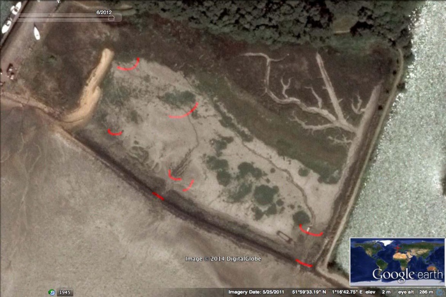
The West Marsh is a substantial area of degraded saltmarsh between the entrance to Levington Creek and Suffolk Yacht Harbour. Although seasonally there is a good crop of Samphire (Salicorna Europaea), Cordgrass (Spartina Anglica) and Sea Aster (Aster Tripolium), there is insufficient overall elevation for this to progress any further beyond pioneer growth apart from a margin of middle marsh close to the defence wall and in isolated patches in the body of the marsh that have been colonised by Sea Purslane (Halimione Portulacoides) and Sea Lavender (Limonium Vulgare).
The proposal is to install a complex of low barriers within the channel system in order to hold back sediment pumped into the site by the yacht harbor during its seasonal dredging operation.
This is a collaborative project between Suffolk Yacht Harbour, and the Stour and Orwell Estuary Management Group, designed and implemented by Kieran O’Mahony and Simon Read. For all parties there is an understanding that the advantages derived from this project are mutual: Suffolk Yacht Harbour could and would have continued to deposit dredging spoil on the foreshore locations in a way that prevents it from returning to the tideway. Transferring the operation to the two new sites will ensure the benefit of an influx of sediment that should eventually raise the levels of the marsh beyond pioneer stage and into a succession of healthy saltmarsh vegetation. This in turn will enhance the biodiversity of the foreshore and provide greater resilience against tidal and wave action.
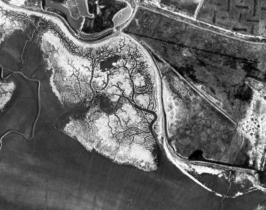
West Marsh, reversed to clarify the channel system.
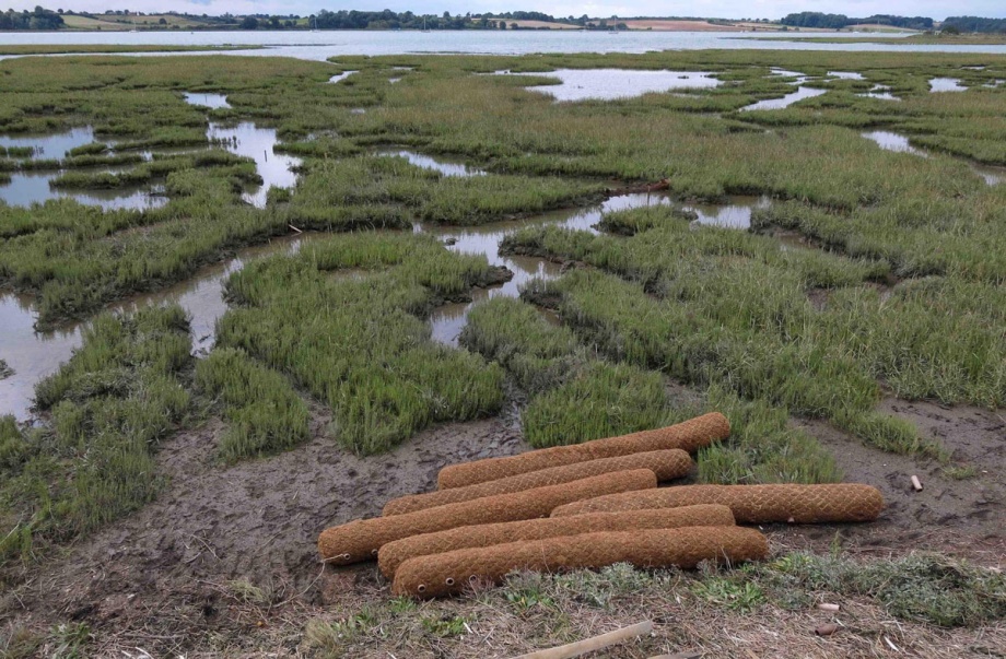
The relative levels of the drain channels and the crest of the saltmarsh are very slight, frequently less than 500mm. Since it does not make sense to install structures reaching beyond these dimensions, we decided to work exclusively with Coir Logs staked directly into the channel bed to impede flow and facilitate the deposition of sediment during the dredging operation. Our approach to this was:
- Map the site and discern the gradients and direction of flow within the marsh.
- Strategically place Coir Logs within the system to incrementally interrupt flow, but avoid the build up of bodies of standing water sufficient to increase hydraulic pressure to the extent that it will cause failure either through undermining or diversion.
- In the first instance, 48 Coir Logs were staked into the channels radiating from the proposed discharge point. In an effort to mitigate the effects of higher velocities and levels of flow, these are positioned more tightly together near the point of discharge than at the outer limits of the channel system.
- The installation took 5 days from 18th to 23rd August 2014.
Coir Logs to be located on the western site. 18th August 2014. copyright: Simon Read
This is deliberately a very low-key intervention, with the expectation that it may need additional structural intervention during the course of the dredging campaign and year on year as levels rise.
Suffolk Wildlife Trust have set up a monitoring programme based on transects, fixed-point photography and horizon markers.
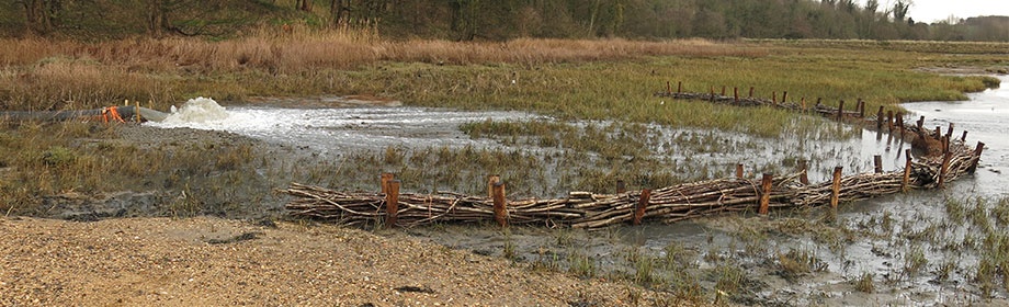
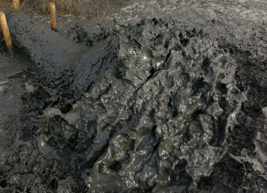
December 19th 2014: After six weeks dredging, the entire channel system within 50metres of the outfall has become smothered by spoil and the coir bunds further downstream are noticeably holding back sediment. After a period of settlement, there will be one further discharge at this site before attention is transferred to the south site beside Loompit Lake.
[justified_image_grid ids=728,730,729 row_height=250]
Channel system, after the installation of coir logs, during and after completion of pumping operation.
Upon completion of this current season’s dredging operation, it is anticipated that the spoil will settle and perhaps stabilize with pioneer vegetation (most likely Salicorna Europaea and Spartina Anglica). If the new sediment has become stable enough, there is potential for a further continuous outlying structure to encourage levels to build and to establish succession.
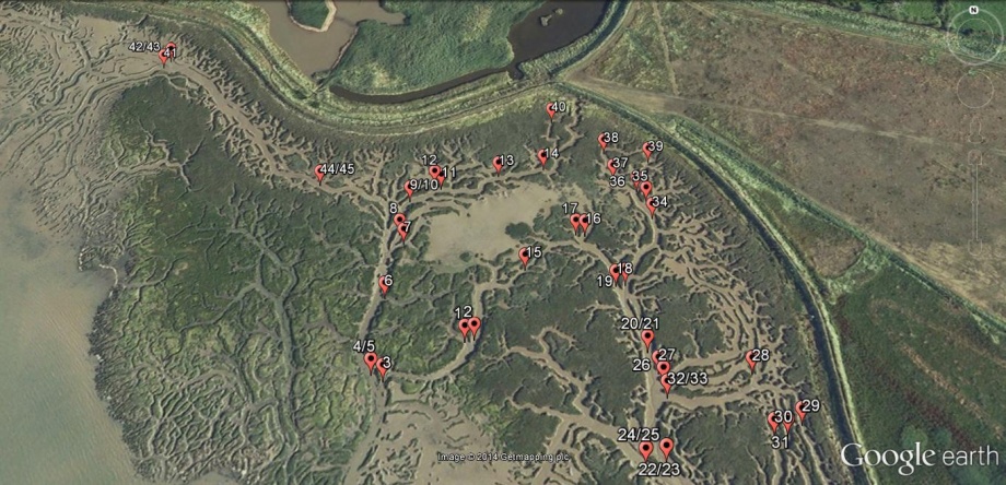
Locations of Coir Logs on North Site
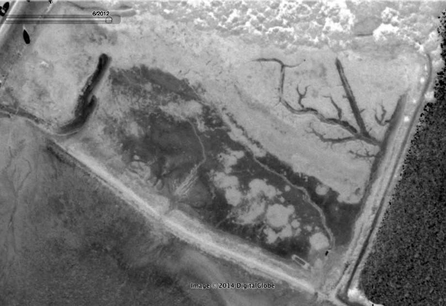
The East Site Beside Loompit Lake Is Predominantly Mud Flat With Very A Small Saltmarsh Fringe Of Mainly Sea Purslane And Cordgrass Towards The Landward Side. There Is A Substantial Plume Of Sand At The Western End That Has Progressively Built Up Over At Least Ten Years. This Is Possibly The Result Of Sediment Dropping Out From Dredging Spoil Discharged On The Adjacent Foreshore And Carried In On The Ebb. In The Shelter Of This Formation Examples Of Other Vegetation Types Such As Shrubby Sea Blight (Suaeda Vera), Golden Samphire (Limbarda Crithmoides) And Frosted Orache (Atriplex Laciniata) Have Been Recorded.
The Site Was A Reclaimed Field Where Historically The Defences Had Failed Upriver Before The Construction Of Suffolk Yacht Harbour. From Then The Process Of Returning To An Intertidal Landscape Has Followed A Predictable Cycle Where, In The First Instance, Saltmarsh Vegetation Colonised The Hard Clay Of Drained Pasture. As The Original Clay Defence Walls Progressively Disintegrated, Tidal Ingress Became More Dynamic, Eroding The Derelict Pasture Whilst Depositing Soft Estuarine Silts. Towards The North Of The Site Where It Meets Rising Land, This Process Is Slowing Down Although The Saltmarsh Vegetation Continues To Die Away. As In Many Sites Where Reclaimed Land Has Returned To The Intertidal Zone, It Remains In A Transitional State For A Surprisingly Long Period Of Time. Eventually Without Intervention It Must Reach Some Kind Of Equilibrium; But Through Artificially Lowering The Tidal Dynamic Within The Site And Introducing Dredging Spoil As Recharge, This Process Is Likely To Be More Rapid And Sustainable Over A Much Wider Area.
Loompit Lake site reversed to highlight mudflats and channel system
At present the state of the original sea defence wall is vestigial having eroded back to its riverstone core, no higher than high water neaps. The gradient of the site is oriented roughly northeast southwest; as a consequence it currently drains through two breaches, the main one at the southeast corner beside Loompit Lake and the other at the centre. The strategy for managing the discharge of dredging spoil within the site is threefold:
- Block the two main breaches in the original defence wall to ensure that the spoil will not be carried out directly into the tideway and that tidal exchange within the site will be controlled.
- Construct a pen of brushwood backed up with coir logs using coir blanket around the outfall to mitigate the immediate effects of scour at point of impact.
- Construct a series of low bunds within the site to manage increased flow, discourage the tendency to form substantial drain channels and to encourage deposition as evenly as possible across the site. This is a low-key intervention using coir logs similarly to how they were deployed on the north marsh.
[justified_image_grid ids=738,739,740 row_height=200]
February 2015. Copyright: Simon Read
The strategy for the intervention at this site was agreed during Autumn 2014 and installation took place during the weekend of 10th/11th January 2015. Sediment pumping was commenced on site during the week of 19th January. The behaviour of the installation was checked on Monday 26th January and it was seen to be operating efficiently and that flows over the mudflat mitigated well by the complex of coir barriers.
Location of Coir Logs and bunds on the Loompit Site
After the completion of the dredging operation at the Loompit Lake site, it became clear that the bunds that had been put in place had been effective in retaining sediment within the site and ensuring that the existing channel systems were not scoured deeper. Once the sediment has settled, it will become clearer whether or not further work will be needed on the site before the next season.
[justified_image_grid ids=747,745,746 row_height=200]
Loompit Lake site after the completion of dredging operation. March 2015. Copyright: Simon Read
There may be a tendency for alternative channel systems to develop on the both East and West sites, however, it is agreed to wait until after the completion of the dredging operation for the current year before deciding upon whether it will be appropriate to install further adaptive measures.
Recommendations and Conclusions:
- Use of dredged material beneficially to enhance degraded marsh areas is a technique that can be used relatively cheaply by local marine businesses.
- Innovative materials like coir can be employed alongside traditional brushwood polders in the marine environment to provide structures to trap sediment and retain dredged material in situ.
- Partnership working is key to maximise design expertise and funding and gain permissions and consents.
Suffolk Wildlife Trust will be monitoring the project but initial findings (March 2015) are encouraging and the intertidal areas are trapping the dredged sediment successfully.
This project is a pilot and case study for the Essex and South Suffolk SMP and will be part of a strategic Beneficial Use of Dredgings Strategy being led by the Environment Agency.
Both Suffolk Yacht Harbour and the Beneficial Use of Dredgings Startegy project will report back to the Essex and Suffolk Coastal Forums to encourage buy-in from statutory and non-statutory organisations and highlight the benefits of this technique for marine businesses and the local environment.
Acknowledgements:
Thanks go to Trazar Astley Reid as the Suffolk Estuaries Officer working for the SCHU who advised Stour and Orwell Estuary Management Group, along with Jonathan Dyke as owner of Suffolk Yacht Harbour for hosting a pilot project at Marina. Thanks also to Karen Thomas (Environment Agency) who gave expertise to develop the design of the sites and Emma Hay (Natural England) for supporting the approach.
Thanks to Simon Read and Kieron O’Mahony for designing and installing the structures and to Dorothy Casey and Andrew Excell of Suffolk Wildlife Trust for agreeing to works on their land, undertaking the monitoring programme and giving enthusiastic support throughout the development of the project. Carol Reed for giving technical advice and support on the viability of the project and John Brien of Harwich Harbour Authority for giving support over the dredging license protocol.
Thanks also to the funders which in addition to Suffolk Yacht Harbour were; AONB Sustainable Development Fund, VEOLIA, Environment Agency, Suffolk Coastal District Council, Suffolk County Council, ABP Ipswich, Ipswich Borough Council, Suffolk Wildlife Trust.
References:
Stour and Orwell Estuaries Management Group. Management Scheme and management strategy: http://www.suffolkcoastandheaths.org/projects-and-partnerships/stour-and-orwell-estuaries-management-group/
Stour & Orwell Estuaries Management Group working in Partnership with Suffolk Yacht Harbour: Levington Saltmarsh Restoration & Beneficial Use of Dredgings Project 2013.
Produced and updated by Trazar Astley-Reid Suffolk Estuaries Officer for the Stour & Orwell Estuaries Management Group May 2014
“Maintenance Dredging Protocol Baseline Document”. Harwich Harbour Authority: http://apps.hha.co.uk/library/files/F03C8865-664E-409F-A6E8-4F4BEC761C66.PDF
South Suffolk and Essex Shoreline Management Plan: http://www.eacg.org.uk/docs/smp8/essex&southsuffolk%20smp%20final%202.4.pdf
Simon Read, Associate Professor, Middlesex University London.